SAN PEDRO OF ATACAMA
Location and access: 103 km to the southeast of Calama, by paved road. Famous town-oasis surrounded by small pre-Hispanic towns called Ayllus. In this expedition you can ascend to the volcano Licancabur, to practice mountainbike or to explore the Camino del Inca which is a path that crossed and united the whole Inca empire at the same time. From San Pedro of Atacama you can take walks to Pukará of Quitor 3 km from there; one can also make mountainbike and reach the Valle de la Luna, 13 km from the town.
GEYSERS OF THE TATIO
Location and access: 95 km to the northeast of San Pedro of Atacama -by non paved road- ideal for four-wheel drive vehicles. This place is at 4,000 m. over the sea level, and it is recommended to take walks, but keeping a prudent distance from the geysers that spring early in the morning.
VOLCANO LICANCABUR
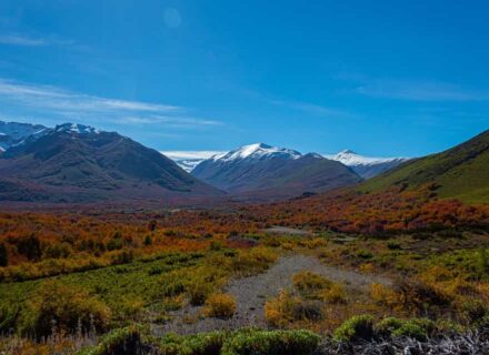
Location and access: it is located to the northeast of San Pedro of Atacama, at 5, 916 m. over the sea level. The climbing begins among dry ravines and curves until arriving at the edge of the volcano cone, surrounding it for the south. The most astonishing panoramic view of the salar at dawn will be in front of you, with perfect visibility of the oasis San Pedro. The climbing allows you to practice off road or mountainbike. Mountain chains, mountains and hills
SALAR OF ATACAMA
It is located 100 km from San Pedro of Atacama. The solar rays cause the evaporation of the water, accumulating the salts that stuff the basin of the great Salar de Atacama. Its extension overcomes the 3,000 km square and on its edges there is a varied flora and fauna.
The flat, horizontal surface of the salar was formed -from remote times- with the contribution of rivers, slopes and underground waters that accumulated in this natural basin. It has no drainage and it has great dimensions. When its waters evaporate -because of the solar rays- the concentration of salts and minerals take place, being deposited in scabs of varied forms and colors.
The animal and vegetable lives became adapted to such a degree of salinity that today -as it was in the past-, it is relatively easy to penetrate into this white lake and find vegetables, dragonflies, coleopterans and flies, rodents, birds, flamingos of Andean type, chilensis and jamesis. VOLCANO It is located 60 km to the east of San Pedro of Atacama. It has an altitude of 5,916 m. over the sea level; from its summit you can appreciate a considerable radius of the surroundings. You can see the oasis of San Pedro of Atacama, the Salar de Atacama and the Laguna Verde, in Bolivia.
During a visit to San Pedro of Atacama the volcano is always present in the landscape due to its proximity. It has an impressive vertical difference of level of more than 3,600 m. high.
It is possible to climb up to the cone, passing ravines and curves; the length is around 12 hours by walking. In the crater there is a lagoon covered with ice during winter. To carry out this climbing you have to be in perfect physical conditions, have experience, their own climbing equipment and a good capacity of adaptation to the altitude.
SALAR OF ASCOTÁN AND CARCOTE
It is located 187 km to the northeast of Calama. In these salares an own aquatic bird fauna is presented, standing out the parinos huallotos, taguas, huaychos and wild ducks. Vestiges of a human settlement are also manifested.
The area presents a rigorous climate, of low temperatures, scarce humidity, strong winds and summer rain, all of them characteristics that produce a great atmospheric clarity, standing out the landscape that leads to the place. It is composed by the volcanoes San Pedro, San Pablo, Ollagüe and Miño and the salares Ascotán and Carcote. This area is located between 3,000 and 4,000 m. over the sea level approximately and it is next to the frontier with Bolivia. The road -both railway and for vehicles- crosses both salares.
OLLAGÜE
It is located 187 km to the northeast of Calama. Border town located to an approximate altitude of 4,000 m. over the sea level. The surroundings contemplate mountains and volcanoes, and characteristic flora and fauna of the Andean highland.
The commune of Ollagüe has an extension of 2,884.75 km square and the its main towns are Ollagüe, Amincha, Cebollar, Ascotán and Coska. Ollagüe has a Border Complex and it has basic services. The main activity of the inhabitants is in the saltpeter offices located in the surroundings. The celebration of San Antonio de Padua is the main religious celebration of the place. It takes place on June 19th, with ceremonies of Quechua origin.
There are two main winter periods in the year: the highland winter (December to March) when the temperatures fluctuate between 50º and 60º F, and the seasonal winter with winds, storm, hail, and low temperatures that reach -20º and 43º F (June to September).
CORDILLERA DE LA SAL
Location and access: 70 km from Calama. Before entering San Pedro of Atacama you can appreciate its natural attraction for both sides. Hills with unusual forms, colors and mineral shines. It is an emerged bottom of a lake, with horizontal layers of lake sediments, which have become vertical because of some foldings in the layers of the Earth. The highway crosses this mountain chain and it begins to descend towards the great Salar de Atacama. When descending you can find some rocky places, with a spectacular panoramic view of the great salar.
GEYSERS OF THE TATIO
Location and access: 95 km to the northeast of San Pedro of Atacama, by non paved road -ideal for four wheel drive vehicles.
Approximately between 6 AM and 7 AM the maximum expression of these vapor fumaroles takes place. Their waters reach 176º F and they strongly emerge from the earth, reaching approximately heights of 8 to 9 m.
On the route and in the Tatio it is possible to observe vicuñas, llamas, nandues and vizcachas, while -regarding the flora- the giant cactus, the llaretas and the coirón grass stand out.
In summer the temperature reaches 60º F during the day and 30º F at night.
It is a geometric field at 4,321 m. over the sea level, surrounded by high summits originated by the proximity of the volcano Tatio, where vapor jets of boiling water outcrop. Their borders of mineral salts are soft, and the coloring of the floor and sky stands out among the columns of vapor up to 8 to 9 m., high under the first sunbeams

Desert
VALLE DE LA LUNA It is located 13 km to the northwest of San Pedro of Atacama. It belongs to the National Reservation Los Flamencos. The valley has as morphology a curious similarity with the lunar landscape. For this reason it has taken the same name.
Geologic sight located at 2,600 m. over the sea level, belonging to the Cordillera de la Sal. The saline material that composes this mountain chain is very susceptible to erosion and to be dragged by the wind and other atmospheric agents. These have originated different and winding forms that characterize this area. It is also one of the places where the desert has its biggest rigorousness, since in the whole area there are no evidences of humidity, vegetable or animal life, which make it the Historical places and National Monuments
CHURCH SAN FRANCISCO DE CHIUCHIU, declared National Monument in 1951.
Located 30 km to the northeast of Calama. Declared National Monument for their architectural lines and for being one of the oldest in the country, since its construction dates from beginnings of the XVII century. Its structure is of a single deck, its interior is sober and it has valuable samples of colonial art.
CHURCH AND CAMPANARIO DE CASPANA, declared National Monument in 1951.
Construction declared National Monument for their architectural lines and for the antiquity of its construction that dates approximately from 1641. Located at the end of the town, dominating the ravine and the village. It is of a single lengthened deck of about 20 for 40 m., with walls of stone stuck with cement, plastered with mud and whitened with lime; the structure of the roof is made of cactus wood and straw.
CHURCH OF SAN PEDRO DE ATACAMA, declared National Monument in 1951.
Located to a side of the square. Built around 1745. It is characterized to be simple and sober, presenting an architectural unit made in stone and plastered adobe. The structure of the roof is made of chañar wood and carob tree.
PUKARÁ DE LASANA, declared National Monument in 1981.
It is located 8 km to the north of ChiuChiu. This old indigenous fortress was built in the XII century, and is one of the most important relics in the Atacama cultural area of Chile. For this reason it has been declared National Monument.
It is a vestige of what was a fortified village lifted on high lands -valley of Lasana-, where the villagers lived and worked always attentive and protected. This area was dominated by the Inca, achieving a great empire. The Inca Tupác Yupanqui had reached these territories about 50 years before the arrival of the Spanish, imposing its own system of life.
PUKARÁ DE QUITOR
This is a pre-Inca construction of the XII century that is located 3 km to the north of San Pedro of Atacama and that -due to its age and importance- has been declared National Monument. It was built with stones that climb a hill as a fortress with a perimetric defensive wall. It is located in a corner of the ravine where the river San Pedro or Río Grande flows. Right there, on a pronounced slope, you can find the ruins of Pukará de Quitor. It takes its name from the pre-Hispanic agrarian grouping, the “Ayllu of Quitor” which cultivation fields are next to the Pucará Quitor fortress. This fort was built during the XII century, as an answer to the expansionary designs of the aymara neighbours. In Quitor all the constructions are made of stone, generally not hewn and extracted from the liparita bank.
The housings and their small enclosed silo, the defensive enclosures that are noticed in the periphery and attributed to the same defensive wall, the enclosures that store grains and the watchtowers, complete 160 all together in a surface of 2.5 hectares. A great part of this hillside has a height of 70 meters, counted from its contiguous base to the cultivation fields until its ending point. The roofs are always one-sided, plane or with very little inclination. The same techniques have been both in Quitor and Lasana: chañar beams or carob tree, branches, and Ichu straw covered with mud.
PUEBLO ABIERTO DE PEINE, declared National Monument in 1982. It is located 102 km to the south of San Pedro of Atacama. In the north margin of the ravine of Salar de Atacama you can find the ruins of the pre-Hispanic open town of Peine, and in front of this -in the south hillside of the same ravine- the new town of Peine, lifted during the XVII century and that was crossed by the Camino del Inca. These open towns also called “old ports”, correspond to a period previous to the construction of the pukaras -lifted in the course of the XII century in the valleys of Salado river and Salar de Atacama. These “pukaras” were built next to the slopes of water with the purpose of developing their organization based on an agrarian, self-sufficiency economy. This is already reflected in the equivalence of size of the community fields no longer for cultivation or shepherding. The built area reaches 80 to 200 m. The roofs of the constructions are flat with little inclination, rafters, branches, straw and mud.
OFICINA SALITRERA CHACABUCO (SALTPETER OFFICE), declared National Monument in 1971. Located approximately 200 km to the south of Antofagasta. This office used to support a population of around 1,700 people, covering a surface of 37 hectares. Its equipment included a hospital, school, grocer s shop, mail, hotel, sport courts, theater, etc. Its production capacity reached the 15,000 tons monthly of saltpeter. It was restored with German government s funds in 1972.
RUINS OF HUANCHACA IN ANTOFAGASTA, declared National Monument in 1974. Located between the avenues Angamos and Argentina. Declared National Monument for being one of the biggest silver foundries installed in South America towards 1878. It is a stone structure that looks like a great fortress. From its summit you can appreciate a panoramic view of Antofagasta.
CUSTOMS ANTOFAGASTA, declared National Monument in 1976. Located in 2786th, Balmaceda street. Built in 1888. The structure is divided with walls based on diagonal pillars of oregon-type pine. There are rafters made of the same wood type, small beams and “tijerales” of the roof. Currently it is the headquarters of the Regional Museum.
SQUARE JOSÉ FRANCISCO VERGARA, declared National Monument in 1980. Located in the Campus of the Universidad de Antofagasta. Accurate testimony of the past mining gest of the Oficina Salitrera Vergara. The square has four octagonal wooden arbors, fourteen floral trays, bushes and trees, and a central kiosk.
National Parks
NATIONAL RESERVATION LOS FLAMENCOS
It is located 104 km to the southeast of Calama. The reservation has 73,986 hectares -subdivided into 7 sectors. Each one of them has its own flora and fauna characteristics, climatic differences, archaeological resources, rocky formations, among other countless attractions. The sectors that form this reservation are: Salar de Tara, Salar de Aguas Calientes and Salar de Pujsa -located in the high plateau-, Lagoons Miscanti, Miñiques, Valle de la Luna and Tambillo. In the sector of Salar de Atacama, you can find Soncor and Laguna de Quelara. The scenic resources are countless; each one has its particular beauty. In the north area the most important are Salar de Tara and Aguas Calientes, and the lagoons Miscanti and Miñiques.
In the surroundings there are archaeological places as Tulor; the singular landscape of the Valle de la Luna, or the communities that practice cattle-related traditional activities. Among other attractions, the desert has in its flora and fauna, organisms that -in spite of living in one of the most arid places of the world- have found the way to survive. The tola of water and tola amia are among the vegetable species. In the plane, undulating lands -as well as hillsides of volcanos and hills- you can find the llareta and the straw; in the riverbanks of water formations there are salted grass, pitch, cachiyuyo, and ephedra breana. In the sector of Tambillo there is a tamarugo forest of 370 hectares.
Due to the extension of the reservation and since it is divided in different areas, the fauna also differs from one sector to another. This is why in the sector of Salar de Tara -in the rocky places- it is possible to see vicuñas, the “culpeo” fox and the gray fox. In the sandy planes, you can see the “cholulo”; in the water the diverse flamenco species -the Chilean, Andean and the jamesis- can be seen; you can also appreciate the beauty of the cautí, sea chicken, “jergón” duck, among others. In the tamarugo forest, it is possible to appreciate the pequén, the swallow of black back, the chincol, the impressive hawk and the perdiguero.
Beaches
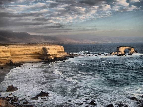
LA PORTADA
Located 16 km to the north of Antofagasta. It is located in the Cordillera de la Costa, by the sea. The access is by the route 1, up to the Km 20 continuing for a secondary road in a 2 km tract, both passable during the whole year. It has a surface of 31.27 hectares and an average altitude of 50 m. over the sea level. It is characterized to present moderate and homogeneous temperatures during the year, with a minimum temperature of 55º F and the maximum of 69º F. The relative humidity is high. Fauna: the cliff and arch is place for the nesting of the piquero, the “nun” gull and “guano” birds. They are also posts for the guanay duck and the pelican. In the coastal sector there are gulls, chorlos, “playeros”, and occasionally little partridges. Among the mammals the most important are the chungungo or two-hair sea otter, and other smaller cetaceans as the common dolphin and the striped dolphin.
The base of the relief is constituted by volcanic rocks of the rocky formation La Negra, from the Jurassic period (150 million years ago) on which the sedimentary rocks of the formation La Portada are leant. Its age goes back to 35 to 1 million years ago. This natural sculpture is considered Natural Monument.
HORNITOS
It is located 36 km to the north of Mejillones. It owes its name to the high temperatures of the place (between 77º and 83º F), which allows the access during the whole year. It has a longitude of 5 km in sheltered bay and with fine sand, what makes one of the best beaches. Health resort that has an extensive beach of fine sand and scarce swell. It is surrounded by cliffs that give it a visual frame and a climate of high temperatures. The tranquility of its waters makes it apt for the swimming, nautical sports and bank fishing. JUAN LÓPEZ It is located 38 km to the north of Antofagasta. Health resort of approximately 1 km. of extension, of fine sand and protected from the wind. It owes its name to the first resident of the costs of Antofagasta. The spa is located by the Cerro Moreno and -due to its calm waters- it is apt for the swimming and nautical sports. Next to it there are diverse archaeological places of communities that lived there approximately 5,000 years ago. It has a special régime of clouds called “camanchaca” -occasional coastal fog that is characteristic of the northern coast. MEJILLONES It is located 65 km to the north of Antofagasta. Bay that has a beach of soft swell. It is apt for all type of nautical sports. You can be taught about the forms of cholgas, choros and oysters cultivation, and you can taste the fish and shellfish. The bay is calm, apt for the fishing, the diving and the submarine hunting. It covers 20 km long approximately for 9 m. wide; its bottom is rock-free and its waters are calm and warm. The albacora or sword fish is one of the main species that you can obtain in this beach.
DESERT
VALLE DE LA LUNA (VALLEY OF MOON)
It is located 13 km to the northwest of San Pedro of Atacama.
It belongs to the National Reservation Los Flamencos. The valley has as morphology a curious similarity with the lunar landscape. For this reason it has taken the same name.
Geologic sight located at 2,600 m. over the sea level, belonging to the Cordillera de la Sal. The saline material that composes this mountain chain is very susceptible to erosion and to be dragged by the wind and other atmospheric agents. These have originated different and winding forms that characterize this area. It is also one of the places where the desert has its biggest rigorousness, since in the whole area there are no evidences of humidity, vegetable or animal life, which make it the most inhospitable place in the Earth, looking like a moon landscape.
HISTORICAL PLACES AND NATIONAL MONUMENTS
CHURCH SAN FRANCISCO DE CHIUCHIU
Declared National Monument in 1951.
Located 30 km to the northeast of Calama.
Declared National Monument for their architectural lines and for being one of the oldest in the country, since its construction dates from beginnings of the XVII century. Its structure is of a single deck, its interior is sober and it has valuable samples of colonial art.
CHURCH AND CAMPANARIO DE CASPANA
Declared National Monument in 1951.
Construction declared National Monument for their architectural lines and for the antiquity of its construction that dates approximately from 1641. Located at the end of the town, dominating the ravine and the village. It is of a single lengthened deck of about 20 for 40 m., with walls of stone stuck with cement, plastered with mud and whitened with lime; the structure of the roof is made of cactus wood and straw.
CHURCH OF SAN PEDRO DE ATACAMA
Declared National Monument in 1951.
Located to a side of the square.
Built around 1745. It is characterized to be simple and sober, presenting an architectural unit made in stone and plastered adobe. The structure of the roof is made of chañar wood and carob tree.
PUKARÁ DE LASANA
Declared National Monument in 1981.
It is located 8 km to the north of ChiuChiu.
This old indigenous fortress was built in the XII century, and is one of the most important relics in the Atacama cultural area of Chile. For this reason it has been declared National Monument.
It is a vestige of what was a fortified village lifted on high lands -valley of Lasana-, where the villagers lived and worked always attentive and protected. This area was dominated by the Inca, achieving a great empire. The Inca Tupác Yupanqui had reached these territories about 50 years before the arrival of the Spanish, imposing its own system of life.
PUKARÁ DE QUITOR
This is a pre-Inca construction of the XII century that is located 3 km to the north of San Pedro of Atacama and that -due to its age and importance- has been declared National Monument.
It was built with stones that climb a hill as a fortress with a perimetric defensive wall. It is located in a corner of the ravine where the river San Pedro or Río Grande flows. Right there, on a pronounced slope, you can find the ruins of Pukará de Quitor. It takes its name from the pre-Hispanic agrarian grouping, the “Ayllu of Quitor” which cultivation fields are next to the Pucará Quitor fortress. This fort was built during the XII century, as an answer to the expansionary designs of the aymara neighbours. In Quitor all the constructions are made of stone, generally not hewn and extracted from the liparita bank.
The housings and their small enclosed silo, the defensive enclosures that are noticed in the periphery and attributed to the same defensive wall, the enclosures that store grains and the watchtowers, complete 160 all together in a surface of 2.5 hectares. A great part of this hillside has a height of 70 meters, counted from its contiguous base to the cultivation fields until its ending point. The roofs are always one-sided, plane or with very little inclination. The same techniques have been both in Quitor and Lasana: chañar beams or carob tree, branches, and Ichu straw covered with mud.
PUEBLO ABIERTO DE PEINE
Declared National Monument in 1982.
It is located 102 km to the south of San Pedro of Atacama.
In the north margin of the ravine of Salar de Atacama you can find the ruins of the pre-Hispanic open town of Peine, and in front of this -in the south hillside of the same ravine- the new town of Peine, lifted during the XVII century and that was crossed by the Camino del Inca.
These open towns also called “old ports”, correspond to a period previous to the construction of the pukaras -lifted in the course of the XII century in the valleys of Salado river and Salar de Atacama. These “pukaras” were built next to the slopes of water with the purpose of developing their organization based on an agrarian, self-sufficiency economy. This is already reflected in the equivalence of size of the community fields no longer for cultivation or shepherding. The built area reaches 80 to 200 m. The roofs of the constructions are flat with little inclination, rafters, branches, straw and mud.
OFICINA SALITRERA CHACABUCO (SALTPETER OFFICE)
Declared National Monument in 1971.
Located approximately 200 km to the south of Antofagasta.
This office used to support a population of around 1,700 people, covering a surface of 37 hectares. Its equipment included a hospital, school, grocer s shop, mail, hotel, sport courts, theater, etc.
Its production capacity reached the 15,000 tons monthly of saltpeter.
It was restored with German government s funds in 1972.
RUINS OF HUANCHACA IN ANTOFAGASTA
Declared National Monument in 1974.
Located between the avenues Angamos and Argentina.
Declared National Monument for being one of the biggest silver foundries installed in South America towards 1878. It is a stone structure that looks like a great fortress. From its summit you can appreciate a panoramic view of Antofagasta.
CUSTOMS ANTOFAGASTA
Declared National Monument in 1976.
Located in 2786th, Balmaceda street.
Built in 1888. The structure is divided with walls based on diagonal pillars of oregon-type pine. There are rafters made of the same wood type, small beams and “tijerales” of the roof. Currently it is the headquarters of the Regional Museum.
SQUARE JOSÉ FRANCISCO VERGARA
Declared National Monument in 1980.
Located in the Campus of the Universidad de Antofagasta.
Accurate testimony of the past mining gest of the Oficina Salitrera Vergara. The square has four octagonal wooden arbors, fourteen floral trays, bushes and trees, and a central kiosk.
Rivers and Waterfalls
RÍO LOA
It is the longest river in Chile. Its origin is located in the Andes and after traveling for approximately 430 km, it ends in the sea -Caleta Loa, reference point to indicate the limit with the I Region of Tarapacá. Of snowy regime that ends in the sea. Its extensive journey in “U” shape waters part of the valleys, creating small oasis like the Lasana, Calama and Quillagua, among others. Chiu Chiu is the first town you find down by the river.
OJO DE OPACHE
It is located 14 km to the west of Calama. Health resort located in the vicinity of the Loa, and which waters are flooded into a natural pool surrounded by vegetation. The easy access is carried out, after passing a cascade, jump of water that forms a puddle apt for the swimming. The coast is even -approximately 600 m. The flora is given by the chañares and tamarugos; the fauna is mainly formed by families of rodents and little birds of the area (turtledoves, goldfinches, and thrushes, among others). Religious places
CHIU CHIU
It is located 35 km to the northeast of Calama. Although the contour of this town has an idyllic place of green shepherding lowlands which utilize the waters of the Loa. This river flows on a side of the oasis. Chiu Chiu s archaeological appeal also represents a tourist value. The town has one of the oldest churches in the country, built by the order of the conqueror Pedro de Valdivia. The religious party in adoration to San Francisco de Asís, every October 4th annually, is another attraction in the town. Near this town to about 4 km to the east, in a beautiful natural place, special for picnic and walks, a small lagoon of imaginative legends, called Lagoon of Chiu Chiu is located.” Near this town -in a beautiful place where you can make picnic and take walks- there is a small lagoon called Laguna de Chiu Chiu. It is located 4 km to the east of this settlement.
AYQUINA
Located 74 km to the east of Calama. The place is also known for its religious party of Nuestra Señora de Guadalupe de Ayquina. It is one of the most beautiful highland towns; entirely built in stone, with roofs of mud and straw, without eaves. The houses are all around the church which is placed in a depression that finishes in the viewpoint over the cliff of the Salado river. The town is almost uninhabited, with its doors closed with padlock; its population returns to the great celebration of the Virgen de Guadalupe, which is celebrated on September 7th and 8th. The town of Ayquina and the fields or immediate cultivation terraces were declared Typical Area in 1974.
CASPANA
It is located 83 km to the east of Calama. This town is located 3,260 m. over the sea level in the hillside of Caspana ravine. Its few inhabitants -supplementing the work of the land- are devoted in their majority to the craftsmanship in wool and volcanic stone. Andean town of paved sidewalks of typical Inca characteristics; its church dates from 1641. In this church religious parties take place, especially La Candelaria (February 2nd) and others that gather pilgrims of the surroundings. Its inhabitants are devoted to the agriculture, which cultivation made in terraces, produce a varied agriculture -products that are marketed in Calama or in Bolivian territory.
Thermal baths
TERMAS DE PURITAMA
It is located 27 km to the northeast of San Pedro of Atacama. Source of thermal water with constant fluids between 78º and 87º F, with healing properties for rheumatic illnesses. This sector is located on the way to the Geysers of the Tatio, in an abrupt ravine with vegetation and a puddle of 8 m. of diameter approximately. It has been formed by the affluence of tempered internal waters at the temperature of 87º F. The medicinal properties of the water are ideal for the treatment of rheumatism and muscular pains.
Folklore
SAN PEDRO DE ATACAMA
It is located 105 km to the southeast of Calama. This area was already inhabited about 11,000 years ago, and it is also registered that around the year 1535 it was pass of the Spanish that went to the south. It is an eminently rural commune, with scarce population that live dispersed in several villages and towns, living among the pre-mountain range, Salar de Atacama and La Punta de Atacama. San Pedro of Atacama -capital of the commune- is located 2,400 m. over the sea level and it stands out both for his architectural beauty and the archaeological value that it has. In 1980 it was declared Typical Area. It presents narrow streets delineated by the adobe constructions. Its small and imposing church was declared National Monument; the square is shading by very old molles. Near the square, the Jesuit Gustavo Le Paige built the celebrated Archaeological and Ethnographic Museum.
SOCAIRE
It is located 90 km to the southeast of San Pedro of Atacama. Town located in the eastern limit of the Salar de Atacama, next to the Andean mountain and which main activities are the agriculture, stockbreeding and craftsmanship. The 3,218 m. over the sea level permit to obtain an impressive view of the Salar de Atacama. It is a town that still preserve old traditions; this is how artisans of the place carry out varied and well knitted pieces in camelid (llama) and sheep wool, in spite of the primitive elements used in their making. The church of Socaire -with its Spanish style- is one of the elements that still preserve its historical origin, since in its interior it has old images and pictures of the colonial time. They develop traditional cultivation like vegetables, alfalfa, maize and wheat.
TOCONAO
It is located 38 km to the south of San Pedro of Atacama. Colonial town entirely built with liparita stones of volcanic origin. It is recognized for its interesting handmade objects of the same material. The word toconao derives of the cunzo “toco” that means stone. Town located at 2,500 m. over the sea level. The main source of work for its inhabitants is based on the agricultural and craftsmanship activities. These activities take place in the quarry of volcanic stone, giving origin to replicas of the Torre Campanario of the church present in this town. It is also known for the orchards alleys. In the surroundings you can find the Quebrada de Jeréz, with prehistoric stone engravings (petroglyphs).
City
ANTOFAGASTA
It is located 1,361 km to the north of Santiago. One of the main cities in the north of Chile -located in the coastal border-, with good infrastructure, services and varied tourist attractions both cultural and natural. The city has a pleasant climate during the whole year -refreshed by the soft sea breeze-, fluctuating between the 55º and 75 º F, with scarce annual precipitation. The main activities of the inhabitants are linked to the mining, the fishing, port activities and services. Also important are the intellectual activity, education and investigation developed in the university and technological field; its museums are dedicated to the anthropology, archaeology and geology -very important fields in this city. It has an active commercial and industrial center. The attractions are mainly located in this place, the historical neighborhood where you can appreciate diverse national monuments. On Grecia and Ejército avenues there are many green areas, spas, restaurants and diverse services next to the Pacific Ocean. There are some beaches inside the urban radius. One of the main ones is the Municipal Health Resort.
CALAMA
It is located 215 km to the northeast of Antofagasta. Calama is the capital of the Province of Loa. It is a city of active trade, being the administrative and urban center of the county. Located 2,260 m. over the sea level. The tourist importance of the city lies in the natural and cultural resources. Among the most important natural resources you can find the Loa river and the use of its riversides and banks for the fishing, picnic and swimming. The Municipal Resort is formed by a small dam that holds the river, in such a way that gives origin to a lagoon or artificial pool. Very close to Calama, you can find the place denominated La Cascada, small waterfall that falls down a cliff of the Loa; special for picnic, you can also appreciate the Loa Park, with its Anthropological and Ethnographic Museum.
TOCOPILLA
It is located 188 km to the north of Antofagasta. The city was founded in 1843. Most of their constructions date from the time of the saltpeter peak; today it is an important center of services, mechanized port, modern fishing industry and active trade. The vegetation is formed by some types of cactus, mosses and bushes that grow in the coastal hills due to the fog. Some of the most common species are: the “docas”, pitch, cachiyuyo and chañar. Regarding the fauna there are pelicans, sea swallows and sea wolves. It is rich in fish, among which we can point out: sacalinos, scads, cojinovas and shellfish like “locos” and limpets. An interesting attraction is the coastal road that unites Tocopilla to the city of Antofagasta, due to the variety of landscapes that this place presents, the continental border of the Pacific Ocean.