XII Region: Main Cities
PUERTO NATALES
Located 254 km to the northeast of Punta Arenas.
Tourist and cattle-related center of the region. On its harbor you can see black-necked swans and gulls. Stockbreeding and tourism are the main activities in this region. It is the starting point to visit other places of the region, like the cave of the “milodón”, Torres del Paine National Park, Vestisqueros Balmaceda and Serrano, among others.
The city is connected to Argentine by Río Turbio, carboniferous city where a great part of the population of Puerto Natalina work at. Other attractions are the Casino of Puerto Natales, The Museo Municipal, the square, with the old locomotive used in the industrial plant Bories. In this place people would work with the earnings of the ranches in the splendor era of the Sociedad Ganadera of Tierra del Fuego, founded in the beginning of this century.
Puerto Natales was founded in 1911 and its population is 15,000 inhabitants.
PUNTA ARENAS
Located about 3,090 km to the south of Santiago.
It is a very important urban center. This is the starting point for commercial, cultural and social development that extends up to the territory of Magallanes.
Urban center located next to the Estrecho de Magallanes, on the peninsula of Brunwick.
Punta Arenas is the county town of the region of Magallanes, formerly known as Punta Arenosa –literal translation for “Sandy Point”. This name was given by J. Byron in the XVII century.
Some of its main attractions are the Museo Salesiano Mayorino Borgatello; the statue of the sheep keeper with his horse, dog and sheep; the cemetery; the Institute of the Patagonia –research center of history and resources of the region- and its museum; the municipal theatre; Muñoz Gamero Square, with the memorial dedicated to the discovery of the Estrecho de Magallanes; the duty-free zone, among others.
PORVENIR
Located 25 nautical miles to the east of Punta Arenas.
It is the county town. It became crowded in 1883 around the gold mine. Nowadays it has a rich historic past in its museums, monuments and houses from the beginning of the century.
Small town with almost 6,400 inhabitants; most of them come from the first Croatian families that arrived at the island in the last period of the past century, to work in the gold mine of Sierra Boquená.
San Francisco de Sales Temple –built by the Salesianos- is an historic building of this town.
Of great interest result the surroundings, with clear views of bays, lagoons and mountain chains, all of them with abundant flora and fauna. The monument to the pioneers and the Province Museum are some of the main attractions of this settlement.
PUERTO WILLIAMS
Located at the northern end of Navarino Island.
County town and port city with 1,800 inhabitants. It has an interesting museum. In the woods there are beautiful waterfalls, lakes and rivers apt to good fishing, plus a place inhabited by a group of Yaganes.
On the coast you can appreciate the prow of the “Yelchos” which in 1916 rescued the shipwrecked people of the English ship “Endurance” from Elefantes island. The ship had got caught in the ice of the Antarctic. You can also appreciate the Micalui, another ship that developed sovereignty duties for many years.
On a privileged place there is an inn. On your way to this establishment you can see Los Dientes de Navarino –sharp mountains of particular beauty.
The city was named after John Williams, the person who founded Fort Bulnes.
In this city you can visit: Martín Gusinde museum, Puerto Williams church, Primera Casa, Cerro La Bandera, Dientes de Navarino, Villa Ukika, and Caleta Mejillones, among other interesting places.
XII Region:Mountain Chain and Hills
MOUNTAIN CHAIN AND HILLS.
CERRO LA CRUZ
Located next to downtown of Punta Arenas. It offers a panoramic view of the city with their red, blue and yellow roofs. On the horizon you can see Tierra del Fuego, the Monte Sarmiento and the south area of the peninsula of Brunswick. You can also appreciate old sailing ships that have been beached there for decades.
CERRO SOMBRERO
Located 123 km northeast of Porvenir.
Residential center and of operational service of ENAP (national company of the petroleum) in Tierra del Fuego, with more than 150 houses and comfortable community facilities.
Located on an isolated hill that gave him their name, it was built in 1958. It has gym, tempered swimming pool and an impressive botanical garden of interior, cinema, church, hospital and an airport, plus maintenance service and cellars.
CERRO LA BANDERA
It is located in Island Navarino, Port Williams.
Strategic place of signaling of the national emblem.
It receives this name because on the top a Chilean flag put; it was easily visible from Puerto Williams. It is part from the itinerary to the Dientes de Navarino.
CERRO GUIDO-LA CUMBRE
Located 90 km to the northwest of Puerto Natales.
Sector of mountain range with pointed hills that give a singular characteristic to the whole area. It highlights inside the context of the county.
The sector Guido – La Cumbre is characterized for being an area of patagonic mountain range, in which you can appreciate Sierra Baguales -of basaltic formation- with pointed hills that contrast with the plain that surrounds its base.
The summits of the mountains in this sector are basaltic and pointed at the end, resembling funny forms as of cathedrals; the rocks are black.
Guido was an old ranch; its houses, large shacks of sheep shearing, shops, corrals, etc.; the whole area is related to cattle and a great number of stays concentrate there.
XII Region: Chilean Antartica

CHILEAN ANTARCTICA
It has a surface of 1,250,000 km square.
As last frontier it is the Chilean Antarctic Territory, with more than 30 million km. cubic of ice. It conforms the majestic icy continent, with their eternal nights in winter, but in summer the sun doesn t completely hide, turning the ice red at dusk, when the flora and fauna renovate its vital cycle and they get ready for another long night.
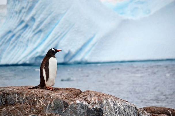
In its fauna you can appreciate species like the blue whale, sea elephants, seal of Weddell, antarctic wolf and different types of penguins such as the Adela, Papua, antarctic, and other birds like giant Petreles, cormoranes, antarctic doves and seabirds.
Chile maintains a villageof civil population in the white continent, plus 3 bases and 1 meteorological center, 1 investigation center and 4 refuges that operate in the summer.
This territory is of permanent scientific interest. The Antarctic Treaty -which includes 12 countries- establishes the use of the territory only with peaceful porpuse; therefore it excludes the experiments with nuclear weapons and it forbids the deposits of radio-active materials.
XII Region:Ski Centers
CERRO MIRADOR SKI CENTER
It is located 8 km to the west of Punta Arenas.
Place that shows one of the few ski courts with sea view. This recreational sport center has its higher point at 600 meters high and it is also an excellent viewpoint to see the Estrecho de Magallanes and Tierra del Fuego.
To arrive at their base you need to drive for approximately 30 minutes by car, from Muñoz Gamero Square, the main square of Punta Arenas. There are3 buses to transport people to the refuge on weekends.
The sportsmen can choose among 11 courts to slip; there are courts for all training level and they are mostly of medium level.
The snow has a special texture because of the wind, what gives it an attractive and singular characteristic for the practice of this sport. The courts are narrow and traced among trees increasing the degree of difficulty for the skier.
It has a double chair lift of 1,500 meters and a dragging rail. The refuge grants services of lease of teams, sleds, shop of repairs, wardrobes and lockers, skiing school with specialized monitors and patrols for the safety of the sportsmen. For those who don t practice this sport, we suggest to visit Cerro Mirador and relax with the beautiful view to the Estrecho de Magallanes, Tierra del Fuego and the most southern city in the continent.
XII Region: Gastronomy
Typical of this zone is the barbecued lamb. If you like sweet food you can choose from a huge variety of fruits such as calafate and ruibardo. Like in all the rest of the country here you can also eat the finnest sea food and fish such as ostiones, choritos, cholgas, pejerreyes, and the beatifull centolla, which is very similar to the crab.
XII Region:Islands and Archipelagoes
ISLANDS AND ARCHIPELAGOES
MAGDALENA ISLAND
It is located 25 miles to the north of Punta Arenas.
The island -in which northwest end has a lighthouse, next to Marta Island- is a natural haven of penguins, cormoranes, other birds and sea wolves. Both islands form Los Pingüinos Natural Monument that is located 25 nautical miles to the north of Punta Arenas.
It is estimated that the population of penguins reaches almost 50,000 couples of the Magallanes species.
TIERRA DEL FUEGO ISLAND
It is located to the east of Estrecho de Magallanes.
It is denominated this way due to the big bonfires that the navigators used to see when looking for whales or sea wolves in the costs. Its capital is Porvenir which became crowded in 1883. Porvenir City has oil plants. The island offers special places for fishing.
XII Region: Lakes and Lagoons
LAKES AND LAGOONS
FIGUEROA LAGOON
Located 17 km south of Torres del Paine. Its clear water –that reflects the hills of Sierra Montt- and its fauna are the main attractions of Figueroa Lagoon.
It is a small lagoon of clear water, located next to Route 9 which leads to Castillo hill and Torres del Paine National Park. The landscape is surrounded by high mountains and native forests. It is very common to see a wide variety of ovine fauna.
BALMACEDA LAKE
Located 31 km to the south of Puerto Natales.
It is a vast lake of clear, calm water which flows by Hollemberg river into Almirante Montt gulf. The lake presents excellent conditions for sport fishing, excursions, etc.
The access is through a coastal road that goes around Señoret canal and Almirante Montt gulf. It continues flowing through woods and beautiful landscapes. It has great conditions for salmon fishing.
BLANCO LAKE
Located 253 km southeast of Porvenir.
Sport fishermen usually visit this place because it is one of the lakes where brown and rainbow-type trouts are more abundant. It is surrounded by trees and you can also see the summit of the mountain chain of Tierra del Fuego. It has many different types of birds and beaches.
PEROÉ LAKE
Located 6 km to the north of the administrative office of Torres del Paine National Park.
This beautiful lake is the perfect visual scenario to appreciate Cuernos del Paine.
AZUL LAGOON
Located 20 km to the north of Sarmiento lake in Torres del Paine National Park.
It is a vast lagoon of blue water. From this place you an excellent view of Torres del Paine. The area is surrounded by mountains and native forests, with abundant flora and fauna.
PINTO LAKE
Located 34 km south of Puerto Natales.
It is a vast lake of clear, calm water that goes through a native forest with abundant flora and fauna.
The access is by a coastal road that goes around Señoret canal and Almirante Montt gulf. It continues to go through a native forest in which you can appreciate abundant flora and fauna.
There are some places for camping.
XII Region:Historic Places and National Monuments
HISTORIC PLACES AND NATIONAL MONUMENTS
FORT BULNES
Declared National Monument in 1968, it is located 60 km south of Punta Arenas.
It created the first Spanish colony on the coast of Estrecho de Magallanes. The currect fort is a historic reconstruction of the small fort where Chile established the first settlement in the Patagonia and took possession of the strait and neighboring lands (1843).
CAVE OF THE MILODÓN
It was declared National Monument in 1968
Located 150 km northwest of Puerto Natales.
In their interior rests of a gigantic prehistoric animal were found. In the entrance of the cave there is a replica of the milodón and an excellent museum.
Grotto that was formed for the erosion of the waves of the lake that flooded Puerto Natales, when the progressive retirement of the enormous icy block that stuffed it ocurred, during the last expansion of the quaternary glacier.
The rests of the milodón show and explain the formation of the cave and surroundings of this herbivore.
Signs of human population that would have lived approximately 11,000 years ago have been found inside the cave. The area of the cave is supplemented with a 50-m high crag denominated Silla del Diablo, and with some caverns of smaller dimensions called Cueva del medio y Cueva Chica
The cave of the milodón is located in the hillsides of Benítez Hill.
SARA BRAUN PALACE
It was declared National Monument in 1981.
Located in 716th, Muñoz Gamero Square.
This mansion from the XIX century belonged to Sara Braun -from Russia- who married the Portuguese José Nogueira, one of the pioneers in sheep breeding of Magallanes. At the moment of his death, this wealthy man left his wife a fortune. She administered this very well. In 1895 Mrs. Sara hired the French architect Numa Meyer to build the palace.
It is a two-story mansion. The front has a winter garden with a metallic structure.
ISLA MAGDALENA LIGHTHOUSE
This lighthouse was declared National Monument in 1976.
It is located in Isla Magdalena, 25 nautical miles to the north of Punta Arenas. Its surroundings are accompanied by birds colonies like cormoranes, penguins and some sea wolves.
MAURICIO BRAUN PALACE
It was declared National Monument in 1974.
It is located in 949th , Hernando de Magallanes street.
The palace belonged to Sara Braun’s youngest brother. Mr. Braun hired the French architect Antonio Beaulier to build the palace It was built in 1906.
This wealthy entrepreneur was stockbreeder, shipowner, banker. He also founded ranches, created a line of steamers, installed cold-storage rooms; he was linked to the whale and wood industry, gold and coal mine. He married Mrs. Josefina Menéndez Behety. The mansion also known as Braun-Menéndez houses the Historic Museum of Magallanes, inaugurated in 1983.
XII Region: National Parks
NATIONAL PARKS
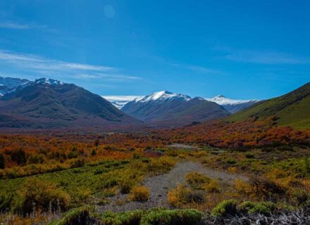
TORRES DEL PAINE NATIONAL PARK
It is located 250 km to the north of Punta Arenas and 125 km to the northwest of Puerto Natales.
Group of lakes, lagoons, rivers and snowdrifts of varied shades, of turquoise blue around a massif from which Torres de Granito and Cuernos del Paine emerge, produced by the glacial wear in an extensive pampas landscape.
It is located between the massif of Los Andes and the Patagonic steppe, covering a surface of 181,414 hectares.
Formed by an impressive Andean massif, surrounded by glaciers, waterfalls, lakes and lagoons. The conformation of the peaks of the massif impacts to every person who has had the opportunity to know it, giving its forms to the region from the beginning of the century.
It is constituted by several hills and typical geologic formations: Paine Chico (2,160 m), Paine Grande (3,050 m), and Paine Medio (2,670 m), being impressive in the context Las Torres del Paine; from south to north they are denominated: D Agostini, Central and Monzino. The impressive mountainous group is surrounded by numerous lakes, as the Grey, Pehoe, Toro, Sarmiento, Nordenjold, etc.
The flora is constituted mainly by lengas, ñirres, ciruelillos, caulker, sarsaparilla, etc.
In its wild fauna the most represented group is the “Avifauna”; here you can find 105 species. Among these you can find “anatidos”, little birds, shaves, herons, nandu, queltehue, owls and woodpeckers.
In mammals the most representative in the park is the guanaco which, next to two species of foxes, puma, huemul, and others are part of the 25 species of mammals present in the park.
The biggest scenic beauty is in the sectors: lake and glacier Grey, Salto Grande, Salto Chico, Paine mountain chain, and the base of Torres del Paine.
ALBERTO D’AGOSTINI NATIONAL PARK
It is located 80 nautical miles to the southeast of Punta Arenas.
Darwin mountain chain highlights in this place. It has a great number of glaciers and snowdrifts that go down by the hillsides of their mountains towards fiords, bays and canals.
Located in the south-western end of Tierra del Fuego. It has a surface of 1,460,000 hectares. In this park the spectacular Monte Sarmiento highlights, with its snowed summits. In its vicinities and skirting the park you can find the canal Beagle. In the area there are species like sea wolves, sea otters, better known as chungungos. In the suburbs you can see the glacier Marinelli which reaches 40 meters of altitude.
PALI-AIKE NATIONAL PARK
It is located 196 km northeast of Punta Arenas.
There are many volcanic cones of low height, natural caves, formations of lava, extensions and irregular ravines that look like the lunar landscape.
Also called “Escorial del Diablo”, it covers an extension of 5,030 hectares. It is located in the most arid section in the Magallanic steppe, in the commune of San Gregorio, county of Magallanes.
This area is settled in old scums of basaltic lava, what gives it a great archaeological importance.
The place is the natural residence of guanacos, foxes, armadillos, wild cats and bats, among others.
BERNARDO O’HIGGINS NATIONAL PARK
It is located to the northeast of Última Esperanza Province.
Because of its great quantity of canals and fiords, it is one of the most important wild areas in the region. The hanging glaciers Serrano and Balmaceda highlight because of their beauty.
It is one of the most vast parks in Chile (3,524,648 hectares). The access is by sea (from Puerto Natales) with 4 hours of sailing.
This park protects a spectacular landscape, remainder of the glacial era: the Patagonic south field of ice, one of the biggest fresh water reservations of the planet, formed 3.5 million years ago approximately.
The tourist activity is based on the exploitation of the glaciers Balmaceda and Serrano which are two hanging glaciers located in the basis of the mount Balmaceda (2,035 m. over the sea level). The glacier Balmaceda is located in the pending west of the hill and it deposits its floes directly in the fiord Última Esperanza. The Serrano is located in the hillside of Balmaceda hill and it deposits its floes in a lagoon.
In their vegetation we can find the peren-nifolio forest, dominated by always green trees, such as: coigüe, cinnamon tree, lenga and ñirre. The bushlike vegetation is presented by chilco, chaura, caulker, parilla, murtilla among the main ones. Another predominant element is the turba.
Its fauna is rich and varied: wolves, huemules, coipos, otters, cormoranes, ducks, eagles, condors, gulls, etc.
ALACALUFES NATIONAL RESERVATION
Located to the south of Estrecho de Magallanes.
It covers the western archipelagos and presents a landscape of low mountainous islands, with numerous canals and fiords. It was created in 1969.
The climate of the area corresponds to two types: climate temperate cold with great humidity and isothermic climate of tundras, with an annual thermal average of 45º F and 41.5º F, respectively. The precipitation is high, reaching 2.450 mm. annualy.
The vegetation includes coastal herborals and brushwoods, coigüe formations and turbal, while the fauna includes a great variety of birds and mammals.
It covers the four counties: Última Esperanza, Magallanes, Tierra del Fuego, and the Antarctica.
XII Region: Chilean Patagonia
Chilean Patagonia
Area that goes from the Estrecho de Magallanes to the south. The Patagonia in divided into Chilean territory and Argentine territory. It is characterized for having lower heights than the ones in the northern Andes, reaching 2,000 m of altitude. It has vast icy fields, glaciers, cold weather and much precipitation.
It became crowded in the second half of the XIX century with the concession of vast territorial extensions destined to sheep.
XII Region: Rivers and Waterfalls
RIVERS AND WATERFALLS
SERRANO RIVER
Located southwest of the administrative office of Torres del Paine National Park.
Vast lagoon with blue water, from which you can appreciate the magnificence of Torres del Paine. The area is surrounded by mountains and native forests with abundant flora and fauna.
GLACIERS
LAKE AND GLACIER GREY
Located 16 km to the north of the administrative office of Torres del Paine National Park.
The lake –with its emerald-colored water, floating ice floes, mountains and native forests- is one of the most impressive places in Torres del Paine.
GLACIER BALMACEDA
It is located in Bernardo O’Higgins National Park, at the end of Última Esperanza bay.
Its flora is formed by everlasting forests, in which the dominant species is the coigüe of Magallanes.
The access is by sea (navigation in motorboat) from Puerto Natales, passing through Última Esperanza bay.
FIORDS AND CANALS
PATAGONIC CANALS
Vast area that cover the entire insular part. It borders on the XI region through its great variety of canals, fiords, glaciers, bays and peninsulas. The southern canals spread out -from north to south- for over 1,600 km. Its weather and morphology are very intricate. There are two groups of canals. The first one is related to the archipelago of Chiloé and the second is related to the Patagonic canals of Magallanes. The peninsula of Taitao separates both groups of canals.
CANAL DE LAS MONTAÑAS
Located 55 nautical miles to the west of Puerto Natales.
Long, narrow bay surrounded by beautiful cliffs and waterfalls. It has a landscape of native forest.
The access begins by crossing Señoret canal and then entering Almirante Montt gulf; a detour towards Santa María canal permits to see the relief of Roca peninsula. The trip continues by crossing Morral Vicuña canal and then entering Las Montañas canal. This last canal is located between two mountain chains: Sarmiento on the west side and Riesco on the east side; they both belong to the Patagonic Andes.
BEAGLE CANAL
Located to the south of Tierra del Fuego island.
It is surrounded by a marvelous landscape with abundant vegetation on its banks and the everlasting regional fauna.
If the voyage is Beagle canal, you must take Magdalena canal, sail towards Brecknock peninsula through Cockburn canal, with its strong swell.
By sailing the Pacific -going around the National Park of Agostini- you can reach the route towards Beagle canal, surrounded by marvelous landscapes with abundant vegetation and fauna. This regional fauna is represented by sea wolves, the “chungungo” or otter, and some other animals that live in the fiords.
XII Region: Archeology
PALI-AIKE
Locatd 196 km northeast of Punta Arenas.
There are volcanic cones of low height, natural caves, formations of lava, extensions and irregular ravines that look like a lunar landscape.
Also called the “Escorial del Diablo”, it has an extension of 5,030 hectares. It is located in the most arid section of Magallanes steppe in the commune of San Gregorio, county of Magallanes
This area is located over old scraps of basaltic lava, what gives it a great archaeological importance. The place is natural residence of guanacos, foxes, armadillos, wild cats and bats among others.
CAVE OF THE MILODÓN
Located 25 km north of Puerto Natales.
In their interior rests of a gigantic prehistoric animal were found. In the entrance of the cave there is a replica of the milodón and an excellent museum.
Grotto that was formed for the erosion of the waves of the lake that flooded Puerto Natales, when the progressive retirement of the enormous icy block that stuffed it ocurred, during the last expansion of the quaternary glacier.
The rests of the milodón show and explain the formation of the cave and surroundings of this herbivore.
Signs of human population that would have lived approximately 11,000 years ago have been found inside the cave. The area of the cave is supplemented with a 50-m high crag denominated Silla del Diablo, and with some caverns of smaller dimensions called Cueva del medio y Cueva Chica
The cave of the milodón is located in the hillsides of Benítez Hill.