XI Region: Main cities
COYHAIQUE
Located at 1,649 km. south of Santiago. It is the capital of the region and it is placed on a beautiful valley of smooth hillocks between Simpson and Coyhaique rivers, and Divisadero hill on the south. A great deal of the economic activities of the region are concentrated in this city.
In native tongue its name means “village” or “camp between waters”. Founded on 12 of October, 1929, the city has discovered its own attractions since then, being of great importance due to the environmental conditions innate to the region, the raising of bovine and ovine. Its testimony is represented by a memorial to the hard working man as the shepherd. Its parade ground has a pentagonal shape and one can access to it through ten streets, contemplating the memorials to the pioneer and worthy of the country, General Bernardo O Higgins R.
PUERTO AYSÉN
Located at 67 km. northeast of Coyhaique.
It is the capital of the province and it is placed on the banks of Aysén river. From this point, the excursions to the main tourist attractions of the region, as Laguna San Rafael among others, have its departure.
The city is surrounded by mountains, standing out Marchant hill with a height of 1,204 m. Puerto Aysén has an abundant native vegetation, which in spring time present the flowering of Chilco, the “flower of the region”.
In the city one can find all the basic services and acts as the departure point for a number of tourist experiences across its beautiful surroundings, as: Riesco lake, 26 km. away; Chilconal hot springs, two hours away by sea across Aysén fiord; Los Palos lagoon, about 10 km. away to the north; Puerto Chacabuco, main port of Aysén Region, 14 km. away from Puerto Aysén. The big majority of the trips to San Rafael lagoon starts from this port, which take about 16 hours of navigation in a normal cruise.

CHILE CHICO
Placed on the south bank of General Carrera lake.
It resembles central zone because of its cultivated lands; besides, it has a microclimate.
Some interesting legends tell about a “war” that took place in 1918 between colonists and the police forces.
It is a town with 3.500 inhabitants approximately, and has big similitude to central zone because of its tree-lined walks created to protect from the wind. Facing the port, there are three small islands protecting the bay. In recent years, tourist services have remarkably increased, for now the city has six lodging establishments, two pubs, two discotheques and two cafes.
COCHRANE
Located at 334 km. south of Coyhaique.
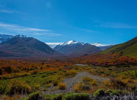
It is known by its cleanliness and deep heights relief, and wide valleys and pampas surrounding the city. Huemul and condor have found their refuge here. In the outskirts of the city it is possible to admire a scenery filled with a lot of rivers , from which stand out Baker, Cochrane, Neff and Salto Colonia rivers; in addition to those, one can find beautiful lakes as Brown, Esmeralda, Juncal, Vargas, Colonia and Cochrane, which present abundant salmony trouts. The nearest spots are “Tamango National Reserve”, situated at km south-east of Cochrane, in this rustic area is possible to find several communities of Huemules. San Lorenzo hill, located at 42 km. Southeast of Cochrane, with a height of 3,700 m., has abundant vegetation on its slopes, while its heights remain covered with snow throughout the year. Cochrane lake, located at 10 km. east of Cochrane, has a superficies of 17.375 km2. and it is one of the three binational lakes existing in the region.
XI Region: Archaeology
CUEVA DE LAS MANOS ARCHAEOLOGICAL SITE
It is located at 20 km. south of Chile Chico. It is a place of tourist interest and attraction, enhanced by the surrounding natural scenery. On its inside, a number of cave paintings can be found, with motives and styles of different spatial and chronological association, becoming one of the documents of the Patagonian cultural area. The cavern is situated on the northern slope of the hill that borders on the south side of Pedregoso river, which bed meets Jeinimeni river, in Chile Chico zone. This cave is located about 1,300 m. above sea level, 20 km. south of Chile Chico locality, on the way to Jeinimeni lagoon (X-75) until the crossing with Pedregoso river, point in which it is initiated the way up on foot. The site was discovered early in this century by German geologist Max Yunge and has been described by Hans Niemeyer (1980). The floor of the cave, however, is altered by the continuous visits of sheeps and the inhabitants, who have lighted fire and made clandestine excavations.
CUEVA DE LA GUANACA
It is located at 6 km west of Puerto Ibáñez. On its inside, among the cave figures, stands out one of a reddish pregnant guanaca and other figures of stylised men. Situated on the west side of Puerto Ibáñez, on the slope of the hill known by its rocky standing walls of dark colour, it is part of the chain projected to the south of Levica peninsula. The cave has a dimension of 18 m. in depth and an entrance of 6.8 m. in width by 4 m. in height, with an inclined roof descending to the bottom, due to the plunge of big lithic blocks of the upper standing walls of the hill, and it is placed in an area of open minor galleries, which allow a clear visibility of the entire down area of Río Ibánez.
XI Region: Austral highway
The execution tasks of this roadwork started in 1976, under the direction of Ministerio de Obras Públicas.
Its route spreads from Puerto Montt to Cochrane, totallizing 1,100 km. During the run, there must ferry across sea as well as lakes. The first cross by ferry takes place between Caleta La Arena and Puelche; the second one, between Pichanco and Leptepu; and the third one, between Puerto Ibáñez and Chile Chico.
The Austral Longitudinal Highway characterises for being a penetration path in a frame of abundant vegetation, crossing places where man still can act as an discover of uninhabited spots.
XI Region: Lakes and lagoons
LAGUNA FIGUEROA
Located 17 km south of Torres del Paine. Its clear water –that reflects the hills of Sierra Montt- and its fauna are the main attractions of Figueroa Lagoon.
It is a small lagoon of clear water, located next to Route 9 which leads to Castillo hill and Torres del Paine National Park. The landscape is surrounded by high mountains and native forests. It is very common to see a wide variety of ovine fauna.
LAGO BALMACEDA
Located 31 km to the south of Puerto Natales. It is a vast lake of clear, calm water which flows by Hollemberg river into Almirante Montt gulf. The lake presents excellent conditions for sport fishing, excursions, etc.
The access is through a coastal road that goes around Señoret canal and Almirante Montt gulf. It continues flowing through woods and beautiful landscapes. It has great conditions for salmon fishing.
LAGO BLANCO
Located 253 km southeast of Porvenir.
Sport fishermen usually visit this place because it is one of the lakes where brown and rainbow-type trouts are more abundant. It is surrounded by trees and you can also see the summit of the mountain chain of Tierra del Fuego. It has many different types of birds and beaches.
LAGO PEROÉ
Located 6 km to the north of the administrative office of Torres del Paine National Park.
This beautiful lake is the perfect visual scenario to appreciate Cuernos del Paine.
LAGUNA AZUL
Located 20 km to the north of Sarmiento lake in Torres del Paine National Park. It is a vast lagoon of blue water. From this place you an excellent view of Torres del Paine. The area is surrounded by mountains and native forests, with abundant flora and fauna.
LAGO PINTO
Located 34 km south of Puerto Natales.
It is a vast lake of clear, calm water that goes through a native forest with abundant flora and fauna.
The access is by a coastal road that goes around Señoret canal and Almirante Montt gulf. It continues to go through a native forest in which you can appreciate abundant flora and fauna.
There are some places for camping.
XI Region: Glaciars and snowdrifts
SAN RAFAEL SNOWDRIFT
Located at the east of San Rafael lagoon.
Embedded in Laguna San Rafael National Park, it represents the main tourist destination of Aysén region.
It has its origin in San Valentín mount and descends to the littoral with an expanse of 50 km. It has a lagoon source of 1,000 meters by 50 – 60 meters in height.
It constantly slides ice masses over the lagoon.
JORGE MONTT SNOWDRIFT
Situated to the south of Caleta Tortel – South Ice Fields – Baker Channel. This snowdrift presents a huge wall of bluish ice, which comes from South Ice Field. Its beauty exceeds any description.
The zone is mountainous with abundant vegetation and large rocky floored beaches.
This snowdrift, originated in South Ice Field, runs into Baker channel, which gives rise to a lot of huge bluish ice blocks, and is placed on the north-east border of Bernardo O Higgins National Park.
O HIGGINS SNOWDRIFT
Located to the south of Villa O Higgins.
With 8 km. in width and 150 meters in height, above lake water level, it is a place of a very beautiful view.
It is situated between South Ice Field and O Higgins lake.
XI Region: Lakes and lagoons
LAGUNA FIGUEROA
Located 17 km south of Torres del Paine. Its clear water –that reflects the hills of Sierra Montt- and its fauna are the main attractions of Figueroa Lagoon.
It is a small lagoon of clear water, located next to Route 9 which leads to Castillo hill and Torres del Paine National Park. The landscape is surrounded by high mountains and native forests. It is very common to see a wide variety of ovine fauna.
LAGO BALMACEDA
Located 31 km to the south of Puerto Natales. It is a vast lake of clear, calm water which flows by Hollemberg river into Almirante Montt gulf. The lake presents excellent conditions for sport fishing, excursions, etc.
The access is through a coastal road that goes around Señoret canal and Almirante Montt gulf. It continues flowing through woods and beautiful landscapes. It has great conditions for salmon fishing.
LAGO BLANCO
Located 253 km southeast of Porvenir.
Sport fishermen usually visit this place because it is one of the lakes where brown and rainbow-type trouts are more abundant. It is surrounded by trees and you can also see the summit of the mountain chain of Tierra del Fuego. It has many different types of birds and beaches.
LAGO PEROÉ
Located 6 km to the north of the administrative office of Torres del Paine National Park.
This beautiful lake is the perfect visual scenario to appreciate Cuernos del Paine.
LAGUNA AZUL
Located 20 km to the north of Sarmiento lake in Torres del Paine National Park. It is a vast lagoon of blue water. From this place you an excellent view of Torres del Paine. The area is surrounded by mountains and native forests, with abundant flora and fauna.
LAGO PINTO
Located 34 km south of Puerto Natales.
It is a vast lake of clear, calm water that goes through a native forest with abundant flora and fauna.
The access is by a coastal road that goes around Señoret canal and Almirante Montt gulf. It continues to go through a native forest in which you can appreciate abundant flora and fauna.
There are some places for camping.
XI Region: Ski Centers
CERRO MIRADOR SKI CENTER
It is located 8 km to the west of Punta Arenas.
Place that shows one of the few ski courts with sea view. This recreational sport center has its higher point at 600 meters high and it is also an excellent viewpoint to see the Estrecho de Magallanes and Tierra del Fuego.
To arrive at their base you need to drive for approximately 30 minutes by car, from Muñoz Gamero Square, the main square of Punta Arenas. There are3 buses to transport people to the refuge on weekends.
The sportsmen can choose among 11 courts to slip; there are courts for all training level and they are mostly of medium level.
The snow has a special texture because of the wind, what gives it an attractive and singular characteristic for the practice of this sport. The courts are narrow and traced among trees increasing the degree of difficulty for the skier.
It has a double chair lift of 1,500 meters and a dragging rail. The refuge grants services of lease of teams, sleds, shop of repairs, wardrobes and lockers, skiing school with specialized monitors and patrols for the safety of the sportsmen. For those who don t practice this sport, we suggest to visit Cerro Mirador and relax with the beautiful view to the Estrecho de Magallanes, Tierra del Fuego and the most southern city in the continent.
XI Region: National park
TORRES DEL PAINE NATIONAL PARK
It is located 250 km to the north of Punta Arenas and 125 km to the northwest of Puerto Natales.
Group of lakes, lagoons, rivers and snowdrifts of varied shades, of turquoise blue around a massif from which Torres de Granito and Cuernos del Paine emerge, produced by the glacial wear in an extensive pampas landscape.
It is located between the massif of Los Andes and the Patagonic steppe, covering a surface of 181,414 hectares.
Formed by an impressive Andean massif, surrounded by glaciers, waterfalls, lakes and lagoons. The conformation of the peaks of the massif impacts to every person who has had the opportunity to know it, giving its forms to the region from the beginning of the century.
It is constituted by several hills and typical geologic formations: Paine Chico (2,160 m), Paine Grande (3,050 m), and Paine Medio (2,670 m), being impressive in the context Las Torres del Paine; from south to north they are denominated: D Agostini, Central and Monzino. The impressive mountainous group is surrounded by numerous lakes, as the Grey, Pehoe, Toro, Sarmiento, Nordenjold, etc.
The flora is constituted mainly by lengas, ñirres, ciruelillos, caulker, sarsaparilla, etc.
In its wild fauna the most represented group is the “Avifauna”; here you can find 105 species. Among these you can find “anatidos”, little birds, shaves, herons, nandu, queltehue, owls and woodpeckers.
In mammals the most representative in the park is the guanaco which, next to two species of foxes, puma, huemul, and others are part of the 25 species of mammals present in the park.
The biggest scenic beauty is in the sectors: lake and glacier Grey, Salto Grande, Salto Chico, Paine mountain chain, and the base of Torres del Paine.
ALBERTO D’AGOSTINI NATIONAL PARK
It is located 80 nautical miles to the southeast of Punta Arenas.
Darwin mountain chain highlights in this place. It has a great number of glaciers and snowdrifts that go down by the hillsides of their mountains towards fiords, bays and canals.
Located in the south-western end of Tierra del Fuego. It has a surface of 1,460,000 hectares. In this park the spectacular Monte Sarmiento highlights, with its snowed summits. In its vicinities and skirting the park you can find the canal Beagle. In the area there are species like sea wolves, sea otters, better known as chungungos. In the suburbs you can see the glacier Marinelli which reaches 40 meters of altitude.
PALI-AIKE NATIONAL PARK
It is located 196 km northeast of Punta Arenas.
There are many volcanic cones of low height, natural caves, formations of lava, extensions and irregular ravines that look like the lunar landscape.
Also called “Escorial del Diablo”, it covers an extension of 5,030 hectares. It is located in the most arid section in the Magallanic steppe, in the commune of San Gregorio, county of Magallanes.
This area is settled in old scums of basaltic lava, what gives it a great archaeological importance.
The place is the natural residence of guanacos, foxes, armadillos, wild cats and bats, among others.
BERNARDO O’HIGGINS NATIONAL PARK
It is located to the northeast of Última Esperanza Province.
Because of its great quantity of canals and fiords, it is one of the most important wild areas in the region. The hanging glaciers Serrano and Balmaceda highlight because of their beauty.
It is one of the most vast parks in Chile (3,524,648 hectares). The access is by sea (from Puerto Natales) with 4 hours of sailing.
This park protects a spectacular landscape, remainder of the glacial era: the Patagonic south field of ice, one of the biggest fresh water reservations of the planet, formed 3.5 million years ago approximately.
The tourist activity is based on the exploitation of the glaciers Balmaceda and Serrano which are two hanging glaciers located in the basis of the mount Balmaceda (2,035 m. over the sea level). The glacier Balmaceda is located in the pending west of the hill and it deposits its floes directly in the fiord Última Esperanza. The Serrano is located in the hillside of Balmaceda hill and it deposits its floes in a lagoon.
In their vegetation we can find the peren-nifolio forest, dominated by always green trees, such as: coigüe, cinnamon tree, lenga and ñirre. The bushlike vegetation is presented by chilco, chaura, caulker, parilla, murtilla among the main ones. Another predominant element is the turba.
Its fauna is rich and varied: wolves, huemules, coipos, otters, cormoranes, ducks, eagles, condors, gulls, etc.
ALACALUFES NATIONAL RESERVATION
Located to the south of Estrecho de Magallanes.
It covers the western archipelagos and presents a landscape of low mountainous islands, with numerous canals and fiords. It was created in 1969.
The climate of the area corresponds to two types: climate temperate cold with great humidity and isothermic climate of tundras, with an annual thermal average of 45º F and 41.5º F, respectively. The precipitation is high, reaching 2.450 mm. annualy.
The vegetation includes coastal herborals and brushwoods, coigüe formations and turbal, while the fauna includes a great variety of birds and mammals.
It covers the four counties: Última Esperanza, Magallanes, Tierra del Fuego, and the Antarctica.
XI Region: Rivers and Waterfalls
RIVERS AND WATERFALLS
SERRANO RIVER
Located southwest of the administrative office of Torres del Paine National Park.
Vast lagoon with blue water, from which you can appreciate the magnificence of Torres del Paine. The area is surrounded by mountains and native forests with abundant flora and fauna.
Glaciers
LAKE AND GLACIER GREY
Located 16 km to the north of the administrative office of Torres del Paine National Park.
The lake –with its emerald-colored water, floating ice floes, mountains and native forests- is one of the most impressive places in Torres del Paine.
GLACIER BALMACEDA
It is located in Bernardo O’Higgins National Park, at the end of Última Esperanza bay.
Its flora is formed by everlasting forests, in which the dominant species is the coigüe of Magallanes.
The access is by sea (navigation in motorboat) from Puerto Natales, passing through Última Esperanza bay.
Fiords and canals
PATAGONIC CANALS
Vast area that cover the entire insular part. It borders on the XI region through its great variety of canals, fiords, glaciers, bays and peninsulas. The southern canals spread out -from north to south- for over 1,600 km. Its weather and morphology are very intricate. There are two groups of canals. The first one is related to the archipelago of Chiloé and the second is related to the Patagonic canals of Magallanes. The peninsula of Taitao separates both groups of canals.
CANAL DE LAS MONTAÑAS
Located 55 nautical miles to the west of Puerto Natales.
Long, narrow bay surrounded by beautiful cliffs and waterfalls. It has a landscape of native forest.
The access begins by crossing Señoret canal and then entering Almirante Montt gulf; a detour towards Santa María canal permits to see the relief of Roca peninsula. The trip continues by crossing Morral Vicuña canal and then entering Las Montañas canal. This last canal is located between two mountain chains: Sarmiento on the west side and Riesco on the east side; they both belong to the Patagonic Andes.
BEAGLE CANAL
Located to the south of Tierra del Fuego island.
It is surrounded by a marvelous landscape with abundant vegetation on its banks and the everlasting regional fauna.
If the voyage is Beagle canal, you must take Magdalena canal, sail towards Brecknock peninsula through Cockburn canal, with its strong swell.
By sailing the Pacific -going around the National Park of Agostini- you can reach the route towards Beagle canal, surrounded by marvelous landscapes with abundant vegetation and fauna. This regional fauna is represented by sea wolves, the “chungungo” or otter, and some other animals that live in the fiords.
Adventure Tourism
ADVENTURE TOURISM
QUEULAT NATIONAL PARK
Location and access: at 180 km. north of Coyhaique city via Austral Highway. One can practice climbing, trekking and hiking activities on suitable paths through native vegetation, glaciers and snowdrifts as Queulat hanging snowdrift.
PUERTO CISNES
Location and access: at 140 km. north of Coyhaique city via Austral Highway. Small town which in its surroundings offers the possibility of going into a jungle scenery to do trekking, hiking, horse riding, and climbing activities; besides, at Cisnes river one can practice rafting and kayak in rapids level 3.
LAGUNA SAN RAFAEL NATIONAL PARK
Location and access: from 1 to 7 days by sea to the south of Coyhaique. Also by plane. This national park has 1,742,000 hectares. In the lagoon of the same name one can watch its floating ice floes, San Valentín glacier and the fall of its ices. One can access to it by plane or sea via the channels and West Patagon archipelago, which invite to mountaineers and climbers to go around its eternal snow peaks as well as to tour around the park itself, which presents a variety of species of flora and fauna.
BAKER RIVER
Location and access: at 10 km. north-east of Cochrane and about 290 km. away from Puerto Bertrand.
Far to the south, one can appreciate the turquoise waters, excellent rapids, scenery longed for world-wide rafting, and a landscape that mixes with General Carrera lake view at the border with Argentina. Moreover, it offers a tour by Marble Caverns, top practice speleology, since its strange shapes. This river offers a wonderful adventure to whom are willing to go down rapids up to 5 level.