The commune of Putre forms part of the Province of Parinacota, in the first region of Tarapacá. The northern limit is the commune General Lagos; the western limit is the communes of Arica and Camarones; the southern limit is commune of Colchane and the eastern limit is Bolivia. Its surface is 6,061 km square and according to the census of 1992, the population is 2,803 inhabitants, with a density of 0.5 inhabitants per km square. Its main locations are Putre, Zapahuira, Murmuntani, Chapiquiña, Pachama, Belén, Lupica, Saxamar, Ticnamar and Socoroma.
On the high plateau we can find Chucuyo, Parinacota, Caquena and Guallatire.
ROUTES AND DISTANCES:
Attractions for tourists in the commune of Putre:
Nevados de Putre: the volcanoes Tarapaca and Ancoma form this mountain massif near Putre. It is 5,500 m. high over the sea level. The access can be by walking or with 4 wheel-drive vehicles using the route A-3 that surrounds the volcano Tarapaca.
Alero de Vilacaurani: eave with a huge exposed panel with cave paintings. Shapes painted on the surface of eaves and caves to represent humans, animals y some geometric shapes. For this purpose the artists used pigments of iron oxide mixed with some agglutinant substances. They show camelids and felines in a very natural style; humans, on the other hand, are very schematic. The drawings painted over the rock have suffered serious damage. However, they still preserve their quality of pre-historic art, and their meaning still remains a secret.
It is the most popular place with rock art in the area. The only disadvantage is that it is too far from Putre, and its partial destruction.
It is located to the west of Putre, near Lluta Valley, approximately at 3,600 m. of altitude. It is two to three hours far from Putre. The track that goes around the Quebrada de Putre is apt to go on foot, on a horse or mule.
Alero de Incani: it is a cave of regular proportions (8x5x5 m). Inside you can appreciate shapes of camelids painted in red, white and black. Some of the shapes are very natural and some are schematic. The cave is located two and a half hours -by horse- northwest from Putre.
Volcán Tarapaca Sanctuary: it is a sanctuary from the INCA period, in which interior a little human-shaped idol was found. It was made in a sacred material called “mullu”. It is located on the top of the volcano Tarapaca; you can get there on foot.
Feria Regional Andina: the most important agricultural, cattle-related, mining-related, handmade and folkloric fair in the I region. It takes place every October in Putre.
Putre Town: it is the capital of the commune since 1979 and capital of the province since 1982. It was meant to be a town for the Spanish community in charge of the commerce between Potosí and Arica.
FOOD AND LODGING:
Rosamel Restaurant: 15 tables for 60 people, 3 triple rooms.
La Paloma Restaurant: 25 tables for 100 people, 12 rooms.
Birding A. Andino Lodging: 299th, Baquedano; 6 beds and kitchen.
Las Vicuñas Inn: 3 stars, offers partial board values.
TAMBO QUEMADO TOWN
As a testimony of the historic importance of this place, a great variety of architectonic items and elements are still preserved in good shape. Many of these are made in stone. Some of them are fronts, sills, corner pillars, pavement on the streets some benches at O’Higgins street and some bars of fine wrought iron. Many of these items can be mistakenly considered as made at the end of the XVII century or beginning of the XVIII century because of their characteristics.
If you observe very carefully the primitive distribution of the population, you can see that it is mostly located in two main streets: O’Higgins and Baquedano. The Spanish influence appears with the construction of the church.
The city has 1,203 habitants and approximately 300 houses. The main attractions are the cobbled streets, cultivation terraces, the church and some houses that still preserve carved porches and lintels.
It is located at 3,500 m. over the sea level and 145 km. from Arica. You can get there by using the route Ch-11 (Arica-Tambo Quemado) and detour route A-147 (Cross route Ch-11-Putre).
Iurasi Spa: canalized springs; one of them goes to a well in the open air (Iurasi I) and the other goes to a hut with a pool (Iurasi II). They correspond to thermal water and people ascribes this water the capacity to cure them from different illnesses. It is located 3 km from the international road to Tambo Quemado.
The temperature of the water is between 120° F and 125° F, while the annual average weather is 50° F.
It is located 10 km west of Putre, at 4,000 m over the sea level. You can get there by using the route Ch-11 (Arica-Tambo Quemado) and detour of 3 km by the northwest hillside of the ravine.
MAIN ATTRACTIONS OF PUTRE
Putre Church
built in 1670 to replace the first one, destroyed by an earthquake. According to feature writers, it was covered with gold and silver. Of great proportions, similar to the ones in Socoroma, one deck, adobe walls with the exception of the frontal one that is made of stone.
Lauca National Park
it belongs to the World Net of Reservations of the Biosphere, with 137,883 hectares.
The most frequent flora is there, from the 3,200 to the 3,800 m. of altitude. In ravines and hillsides you can find forests of Queñoa, Chastudo, Guacaya, Perrito, Puscaya, Tola, Chilca and Tola Supu, while in the high plateau -over the 3,800 m.- there are two types of meadow: dry land and humid, formed by species like Tuna, Llareta, Queñoa of altitude, Paja Brava, Chachacoma and Bofedal.
Birds and mammals are the most important resource in this park due to their great variety and quantity. There are more than 130 species of birds. The most common are: Ñandú, Perdiz de la Puna, Blanquillo, Huairavo, Chilean Flamenco, Guallata or Ganzo, Pato Juarjual, Tagua Gigante, Pato Jergón, Pato Puna and the Cóndor. The most common mammals are: Guanaco, Vicuña, Alpaca, Taruca, Puma and Zorro.
Regarding the relief, the volcanic forms are the dominant ones reaching the 6,000 m. The principal volcanoes are: Parinacota, Pomerape, Guallatire, Acotango. On the high plateau it is important to point out the presence of two other volcanoes: Ajota and Tejene, plus some lava fields like the Cotacotani.
Of great importance are the hydro flows of the national park, where you can admire rivers Lauca and Lluta. The first has interior drain -Copaisa salar, in Bolivia- and the second flows into the Pacific Ocean in Arica. You can also find two lakes: Cotacotani and Chungará.
It shows desert climate with rains in summer -sleet- and snow in winter. The average annual precipitation is 280 mm, and the average temperature goes from 52° F to 68° F in daylight and 35° F to 14° F during the night.
The cultural attractions are very important in the national park, covering an area of long cultural traditions that began 3,000 years ago after hunters and collectors walked through this zone for 7,000 years. As a proof of this you can visit the fossil shelters found in the area denominated Las Cuevas (The Caves). They were probably constructed 9,000 years ago and they correspond to rests of shelters left on the eaves of the area. Among the historic places it is important to detach the church and town of Chucuyo, Estancias de Chungará, Ajata and Cruzane.
The anthropologic aspects are represented in the indigenous communities of Chucuyo and Parinacota.
You can get there using the international route Ch-11 (Arica-Tambo Quemado). It is located 192 km from Arica. Its altitude goes from 3,200 m to 6,342 m over the sea level.
Socoroma
it was used by the Spanish on its way to the high plateau. The urban shape still remains and the constructions are in good shape and some streets are made of stone pavement. The city is strategically located in the ravine of the same name. You can appreciate the different cultivation terraces from the ravine. Important are the crops of oregano and alfalfa, and the old eucalyptus in the surrounding of the city.
It is located in the commune of Putre, at 3,000 m of altitude, 125 km from Arica and 30 km. from the commune capital. You can get there using the route Ch-11 and detour on route A-216 to Socoroma.
Church of Socoroma: built in 1560, it is an impressive building. It only has one deck, adobe walls with the exception of the front which is made of stone. It was restored in 1883, with the construction of the front wall and the tower.
Housing and feeding: Mrs. Emilia Humire. Address: behind the school. Daily menu, 3 beds.
Tambo de Zapahuira
architectonic complex, typical from Inca settlements. It is formed by two extreme “wings”, with rectangular, well-distributed places destined for administration. There is also a central area with circular precincts for domestic purposes. The corners of these precincts show the mooring techniques utilized to join the converging walls, which increases the resistance of the constructions.
The different styles of ceramic go from “high plateau” (Saxamar style), Inka and domestic.
This is one of the biggest and complex inns of the Inca age in Parinacota. Constantly in preservation, the place has been utilized as corral. For this purpose the original plant has suffered some changes. This place has a great potential for cultural tourism. The high plateau has not been added to the tours yet.
Portezuelo de Chapiquiña
it is the entrance of the high plateau. The view is astonishing. The place signals the geographic division between pre-mountain chain and the high plateau in the commune of Putre. You can get there using the route Ch-11 and detour on route A-201, ex international road to Bolivia.
Church of Pachama
probably built in the XVII century. It has one deck and two lateral chapels with adobe walls. On its longitudinal walls there are frescos and paintings with strong colors (San Jorge and San Cristóbal allegories from the XVIII century). Its entrance hall is made of stone.
Ticnamar Viejo Town
Old abandoned town of the XVII century that was dragged by Ticnamar River one August 15th, day of the employer party of the town, Virgen de Asunta. Later on it was rebuilt becoming a town dedicated mainly to oregano cultivations and medic.
Located at 3,100 m over the sea level, 167 km from Arica and 92 km from the county town. The access is through the Route Ch-11 (Arica-Tambo Quemado) and detours on route A-35 in the area of Zapahuira.
Belén Church
Built probably at the end of the XVIII century; it has a main deck with adobe walls. Its altarpiece is made up of valuable fragments of carved wood (probably from the old church).
Its main cover of carved stone is the most valuable in the region; it is completely figured, with salomonic circular pilasters, dice, cornice, figures ,etc. Its isolated tower presents its adobe base and superior stone part, which has three brass bells.
Belén is located 133 km from Arica and 77 kms from Putre. Its access is through longitudinal crossing of route Ch-11 in the sector of Zapahuira with route A-35 south direction. It is at 3,240 m over thesea level.
Lodging and feeding
Mrs. María Martínez, daily menu, Gral. Lagos (in route to Lupica) abd San Martin; it has 2 beds for lodging.
Termas de Chitune
hypothermal source qualifiable as medicinal mineral water for their high content of arsenic, despite it overcomes the limit of this element for watering water; it presents a better aptitude for this purpose. The temperature of the water is almost 85 Fahrenheit degress and the average annual environment temperature is of 50 degre; the climate of the area in which is is marginal desert of height. The access is very difficult and it does not have any infraestructure.
Located in the town of Saxamar at 3,100 m over the sea level, 86 km from Putre and 162 km fromArica in the south hillside of the ravine of Saxamar. The access is by the route Ch-11 and detours in longitudinal crossing, route A-35 in the sector of Zapahuira, toward Belén and Codpa.
Church of Ticnamar
original construction probably of the XVII or XVIII century; it has been restored. It consists of a ship and two chapels, adobe walls. In its moment its roof was covered with straw over mats and cane, with figured wooden “tijerales”, with the exception of the chapels, where the primitive beams of coirón have been preserved. Their stone cover is embedded to the heading wall with two salomonic columns, dice, cornice, etc. Its adobe tower is separated from the church, with 3 brass bells, forming the access square. The group is beautiful and it is one of the most valuable in the area, which can become a great attraction in Ticnamar Town. It is 167 km from Arica and 102 km from Putre. The access is by longitudinal crossing of route Ch-11 in the sector of Zapahuira with route A-35 with south direction going to Nativity and Codpa. It is 3,100 m. over the sea level.
Pampa Chucuyo
High plateau location that presents a great variety of vegetable species and animals, such as many vicuñas easily noticeable from the highway Ch-11 Arica – Tambo Quemado.
Alero de las Cuevas
it is part of a series of eaves inventoried in the district of Las Cuevas. The eaves N° 1 has the best conditions for the human occupation because of its width. It presents the oldest evidences hunters/collectors in the high plateau of the Province of Parinacota, dated among 9500 – 8000. The place was used until Inca time. The other eaves present archaeological deposits of smaller temporary covering.
The eaves N° 1 is located on the base of a natural wall that surrounds a marsh or bofedal. In this place There is a number of vicuñas and it was surely what attracted the Andean hunters. Archaeological excavations allowed to recover a series of instruments for hunting and cuting up, plus bones of animals (i.e. camelids, vizcacha). Of the place only the eaves is preserved, since the archaeological deposit was removed of the cave to set a stable. Nevertheless, the place can be marked as one of the oldest settlements of hunters in the area.
It is located a few meters from the international highway Arica-Tambo Quemado and to the north of the refuge Las Cuevas of CONAF. When entering from the refuge you must walk for about 10 to 15 minutes, for a sandy surface covered with straw and other bushes.
Chacu de Las Cuevas
The chacu or sleeve for the capture of vicuñas was built with a “pirca” of liparitic volcanic stone slabs of about 100 m long and 30 to 40 m wide. It is located strategically in the hillside of a small ravine, reason why it cannot be noticed by the animals that come from the neighboring pampas. The widest part in the funnel of the sleeve is located in the intersection area of the ravine and the pampas, leaving the pirca almost at the level of the floor. The walls become higher and more convergent in the bottom of the ravine, ending up in a circular corral. The animals were spurred on for the pampas towards the sector where the sleeve was located and there they were penned to be sacrificed or sheared. This technique was broadly described by columnists (i.e. Garcilaso de la Vega). The place was restored by the CONAF on the late seventies. Originally the walls had collapsed for the effect of earthquakes.
It is located to the southeast of the refuge of Conaf in Las Cuevas. The access is through the route Ch-11 (Arica-Tambo Quemado) and walking for 5 to 10 minutes for a track towards the south.
Town of Chucuyo
Old town of pre-Columbian origin which historical importance resides in being an important point in the intense caravan traffic of the XVI and XVII centuries among the auriferous mine of Potosí towards the port of Arica. There are three restaurants and a center of textiles in alpaca wool. It is located 4,300 m. over the sea level, at 179 km from Arica and 37 km from the communal capital. The access is by for the route Ch-11 (Arica-Tambo Quemado).
Las Cuevas Thermal baths
It corresponds to a hypothermic spring that could be qualified as drinkable mineral water, but due to its high arsenic content it should be considered as medicinal mineral water. The content in boron and its qualification C3 – S1 reduce its agricultural suitability, being able only to be used with recreational purposes. Its tourist potentiality is good since it is very close to the international road Ch-11 (Arica-Tambo Quemado), near Putre and other towns.
The temperature of the water is of 89ºF with an average of annual environmental temperature of 40ºF and a pH in Situ of 7,45. Its waters fill a small pool of concrete; the place is influenced by a high-steppe climate. However -for its direct recreational use- it is necessary to eliminate the arsenic that appears on the surface.
Located to the west side of the refuge of Conaf and the south side of the route Ch-11 (Arica-Tambo Quemado) in the sector denominated Las Cuevas, 20 km from Putre 4,300 m. over the sea level.
Sector Las Cuevas: In this place you can observe the great extension of the bofedal and the rocky formations where small birds can be observed. You can also see rodents and especially a number of viscachas, next to the nursery of Conaf, located in the same sector. It is 162 km from Arica, at 4,200 m. of altitude. The access is by route Ch-11 (Arica-Tambo Quemado).
Choquelimpie Mine
Old silver mine that accomplished an important role in the history of the mining of the area. Today it is out of order, and represents a testimony of the productive activity in the area. Located 3,100 m. over the sea level, and distant 167 km from Arica and 92 km from the communal capital. The access is by route Ch-11 (Arica-Tambo Quemado) and detours on route A-35 in the sector of Zapahuira.
Lauca River
Important to be sustenance of great part of the ecosystem in the high plateau. On its journey you can appreciate a great flora variety and typical fauna of the area. The ” Lauca ” has a endorreic drainage system that flows from south to east, with drainage in the Salar de Coipasa in Bolivia; its surface is 2,350 km square.Its origin is the river drain that comes from Cotacotani lagoon.
It covers the National Park Lauca, where it feeds the bofedal of Parinacota. It also covers The National Reservation LasVicuñas. The access is by route Ch-11 (Arica-Tambo Quemado).
COMMUNE OF PARINACOTA:
Located at the border of the bofedal of Parinacota. Of pre-Columbian origin, with a certain development in the Hispanic time as support point of the big droves on their traffic to the highland. It is observed that the urban layout has surrounded the church with its processional streets. Distant 180 km from Arica, of easy access through the route Ch-11 (Arica-Tambo Quemado).
Lodging:
There are two refuges of the administration of Conaf. These have two
houses
with basic equipment.
Parinacota Town: in this town you can find the administration of the park, center of environmental information. On the outskirts of the town there are interpretive paths, picnic area, lodging for visitors (5 beds), information.
Chungara nursery, picnic area (6 places), camping site area (2 places), hygienic service, information.

MAIN ATTRACTIONS OF PARINACOTA
Bofedal of Parinacota: Bofedal of non saline type. It presents a diversity of 16 vegetable species and among the predominant animals there are small birds, bigger birds and mammals. In this group you can find the camelid livestock -characteristic of the highland area.
Santuario de Altura of Cerro Guane Guane
Wall that defines a semicircle which served to stop the strong winds and as viewpoint lifted on the summit of the hill, from where you can appreciate the basin of the Parinacota. It possibly served to ceremonies and rituals linked to the gods or guardian spirits who reside in the hills that surround the town. Typical of the Andean culture until the present. No devices have been found.
Located between Parinacota and Caquena, to the northwest of the town of Parinacota, on the summit of Cerro Guane Guane, at 4,800 m. of altitude. The access from the town of Parinacota -that is 184 km from Arica and 36 km from Putre- is by route Ch-11(Arica-Tambo Quemado) and it detours on route A-123 (Parinacota-Visviri).
Lake Chungará
It has a surface of 21,5 kms square and with a maximum depth of 33 m. in the proximities of Ajata, being the rivers Chungará and Sopocalane its main tributaries. The existent avifauna and the landscape that surrounds it are very imppresive, with imposing summits and plains of great beauty. It certainly is the most outstanding attraction in the National Park Lauca, because of the interest that causes to visit the lake.
Located 4,517 m. over the sea level, in the commune of Putre inside the National Park Lauca. It is located 192 km from Arica and the access is by route Ch-11 Arica-Tambo Quemado.
Lagoons Cotacotani
Formed by four lagoons of different sizes, connected by channels and natural lowlands that have a surface of 6 kms square; these have the river Benedicto Morales and El Encuentro estuary which discharge gives origin to the river Desaguadero, pouring its waters in the marshes of Parinacota where river Lauca begins. Their main attractions are the flora and existent fauna, plus the landscape component which is of great interest. The access is by route Ch-11 (Arica-Tambo Quemado), apt to be covered by walking and to arrive until their banks by a path enabled from the nursery of Parinacota.
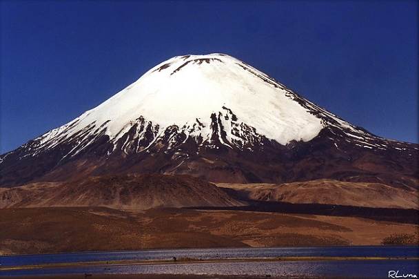
Nevados Payachatas
Snowy volcanoes formed by the Parinacota of 6,342 m. of altitude and the Pomerape, with 6,282 m. of altitude, both created in the quaternary era. The hillsides of both volcanoes have a soft slope, not overcoming the 45º of inclination. This last characteristic implies that many foreign visitors arrive very excited to the National Park Lauca to practice scaling, especially between July and September. The average temperature in the base of the volcanoes goes from 33° F to 40° F. The highest temperatures reach 68º F, the average relative humidity is 40% and the annual precipitation is between 200 and 300 mm. Located in the National Park Lauca, in front of Lake Chungará, 192 km from Arica.
Church of Parinacota
The church of Parinacota (National Monument) is located in the middle of the town; it is surrounded by a stone wall stuccoed with mud and painted white of bofedal lime. The three doors of the wall are roofed with arches and crowned of rosy volcanic stone. A solid steeple is incorporated to one of its corners. The original church of the XVII century was reconstructed in stone in 1789 and whitened to the lime, with roofs of mud and straw. Their portal is made of carved stone. The interior walls of fresh saturated colors of the XVII century and colonial saints are in regular conditions.
The processions are made on the streets that surround the church, where the wells or altars dedicated to the images are still preserved. In front of the church there is a small square with benches and an arbor placed by a benefactor. It was declared National Monument on May 4th, 1979.
Bofedal of Caquena
Bofedal of non saline type that presents a low heterogeneity, a diversity of 18 vegetable species and inside the predominant animals there are small birds, bigger birds and mammals; in this group you can find the typical camelid livestock which is characteristic of the highland area.
Town of Caquena
Located beside the river Caquena to the north of Parinacota; of pre-Columbian origin, near the border with Bolivia and under the guardian custody of the Payachatas. The area is specially capable for the shepherding of the camelid livestock, reason why there is a hatchery for vicuñas -perhaps the only one in the world. Its houses are built with the typical architecture -with adobe walls and roofs of straw.
Located in the commune of Putre. It is 4,600 m. over the sea level, 207 km from Arica and 55 km from the communal capital. The access is by route Ch-11 (Arica-Tambo Quemado) and it detours on route A-123 (Parinacota – Visviri) and route A-119 (it crosses route A-123 in the area of Nasahuento – Caquena).
Caquena River
Main superficial course of the commune of General Lagos. It goes from south to north, and it starts in the northwest of the Nevados Payachatas -covering the border line between Chile and Bolivia. Its flow feeds the neighboring bofedales (Caquena, Nasahuento, Chujlluta) where different species of birds live and where the different camelid species pasture. It covers the commune of General Lagos, its origin is near the village of Caquena in the northwestern sector of the volcanoes Pomerape and Parinacota. The access is by route A-123; you can follow its course, by the deviation in the sector of the town of Parinacota in the km. 184 of the route Ch-11 (Arica-Tambo Quemado).
Cultivation of Trouts in Caquena
The cultivation of trouts is carried out in implemented pools and supervised by the Aymara community of the town of Caquena. The production of trouts is of the variety Rainbow or Trucha Salmonada, cultivated in places free of contamination in the highland sector of the county.
Church of Caquena
Original construction from the XVI century; it was restored in 1891. It is one of the oldest of the county of Parinacota. It is located in front of a wide open square and framed in their two sides by 2 ceremonial wells. It is a one-deck building, of adobe walls; its altarpiece is made of colored stone, its atrium is closed by a wall with portholes and with a tower incorporated to this. In its front there is a missal in sacristy from the year 1765.
Town of Misitune
Village of stone houses and adobe, next to the west riverbank of the bofedal that goes from north to south. The houses are located next to a series of blocks of solidified ash. It is a stay of shepherds (Quispe family) that share, without a lot of enthusiasm the bofedal with several dozens of vicuñas. Some things have been found: 1 tip of basalt projectile, 1 orange-red ceramic fragment and a Bolivian coin from 1936. The place could have been used in the Late Archaic period (6000 – 4000). Today it is altered by the current and past activities that have covered the prehispanic evidences. Located in the route to Guallatire, the access is by route A-235 and it detours on route A-231 towards the town. It is 200 km from Arica.
Colonial Trapiche of Guallatire
Facilities of a genius of colonial time for the prosecution and foundry of silver minerals. Composed by a mill (to mill the mineral through stone molars hydraulically moved), remains of the canal, courts for the storing of minerals, foundry ovens, dependences for domestic use, etc. Most of the buildings are in ruins, although well stabilized. It is located 89 km to the north of Guallatire, 4,300 m. over the sea level. The access is by route A-235 (Puente Lauca – Guallatire).
Town of Viluvio
village of aymara shepherds near river Ancuta, next to which there is a long bofedal with different species. Among its fauna you can see vicuñas and suris. Located to the south of the town of Guallatire, which is 41 km from Putre. The access is by route Ch-11 (Arica-Tambo Quemado) and it detours on route A-235.
Village of Ancuta
Old village of aymara shepherds with six constructions, a great corral and a small church, which give the group the typical structure of highland village. Located towards the town of Guallatire, 210 km from Arica. The access is by route A-235 (Puente Lauca – Guallatire).
Town of Guallatire
Old town of pre-Columbian origin; with 50 housings built in adobe stone and straw, established in narrow back streets and colored with white lime. It is located 3,100 m. over the sea level, distant 167 km from Arica and 92 km from the communal capital. The access is by route Ch-11 (Arica – Tambo Quemado) and it detours on route A-35 in sector of Zapahuira.
Volcano Guallatire
With an altitude of 6,060 m; it is the only one in activity inside the region of Tarapacá, reason why it is possible to appreciate the fumaroles thrown out from their snowed summit. Located to the northwest of Guallatire, 230 km from Arica; the access is by route Ch-11 (Arica -Tambo Quemado) and it detours on route A-235 (Puente Lauca – Guallatire).
Church of Japu
Located on the height above the village level. Construction original from the XVIII century -of stone and mud- with floor of stone slab; the wall that contains the small atrium is made of stone and mud, too. It does not have a tower. It is located in the village of Japu, which in the highland and near the frontier with Bolivia. It has approximately twenty housings temporarily used and located in the basis of the hill, protected from the wind, in front of the bofedal where the livestock pastures. It is in the commune of Putre, near the town of Guallatire (21 km), at 4,260 m. over the sea level). Distant 250 km from Arica and 100 km from Putre.
The access is by detour to route A-235 towards Guallatire, from route Ch-11 (Arica – Tambo Quemado).
Church of Guallatire
Construction original from the XVII century; it is facing the volcano Guallatire. Its construction is made of stone and mud, with atrium and slender tower incorporated to the external wall. It has been restored several times, being the last time in 1940. There are four ceremonial stations in the neighboring hills. Located in the town of Guallatire, distant 235 km from Arica and 81km from Putre. It is at 4,260 m. of altitude in the commune of Putre. The access is by deviation to route A-235 in the sector of Chucuyo, from route Ch-11.
National Reservation Las Vicuñas
With a surface of 209,131 hectares, it presents diverse natural attractions, like the different vegetable formations denominated Pajonales, Bofedal, Tolar, Llaretal, and forests of Queñoa. There is a diverse fauna composed by mammals as: Quirquincho of the Puna, Guinea Pig of the Puna, Chingue Real, Puma, Gato Colorado and Vicuña. Among the birds, you can appreciate the Condor, Kiula or Perdíz, Pato Juarjual, Aguilucho, Cojón and Pitío of the Puna. There are also amphibians as the Sapo de Rulo, Sapo, Sapito de Cuatro Ojos and diverse species of lizards among the reptiles.
On its relief it presents formations with heights over the 5,000 m. of altitude, among which you can find the following hills and volcanoes: Puquintica, Aritinca, Salle, Belén and Anocariri.
Inside its hydrography they highlight the rivers Lauca and Guallatire, as well as the lagoons Paquisa. Their cultural attractiveness are represented by archaeological places as Sanctuaries of Height and some Apachetas; there are anthropological aspects present and belonging to aymara communities dedicated to the shepherding of llamas and alpacas in a hemi-nomadic way, using diverse villages alternatingly occupied. Located in the commune of Putre, at 4,300 m. of altitude, distant 230 km from Arica. The access is by route A-235 (Puente Lauca – Guallatire – Chilcaya).
Bofedal of Chilcaya
Bofedal of saline type; it presents a low heterogeneity, a diversity of 7 vegetable species and inside the predominant animals there are small birds, bigger birds and mammals. In this group you can find the camelid livestock which is characteristic of the highland area. Located in the north entrance of the Salar of Surire, distant 285 km from Arica, with an altitude of 4,200 m. over the sea level. The access is by two national routes: A-235 (Puente Lauca – Guallatire – Chilcaya) from international route Ch-11 (Arica – Tambo Quemado), and route A-31.
Town of Surire
Town composed for more than 20 rectangular structures of stone masonry; located on the hillside of one of the hills that surround the “salar” in a tolar vegetational environment. The place was occupied from Late Intermediate era until colonial times. Located in the south border of the Salar of Surire, distant 285 km from Arica, with an altitude of 4,200 m. over the sea level. The access is by two national routes: A-235 (Puente Lauca – Guallatire – Chilcaya) from international route Ch-11 (Arica – Tambo Quemado) and route A-31.
Quiborax Mine
Mining project that extracts the salts of borax which are abundant in the salares of the I region. The extractive system is developed manually to select the material, by using heavy machinery for the works of internal loading, transport, process and storage of ulexita in ground. The mineral is processed in the treatment plant located in the km 70 of the route Arica – La Paz, in the county of Arica. The extraction plants are located in the Salar of Surire, in the western sector of the current territory of the salar. It is 270 km from Arica and the access is by route Ch-11 (Arica – Tambo Quemado) and route A-235 (Puente Lauca – Guallatire – Chilcaya).
Salar of Surire
It has an approximate surface of 15,858 hectares which originally belonged to the Protected Area of the National Park Lauca. In the year 1983, after the redemarkation of this park, the salar was reclassified and partially declared Natural Monument Salar of Surire, with a surface of 11,298 hectares -under protection, education and investigation conditions- and another part for mining use with a surface of 4,560 hectares.
One of the most important resources in the monument regarding the fauna is the presence of three species of flamingos, of the six existent in the world: Chilean flamenco, Parina Grande, Parina Chica or Flamenco de James. Great quantity of vicuñas, as well as Suris or Nandu of the Puna can also be observed, from the pampas and bofedales that surround the salar.
Regarding the presence of vegetation in the pampas and surrounding hillsides of the Salar, it is important to mention the following species: Paja Brava, Llaretilla, Pasto Vicuñero, Tola and Chachacoma.
On its relief, the predominant height is the hill Oquealla that reaches 4,322 m. over the sea level. Its hydrography is represented by rivers Surire or Casisane and Río Blanco. Distant 285 km from Arica, with an altitude of 4,200 m. over the sea level, the access is by two national routes: A-235 (Puente Lauca – Guallatire – Chilcaya) from international route Ch-11 (Arica – Tambo Quemado) and route A-31.
Thermal baths of Polloquere
It corresponds to a hyperthermic source classified as medicinal mineral water, evaluated as not apt for drinking, minimum possibilities for watering and recreation of direct contact. The temperature of its waters is approximately 142º F and the pH in laboratory is 7.4. Its appeal is the outcrop to the surface, presenting a lagoon-like aspect. The area in which it is located presents the climate of steppe of height. Located inside the perimeters of the Natural Monument Salar of Surire, on the southern sector. It is 270 km from Arica; the access is by route Ch-11 (Arica – Tambo Quemado) and it detours on route A-235 (Puente Lauca – Guallatire – Chilcaya).
Sector Lagunas Salar of Surire
Of great scientific interest for being area where the flamingos nest, in which you can appreciate three of the six existent species of flamingos: the Chilean Flamenco, Andean Flamenco and Flamenco de James. Located in the western sector of the Natural Monument Salar of Surire, distant 270 km from Arica, at 4,200 m. over the sea level. The access is by route Ch-11 (Arica-Tambo Quemado) and it detours on route A-235 (Guallatire – Chilcaya).