OJOS DEL SALADO
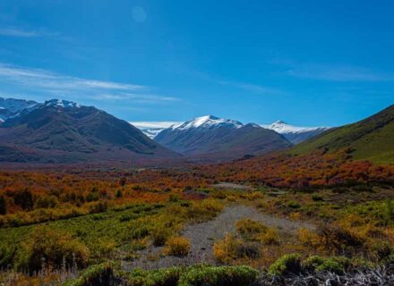
Location and access: 270 km. east of Copiapó, by an unpaved, irregular, slow-speed road. You can get access to the world s highest active volcano (6,893 m. above sea level) from Copiapó, then you have to go through the desert and the pre-Cordillera area. It is not a big challenge to climb this volcano, but acclimatization is strongly advised. This can be previously achieved by visiting other outstanding sections of this zone, like the enormous, white and isolated Maricunga Salt Deposit (3,750 m. above sea level), where you can find lakes that shelter flamingo flocks. In the midst of a high mountain tops landscape, you can also find Pedernales Salt Deposit, which can be reached climbed by climbing the Cordillera of Claudio Gay. You can also visit Santa Rosa and Negro Francisco Lagoons, which are situated in Nevado Tres Cruces National Park. These lagoons shelter an abundant fauna of Cordillera flamingos. This places are unmatched. Trekking, off-road and mountain climbing can be practiced here.

PAN DE AZÚCAR NATIONAL PARK
Location and access: 30 km. north of Chañaral, specifically in the coastal zone.
You can visit this park during the whole year. Trekking and eco-tourist activities can be practice in the gigantic coastal cliffs, where you can find penguins, marine wolves, chungungos, guanacos and foxes. The vegetation of this area is irrigated by the thick low-lying coastal fogs.
This zone is ideal for making expeditions in 4×4 vehicles, either through the high Cordillera depression (more than 10 salt deposits can be found in this place) or by the coastal area, where you can find vast sandy grounds and some little fishing ports. This is the most unreachable and unknown site of the country. The coastal desert area has an abundant flora and fauna, although some people say that vegetation is unmatched with that of southern ecosystems. Expeditions has to be carried out through the existing roads and traces in order to preserve the natural features of this zone, such as dunes, hills and plains.
FLORID DESERT
The section from Chañaral to La Ligua corresponds, from a bio-climatic point of view, to a transition area between the north desert and a strong zone of Mediterranean weather characterized by regular rain water in winter and a dry summer season. The typical vegetation corresponds to open thickets, low bushes, tapestries of grass in spring and a predominance of cactaceous vegetation.
If water rain exceeds the annual rate during winter season, this arid scenery turns into a unique spring landscape full of colors, in which thousands of seeds, bulbs and insects bloom out, amusing those tourists who witness such abundant and prosperous panorama. This phenomenon takes place between Copiapó and Vallenar, and also in those roads leading to Huasco, Carrizal Bajo and Totoral. Trekking and hiking are some sport activities that you can practice here. Scuba diving can also be practiced in the several beaches and bays distributed along the 500 km. of coastal zone
Beaches of Atacama
BEACHES III REGION
CISNE BAY
It is located in the southern coastal zone of Bahía Inglesa.
This paradisiacal whitish-sand beach is situated in the south side of Bahía Inglesa. It has neither tourist nor services facilities, therefore it is ideal for camping.
This plain, semicircular-shaped beach is 400 m. long. The motion of the waves and the wind are moderate. Rocky formations can be found in its ends.
It is undergoing an incipient tourist boom. Beach sports and fishing can be practiced here.
Due to the excellent weather conditions, this beach can be visited most part of the year.
SALADO BAY BEACH
It is located in the south border of the community of Caldera.
Salado Bay is a coastal geographical area that has a long, whitish and fine sand beach. The absence of tourist facilities, the beautiful beaches and the fishing conditions are some of its most remarkable characteristics.
This 2,000 m. long bay has deep, crystalline, warm waters (20ºC), which allow an excellent fishing activity.
The area has neither tourist nor service facilities. Some temporary fishing camps and marine cultivation devices can be sighted here.
The beaches are surrounded by dunes in which recreational activities can be practiced. Although the beach lacks of a strong tidal activity, there is a forceful marine undertow and a dominant south wind activity.
The access way is by 5 North Highway; 36 km. from Copiapó City.
RAMADA AND RODILLO BEACHES
They are located at 6 km. north of Caldera.
These almost plain, whitish-sand beaches are an exceptional place for recreation. Actually, Ramada and Rodillo Beaches are one single place; there are no partitions between them.
Ramada is an excellent place for beach activities and recreation. There is a smooth slope and warm, (18ºC – 20ºC) placid waters. It is approximately 2 km. long, and it can be visited by an internal road. There is a rocky formation in the north end of Ramada, which separates it from Rodillo. This beach has a more dynamic tidal activity and a higher slope. Here we can find several summer houses, which are currently undergoing improvement and regularization processes.
They lack of tourist or service facilities, however, every weekend their splendid characteristics attract many visitors.
PORTOFINO BEACH
It is located at 20 km. south of Chañaral.
Portofino is a vast coastal area, in which you can find small bays, small fishing ports situated in rocky places, fishing locations and swimming sites.
A little fishing port is located in a group of small bays, which are separated by rocky places. Portofino beach is approximately 60 m. long. It has whitish sand and crystalline, placid waters, due to the presence of rocks.
This place lacks of tourist and service facilities. A few summer cabins can be found here.
Thanks to the magnificent weather and beach conditions, this place can be visited in whatever season of the year.
BAHÍA INGLESA
It is located at 6 km. south of Caldera.
This bay of approximately 12 km. long has crystalline, turquoise waters and whitish-sand beaches, like Piscina Beach.
Piscina Beach is located in the north side of the Bay. Rocky formations have carved up little inlets where swimming can be practiced. We can also find other beaches: Las Machas, which is 2 km. long, and Rocas Negras, which is located south of Las Machas. They share some characteristics like whitish sand, a smooth slope and placid waters.
Piscina Beach has a residential area, where summer cabins, tourist equipment, hotels and various services can be found.
Temperature reaches 28º C during summertime and 14º C during wintertime.
TRES PLAYITAS BEACH
It is located in the north side of Huasco Port. Due to its fine sand, smooth slope and placid tidal activity, Tres Playitas is an excellent place for recreational activities.
You can get access to Tres Playitas by Huasco Bajo. You have to cross the Huasco River bridge and then go along an unpaved 15 km. coastal road
The beach is approximately 300 m. long and it is subdivided into three distinct beach sectors by rocky formations, thus the name of this place (“Three Little Beaches”).
The temperature reaches 20ºC during summertime. It has crystalline waters; fine, light-grey sand and a calm tidal and wind activity.
The vegetation is typical of that present in the coastal zone and in dune formations.
This beach lacks of tourist facilities and services, and fishing activities.
CALDERA
It is located at 75 km. northwest of Copiapó.
Caldera is the most important tourist city of the III Region. It has an integral and ample structure of tourist and services facilities. Among its geographical characteristics we find bays and excellent beaches, which constitute a coastal tourist center.
Wheelwright, the responsible for the construction of the first railway in 1849, suggested the initiative of changing the port facilities from Puerto Viejo to Caldera. Subsequently, Caldera became a municipality in 1855, then it became the most important port of the Region. Caldera is also one of the most important ports of the country.
Among its many attractions, we can mention the beautiful beaches, the port area, and the industrial activity, which is closely related to fishing and mining-port duties.
Caldera is a tourist center that is well-known throughout the country. Surrounding coastal zones like Bahía Inglesa, which is located at 6 km. south, can also be visited.
Lakes and Lagoons of Atacama
LAKES AND LAGOONS III REGION
NEGRO FRANCISCO LAGOON
It is located at 226 km. east of Copiapó.
This is a brackish lagoon that is situated at 4,126 m. above the sea level in the Cordillera, specifically at Nevado Tres Cruces National Park. In this area, high plateau fauna like parinas, vicuñas, guanacos and other species are kept under protection. Copiapó Volcano can be sighted from this place.
The surface of the lagoon is 860 km2. Two distinct areas can be identified in the Lagoon according to the salinity level.
Sparse vegetation can be found in this typical Andean environment. Here you can find a cabin and rangers from CONAF (Forestry National Association).
A special authorization must be granted to visit this Park, specifically for Marte Mine, whose access is currently closed down.
There are two roads that lead to this place. The main highway between Copiapó Province and Catamarca Province (Argentina) is C-31 International Road. You can also get to the south west side of Maricunga salt deposit by following the road leading to Ancho Valley until Pantanillo. Then, follow the road until Astaburuaga River rivulet which crosses Negro Francisco.
LAGUNA VERDE
It is located 265 km. northeast of Copiapó, only 21 km. away from the Argentinean frontier (in the border of Paso de San Francisco road).
This emerald-green water lagoon, which is situated in the Cordillera of Los Andes at 4,325 m. height above sea level, is surrounded by high mountain tops. In its south side we can find hot springs.
Volcanic activity of the area is confirmed by the geological traces present in both the hills and the surrounding area. It can be also corroborated by Ojos del Salado Volcano, whose last eruptive activity was in 1956.
In this place it is possible to practice mountain climbing and going into expeditions, keeping always in mind the necessary security measures.
SANTA ROSA LAGOON
It is located in the south side of Maricunga salt deposit.
This beautiful Cordillera lagoon shelters various bird species.
Paipote Rivulet C-341 road is the access way to this place. The existence of typical high-mountain vegetation (“bofedales”) allows the presence of birds, guanacos, parinas, among others animals.
A little CONAF shelter cabin, which lacks of potable water and restrooms, is located in the southwest area of the lagoon.
Although it is a much longer trip, the road leading to Maricunga Border Complex is another way of getting to Santa Rosa Lagoon.
SANTA JUANA DAMMING
It is located at 20 km. east of Vallenar.
This damming was built in 1995 to control Huasco Valley irrigation process. 160 millions m3 of water can be dammed up here, thanks to its gigantic retaining wall of 115 m. height.
Damming s flooding surface is 410 hectares. The lake stretches 10 km. when it reaches its maximum water level.
12,000 hectares of Huasco Valley are irrigated by this damming.
This enormous engineering construction relies on state-of-the-art technology. A comprehensive signal system allows a proper visit of the site.
LAUTARO “TRANQUE ” (ARTIFICIAL LAGOON)
It is located at 96 km. southeast of Copiapó.
This old and singular artificial lagoon was built in the 1920 s, in the Valley of Copiapó River. It still irrigates Copiapó Valley.
The damming controls the irrigation process of the Valley since 1930. Its water capacity was reduced to 27 millions m3. The well-known Amolanas aqueduct, which has been declared a National Monument, is situated in its wall.
Lautaro constitutes a recreational place for Atacama inhabitants. The access way to this site is a paved road that goes through vineyard areas and high mountain tops.
Gastronomy
GASTRONOMY III REGION
Basically, fish, seafood, and fruit grown in the Region (grapes, figs, avocados and olives).
Among its typical beverages, we can find “pajarete”, which is a sweet, golden-color wine, and pisco.
Folklore and Customs
FOLKLORE AND CUSTOMS
SAN FELIX
It is located at 25 km. south of Alto del Carmen.
In this place you can taste “pajarete”, which is a sweet, golden-color wine; and home-made pisco. Handcrafting and fruits like raisins, sun-dried peaches, nuts, avocados, figs, grapes, etc. are also available here.
Situated in the valley of El Carmen River in Huasco, San Felix is well-known for its architectural characteristics, the square and the rustic church.
The geographical scenery surrounded by mountains is an interesting area, while El Carmen River constitutes a recreational place.
The main characteristic of the village are the rustic constructions, whose structures are made of tar-covered wood, plastered with mud. The roofs are built with clay-coated cattail.
FREIRINA
It is located at 32 km. west of Vallenar.
Freirina is the capital of Huasco community and It is situated in the Huasco Valley. Last century distinctive architectural features and a natural environment coexists in this town, which offers a number of typical handcrafted products, olive trees, clay and cattail handcrafting, etc.
On April 8, 1824, the Administrative Authority of La Serena Municipality decided to name the city after the Supreme Director Ramón Freire.
The population of the town is about 5,000 inhabitants. Agricultural activities take place in several little parcels devoted to the cultivation of olives, vegetable growing and cattle breeding.
Colonial times architectural attributes can be distinctly identified in some National Buildings, such as Edificio Portales, with its centenary columns, which was built in 1870. Nowadays, it houses the Freirina Municipality. Another important building of the town is its solemn church, which is a reminder of a prosperity period experienced by the province due to the agricultural and mining activities. It was built in 1869.
In these days, olive processing activity (olive oil) and clay and cattail handcrafting have achieved a remarkable quality level well-known throughout the Region.
Other tourist attractions are: Torres de Labrar and the little port Chañaral, with its coastal sites.
Islands
ISLANDS III REGION
Due to its long and narrow geographical form, Chile has two relevant physical areas: Cordillera of Los Andes and the Pacific Ocean.
There are several islands along its coastal zone, especially in the southern section of the country.
Some of these islands are:
CHAÑARAL ISLAND
Chañaral Island can be reached from Chañaral little port, which is located southwest of Vallenar. The Island belongs to Pingüino de Humboldt National Reservation, where we can find groups of dolphins.
The entrance way to Chañaral little port is 5 North Route Pan-American Highway, after taking a 48 km. diversion road until Chañaral de Aceituna; you can also take an alternative way until Carrizalillo. This town is located at 12 km. away from Chañaral little port. Carrizalillo is an oasis where you can find olive trees, a school, a chapel (Lourdes Virgin festivity is held in this place for three days), a beach and a little fishermen port. Boats can be rented here to reach Chañaral Island. During this one hour excursion you can enjoy the company of groups of “pico de botella” (“bottle beaked”) dolphins swimming along the boat, which is a very rare phenomenon for this zone. Penguins, birds, seals and “lobos marinos” (Chilean seals) can also be found in this Island.