Our national geography offers a series of spots that invite us to grab our bag pack and immerse into the diverse natural landscapes that the country offers. This is the purpose of Sendero Chile, a governmental initiative that promotes tourism in the country through 50 trails properly set up. These trails are equipped with maps and access to particularly attractive and valuable heritage sites.
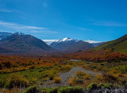
Miscanti Lake: A 100 km away from San Pedro de Atacama in the Antofagasta Region and in the middle of the desert, the Lejía Lake can be found. From this point departs a 25 km expedition that provides a view of volcanos and hills that acquire a red shade during sunset. This is a trekking at high altitude, over 4.000 meters in the high Andean plateau. On average, it takes an 11-hour walk to get to the Miscanti Lake. On the next day, one can ascend the 5.600 meters high hill of the Miscanti volcano, and after 7 arduous hours one can reach the top.
La Campana National Park: The Valparaiso region has a rich natural landscape where the sclerophyllous forest with abundant peumos, espinos and litres among others, converges with an area where the Chilean palma, Jubaea chilensis, blooms with 62 specimens that provide a unique geographical area. Among the trekking trails, the one that connects the Ocoa with the Granizo area stands out. A 6 hour walk provides a view to the valleys of the region and to the Andinista trail. The 8 hour roundtrip culminates at the top of La Campana hill with an impressive view of the Andes Mountain and the Pacific Ocean.
Yerba Loca Natural Sanctuary: Located at Exit/Curve 15 on the road to Farellones, only 25 km away from Santiago, this natural landscape of 39.000 hectares offers a 2 day walk to arrive to the beautiful hanging glacier “La Paloma”. The landscapes of the mountain range and the bird population of the area are the permanent view of the 15 km trekking.
Provincia Hill: Located at a 3.000 height over Lo Barnechea in Santiago, the Provincia hill is the most visited from the San Ramón range, integrated by the Tambor, Ramón and Punta de Damas hills as well. Of dried and arid land during most part of the year, from the top of Provincia Hill it is possible to see carrion birds and birds of prey like the condor or the marsh harrier. After a 5 or 6 hour walk, a unique panoramic view of the Santiago basin is attained.
Altos de Lircay: Especially famous lately, this nature reserve is located in the Maule slopes. The Valle Nevado trail stands out with its 17 km of extension that require a 3 or 4 day walk. Climb volcanic hillsides from which you can get great panoramic views and also reach natural thermal waters walking 10 km further.
Huerquehue National Park: Close to Pucón in the Araucanía region and in right before the Andes mountain range, this national park is famous in the area for its scenic beauty. Viewpoints, internal lakes and araucaria forests with a view to the Caburga lake are some of the features of this park and its 12.500 hectares that are a powerful attraction for the trekking enthusiasts.
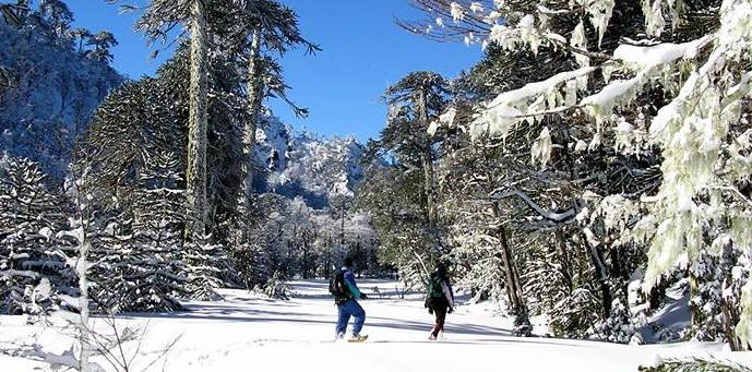
Villarica Volcano: This is a typical mountain trekking that requires ice axes and crampons. After a 5 hour climb, one arrives to the dome of the volcano that is still in activity. The view from the top is incomparable where the basins of the Lanín volcano and of the main lakes can be appreciated. The excursion requires a guide and one can descend sliding through the snow.
Jesuitas Route: This route takes you through the inner areas of a pristine valley with a length of about 70 km, which joins the Reloncaví estuary with the Todos los Santos lake and it reaches San Carlos de Bariloché in Argentina. The route starts at the point in which Los Jesuitas path was founded by the religious order in the 18th century while they were looking for a route of access to the zone of Nahuel-Huapi lake. There are points of unique beauty like Cayutué lake and the Tronador Volcano. The route requires a 10 day walk approximately.
Chiloé National Park: From the southern area there’s a beautiful 3-hour trekking across the Anay beach. It is one of the few points to observe the Pacific Ocean and its ferocity, while the lonely beach adjoins the native forest.
Torres del Paine: This is one of the most famous sites in Patagonia and year after year it seduces thousands of bag packers that enjoy trekking and wish to be in deep contact with the Patagonian nature.
El Grande and W, the top two routes of the park, offer a 4-day or a full-week walk with a unique view of the intricate Paine mountain range and the Patagonian ice field. Summer is the best time to embark on this voyage. Torres del Paine is one of the most beautiful places in Chile.
Dientes de Navarino: Nothing less than the most southern trekking in the world, this route has not been open for long but has gained popularity among those who enjoy adventure. With heights that ascend over the 1.000 meters, the mountains of the Navarino island are a permanent presence and their formation resemble a jaw gums made of snow. The trekking to its bottom takes 3 to 4 days, considering the physical conditions and patience of the person. One must pay attention to climate variability in the area.