X Region: Main cities
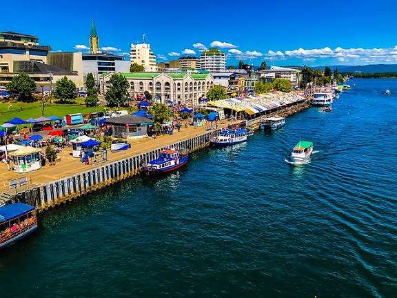
PUERTO MONTT
It is situated in a plain, at the sides of Seno de Reloncaví. Puerto Montt is the Capital of the X Region and a commercial and tourist center. It has an abundant marine fauna and a well-known typical gastronomy.
It was founded by Don Vicente Pérez Rosales on February 12, 1853, in the locality of Astilleros Melipulli. The city was named after Manuel Montt, the President of Chile at that time. Larch exploitation was the main economical activity of the inhabitants of this zone.
Puerto Montt has a population of 130,730. Due to its strategic location, interesting tourist expeditions can be made. Its maritime port connects it with Aysén and Magallanes Regions, while El Tepual International Airport connects it with the main air terminals of the country.
Ship or boat expeditions can be made from Puerto Montt. You can visit canals and nearby islands where you can find interesting natural attractions.
VALDIVIA
This beautiful city is located on the banks of Calle-Calle River. It is surrounded by several rivers and many tourist activities can be practiced here, such as: fluvial expeditions, water sports and events.
It still maintains some German traditions. This city has several sculptures.
Historical Sites and National Monuments.
Relevant Facts: Valdivia, the Capital of the Province, was founded on February 9, 1552, by the Spanish conqueror Don Pedro de Valdivia. For three centuries, this city was the most important Spanish bastion in South America. Valdivia had a powerful system of forts and castles located around the city and Corral Bay, as a protection against corsairs and the continuous attacks of the natives. German colonization of Los Lagos Region started in this city, in the middle of the last century (1850).
Tourist Sites:
Spanish fortified towers: It is still possible to sight traces of the Spanish colonial period (del Barro fortified towers and Los Canelos fortified tower) that date from 1774. Its main objective at that time was to defend and to guard the entrances and exists.
The Anniversary of the city is celebrated in February, with a week of artistic, cultural and sport events that represent the spirit of Valdivia inhabitants. The celebration concludes with “La Noche Valdiviana” (a typical Valdivia celebration), in which allegorically decorated boats parade along Calle-Calle and Valdivia Rivers. A phenomenal fireworks show is also held.
Avenida Costanera: Along this vast drive, you can see boats, green areas, gardens and beautiful residences. This is an ideal walking area both for the inhabitants of the city and tourists.

OSORNO
It is located at 105 km. north of Puerto Montt, which is the Capital of the Region.
You can access this city by 5 South Pan-American Highway.
Osorno is a connecting point with Bariloche City, in Argentina.
The city was founded in 1553 by Francisco de Villagra. It was originally named Santa Marina Ortíz de Gaete after Pedro de Valdivia s wife. Its main attractions are Plaza de Armas, with its multicolored-lighted water fountain and a cinnamon tree planted by Gabriela Mistral, the famous Chilean poetess, in 1938; San Mateo Cathedral; Santa Luisa Fort, which was built in 1793 during the third phase of the city s settlement. In 1796, it housed Governor Ambrosio O Higgins.
PUERTO VARAS
It is located at 20 km. north of Puerto Montt.
This is one of the main cities located at the banks of Llanquihue Lake. It is also known by the name of “The City of Roses”. It still maintains vestiges of the German colonization, such as the architectural characteristics of its houses and some familiar customs.
Puerto Varas City was founded in 1854 as a consequence of the German colonization, which was mainly promoted by the colonizing agent Don Vicente Pérez Rosales. Some other vestiges that still can be sighted are the well-kept gardens and the gastronomy.
This tourist center is located in a natural landscape, which is made up by Llanquihue Lake and Osorno and Calbuco Volcanoes. The city a has a diverse commercial activity, a casino, elegant hotels and restaurants, and tourist transportation services. From this place, you can make expeditions to Petrohué Falls, Todos los Santos Lake, Osorno Volcano, Peulla and even Bariloche City. You can access this city either by plane (El Tepual International Airport is situated at 35 km. from Puerto Montt) or bus by 5 Sur Road and also by Vicente Pérez Rosales International Passage (225 Road), which connects Puerto Varas with San Carlos de Bariloche in Argentina.
CASTRO
This is the Capital and also the Administrative Center of Chiloé. Castro was founded on February 12, 1567, by Don Martín Ruiz de Gamboa. You can get access to this place by bus. Buses depart from Ancud City, which is situated at 85 km. north of Castro.
Among Its many attractions, we can mention Castro market, where you can find handcrafting, native fruit and vegetables, and typical food.
The main architectural building material is wood. Handcrafting is very common in Chiloé, since this is how the people get their daily life objects.
Castro is one of the three oldest cities in Chile.
Every February, this city celebrates the traditional “Festival Costumbrista Chilote” (Chiloé s Customs Festival), in which handcrafting, folklore, gastronomy, traditional labors and typical Island customs are present.
CHAITÉN
This is the Capital and the Administrative Center of the Province. This port has hotels, restaurants, emergency services, mechanical workshops, communications, Banco del Estado offices, gas stations, etc. The city has an irregular design and wide streets.
With a rather recent history, Chaitén is the Capital of Palena Province since 1981. In 1933, it had only two or three houses; in 1938, a little boat called Tenglo visited the town every month. In 1946, the first radio transmission reached this place. Thanks to the military service efforts, the town stretched up to Yelcho lake; at that time, it only had one street: Juan Tudesco Street (in remembrance of the town s parish priest).
Access : You can access this place by ferry, which departs from Chiloé Island.
X Region: The Andes mountain, mountains and hills
CALBUCO VOLCANO
It is located at 55 km. southeast of Puerto Varas.
It has a height of 2,015 m. above sea level. Abundant annual rainfalls are present in the Ensenada area of this volcano (2,400 mm). Average temperature reaches 11º C.
Fauna: skunks, hares, hummingbirds, huet huet. Flora: ferns, nalcas, quilas, little plum trees, tepas, pine trees, coigues and hazel trees. Calbuco Volcano has an access path for excursionists, which is located in Ensenada Village. From this place, horse expeditions can be made during daytime (6 hours approx.)
TRONADOR VOLCANO
It is located at 83 km. northeast of Puerto Montt.
It has a height of 3,460 m. above sea level. Its three peaks are the highest areas of this Andean section; the international border line is determined by its highest top.
Abundant rainfalls are present in this place. The weather is wet temperate. The annual average temperature reaches 11º C. This volcano can be accessed only by horse or on foot. It is ideal for making expeditions and to observe its flora and fauna (skunks, foxes, hummingbirds, hares). The first stage of the excursion is Casa Pangue, which is located at 5 km. from Peulla. This is one of the most beautiful sights of Todos los Santos Lake, because here you can see the remainders of a snowdrift in its retrocession process. The snowdrift can be visited only by its sides. The access to the glacier is prohibited because there are some dangerous cracks.
PUNTIAGUDO VOLCANO
It is located at 98 km. northeast of Puerto Varas.
Puntiagudo Volcano has a height of 2,498 m. above sea level. Vegetation: terebinth shrubs forest, mosses and ferns; at a higher level we can find ulmos, tepas and tineos; some bushes species like carcolin, quila, and flexible, climbing and long-stemmed ferns.
Fauna: Chilean mountain goats (pudú), skunks, corún, foxes and hummingbirds.
You can get access to this Volcano by two paths: one starts from Puntiagudo Valley and the other one from the southeast section of Rupango Lake, which can only be accessed by excursionist.
OSORNO VOLCANO
It is located at 59 km. northeast of Puerto Varas.
Osorno Volcano has a height of 2,661 m. above sea level, and can be seen from the provinces of Osorno to Chiloé. Vegetation: coigues, lengas, which can be found between 200 and 1,000 m. above sea level. Ulmos and tineos at 600 m., also bushes like quilas and ferns. Then, larches, which is the oldest Chilean forest species (4,000 to 5,000 years approx.), can be found between 800 to 1,000 m.
Fauna: Pudues, skunks, culpeo foxes, quiques and pumas. In wet forests like La Picada, you can find: big-snouted weasels; birds like huet-huet, hummingbirds, kestrels, cachuditos, and a great variety of woodpeckers. Its eternal snows, located at 2,000 m., present bluish cracks in the east side.
Accesses: From Puerto Kloker, Ensenada and Petrohué; the first two places lead to Los Pumas Shelter, Teski Club, CONAF, Municipal. You can make an expedition of approximately 5 hours, departing from Ensenada.
With the appropriate security measures, mountain climbing and trekking can be practiced here.
X Region: Fiords and channels
CHACAO CANAL
The western access way to the Canal is located in Punta Godoy and Punta Corona. The eastern entrance is located between Punta Coronel and Punta Tres Cruces. The relief of its shores is smooth, and they have a regular height. They come into sea in the form of either regular slopes or cliffs, whose height does not exceed 50 m.
February, March and April are misty months.
This Canal is the main access to Chiloé Island from Continental Chile. This 30 minutes trip can be made in a ferry from Pargua to Chacao. In this place, Corcovado and Ancud Gulfs unite.
The timetable of the ferries is: 06.00 A.M. to 23.30 P.M., with a frequency of 15 minutes.
X Region: Folklore
FESTIVAL COSTUMBRISTA DE CASTRO -Castro s folkloric festival- (Chiloé Island)
It is held every February. This is one of the most typical events in Chiloé. Chiloé s gastronomy, legends and traditions are present in this festivity.
ANGELMÓ SMALL FISHING PORT ( Puerto Montt)
It is located on the banks of Tenglo Canal, which is one of the main attractions of this place. Angelmó is a handcrafting and gastronomical (fish and seafood) center.
Here you can see an intense activity of ships, which provide the city with fish and seafood. Handcrafting is mainly based on sheep woolen textures (colored or natural), such as sweaters, capes, jackets and caps. These typical articles are made by handcrafters of nearby islands.
VALDIVIA FLUVIAL
There is a great variety of fishes, seafood, flowers, fruit and vegetables, typical of all this zone.
It is located in Valdivia River s Fluvial Dock, where you can find little shops. You can also find boats, which is the main transport means of those people who come to sell their products. This market is always crowded with both tourists and local people.
Boats set sail at 50 m. from this place. Tourist expeditions to Niebla, Corral and Mancera Island Spanish forts can be made in this boats.
X Region: Gastronomy
This zone is well-known for its typical gastronomy, specially “curanto”, which is a stew that contains potatoes, seafood, pork, meat, and fish. It is served with white wine and various seasonings. This dish can be cooked either in a pot, in a stove or in a hole dug in the ground with heated stones in it, and covered with nalca leaves.
The traditional alcoholic beverages are: “licor de oro”, which is prepared with sour milk and spirituous liquor, and “chicha de manzana”, which is prepared with fermented apple juice. The typical dough specialties are: “chapalele”, which is a variety of bread prepared with dough and mashed potatoes; “milcao”, which is prepared with raw grated potatoes, flour and cooked mashed potatoes. Both milcao and chapalele accompany curanto.
X Region: Islands and archipelagos
MANCERA ISLAND
It is located in the Outlet of Valdivia River. You can access this place after a 1 hour and 30 minutes fluvial trip from Valdivia.
There is a 89 m. height hill in the central part of the Island. The northern and northeastern sections of the Island are rocky; southern and southwestern sections have fine sand and placid waters, which allow the practice of water sports.
The water is brackish and has an intense bluish color. The average temperature reaches 15º C in summer.
Due to its strategic location, Mancera Island was the most important Spanish bastion during Colonial times. The central section was the safest and most inaccessible place of the Bay to resist the assault of the natives and foreign ships.
In case of a threatening situation, the Governor and the Council of War used to come to this Island looking for protection. You can access this place either by a fluvial way departing from Valdivia or by Corral or Niebla Bays.
HUAPI ISLAND
It is located on the northern banks of Ranco Lake. It has an approximate superficies of 813 hectares. Tren – Tren Hill, whose height is 193 m., is located in the northeastern side of the Island.
The banks of Ranco Lake constitute an exuberant and attractive panorama.
From a cultural point of view, we can mention the native Huilliche population, which still maintains its ancestral traditions. A Guillatún (traditional native festivity to ask for rain) is held in February.
In addition to the beautiful scenarios, Isla Huapi also offers attractive beaches, such as Trumao, which is approximately 300 m. long.
Average temperature during summertime is 20º C.
Flora : Native forest has been eradicated from the Island. The land has been left exclusively for cultivation and prairies.
Fauna: Huala, big seagulls, Cahuil Seagull, storks and swallows. You can find fishes like salmon trouts.
CHILOÉ BIG ISLAND
It is located south of Puerto Montt. You can access the Island by ferry. The journey between Pargua to Chacao takes 30 minutes. Chiloé has two important cities: Castro and Ancud. This island is characterized by its folkloric legends, its gastronomy, its music and dances, which can be appreciated in Castro s Folkloric Festival. This festival is held every year in February. The Island has also interesting architectural characteristics, such as: churches and palafittes, which are houses built on poles extending from the waters that have larch roofing tiles. Another important attraction of this zone is Chiloé National Park, where you can find many flora and fauna species.
ABTAO ISLAND
It is located at 52 km. southeast of Puerto Montt.
It is situated near Punta Abtao, in the extreme of Chayahué Peninsula. Approximately, the Island is 6 km. long and 1 km. wide, and its northern side, Punta Barranco, is the highest point of this place (47 m. above sea level). At the top of it a memorial was built in the memory of Abtao Battle, which was fought during the War with Spain. In this battle, the Chilean canon ship Covadonga and the Peruvian ships America, Apurimac and Union fought the Spanish frigates Blanca and Villa Madrid, which were defeated by the American ships.
X Region: Lakes and lagoons
RIÑIHUE LAKE
It is located at 34 km. northeast of Los Lagos.
Riñihue Lake is part of Valdivia River hydrographic depression.
Superficies: 77.5 km. long and 3 km. wide.
Depth: a maximum depth of 323 m. It is located at 117 m. above sea level.
Characteristics of the banks: On the east side, it is rugged and steep; on the west side, there is a 1,500 m. long sand strip. In this section you can find Riñihue town, which has camping services, boarding houses and restaurants.
Surrounding landscape: glacial origin.
Qualities of the water: Transparent, and bluish and greenish colored waters.
Temperature: 7º C in winter and 20º C in summer.
Wave motion: Generally calm, depending on the direction of the wind, and occasionally dangerous.
Fauna: Native species of this zone; aquatic and banks-dwelling species.
Flora: Native woods and species, also introduced species.
MAIHUE LAKE
It is located at 138 km. southeast of Valdivia.
Dimensions: It has a superficies of 490 km2, and 6 km. wide.
Characteristics of the coast: Generally rugged, except by the rivers outlet zone, where sand beaches can be found. We can also find small and unexplored beaches, surrounded by coasts and vegetation. On the west side, there is a rocky beach.
Surrounding landscape: Glacial origin and surrounded by the Cordillera of the Andes. There are snow-covered mountains on the east side. A narrow valley can be found in the western area.
Characteristics of the water: Transparent bluish and greenish colored waters.
Temperature: 6.5º C in winter and 19.5º C in summer.
Wave motion: Generally calm, depending on the direction and the intensity of the wind. Occasionally, it can be dangerous.
Fauna: Banks aquatic fauna and native species, such as trouts and percatruchas (variety of trout).
PIREHUEICO LAKE
It is located at 68 km. southeast of Panguipulli.
The Lake is located in the midst of high Andean sharp peaks, covered with trees.
On the southwestern side, you can sight Mocho Coshuenco Volcano.
Pirehueico Lake connects Puerto Fuy town and Hua-Hum international passage.
Superficies: 30.45 km2, with a maximum of 23 km. long and 2 km. wide. Its maximum depth is 145 m. It is situated at 586 m. above sea level.
Characteristics of the banks: 50 % rocky cliffs. In the remaining areas you can find 1,500 m. long beaches.
Surrounding landscape: Glacial origin. You can sight 1,500 m. height mountain tops of the Andes Cordillera.
Characteristics of the water: Transparent bluish and greenish colored waters.
Temperature: 6.5º C in winter and 18º C in summer.
Fauna: Aquatic and banks-dwelling fauna. You can find native species like trouts and percatruchas.
CALAFQUÉN LAKE
It is located at 17 km. northeast of Panguipulli.
General description: It is part of Valdivia River hydrographic depression.
Superficies: 120.6 km. long and 7.7 km. wide. It has a depth of 212 m. It is situated at 209 m. above sea level.
Characteristics of the coast: Western section beaches are rocky, clayish, rugged, covered with vegetation and sand beaches. Southeastern section is rocky and cliffs can be found.
Surrounding landscape: Glacial origin. On the eastern area, you can find wooded mountains in the pre-Andes Cordillera section. On the west side, chains of hills covered with native species, bushes and prairies.
Characteristics of the water: Transparent bluish and greenish colored waters.
Islands: It has seven small islands.
Fauna: Aquatic and banks-dwelling fauna, mainly trouts and percatruchas.
The northern side belongs to the Community of Villarica (Araucanía Region). Calafquén Village and Coñaripe belong to the Community of Panguipulli.
Calafquén has a beautiful beach, but lacks of basic services.
Coñaripe has excellent beaches, tourist lodgings, camping areas and restaurants.
RANCO LAKE
It is located at 47 km. northeast of Río Bueno
General description: It is part of Bueno River hydrographic depression. It has a rounded shape.
Superficies: 442 km2 ; it is 30.4 km. wide. It has a depth of 199 m. and it is situated at 70 m. above sea level.
Characteristics : On the eastern banks, you can find rocky and irregular mountains that have cliffs. On the western banks, you can find smoothly sloped areas near the lake, beaches and inlets. It has deeply blue colored waters.
Surrounding landscape: The western section has hilly grounds, smooth prairies, cultivation fields and trees. The eastern section is typical of the pre-Cordillera zones (hills and cliffs). You can sight the snow-covered Andean massif.
Wave motion: Generally calm, depending on the direction and the intensity of the wind. Occasionally, it can be dangerous.
The lake has 11 islands. The most important of these is Huapi Island, where you can find Huilliche settlements that still maintain their ancestral traditions. The main urban zone of the Lake is Lago Ranco town, where you can find lodgings services, restaurants, beaches, and picnic and camping areas.
Nearby places: Futrono, Coigüe, Llifén, Puerto Nuevo, Riñinahue.
LLANQUIHUE LAKE
It is located at 20 km. northeast of Puerto Montt.
Superficies: 877 km2.
In the last century (1852), colonist settled in the surrounding area of the Lake, specially German settlers. They gave this zone several distinctive characteristics: customs, architecture, gastronomy (confectionery), etc.
Important service centers and tourist attractions can be found here.
Visitors say that this is a traditional place where you can drink tea (17 to 18 hrs.), which a traditional German custom. The Lake has many beaches where you can find picnic and camping areas. Salmon sport fishing can also be practiced here.
TODOS LOS SANTOS LAKE
It is located at 70 km. northeast of Puerto Varas.
This Lake is 2,210 km2. and 32 km. long. It is situated at 190 m. above sea level.
The most distinctive characteristic of Todos los Santos Lake is the deep emerald green color of its water. It is surrounded by forests and the snow-covered summits of Osorno, Puntiagudo and Tronador Volcanoes. It was discovered and named in 1670 by Jesuit missionaries. This lake is an access way to San Carlos de Bariloche en Argentina. This trip can made daily and all the year round in a modern (20 miles in 1 hr. and 45 minutes).
The retrocession of glaciers and the presence of Osorno Volcano promoted the formation of the Lake, which is surrounded by highly sloped mountains. It empties itself in Petrohué River, situated near Reloncaví Estuary. Peulla River is one of its many affluent rivers.
RUPANCO LAKE
It is located at 64 km. southeast of Osorno.
Beaches and bays can be found on its banks, where water sports and sport salmon fishing can be practiced.
This is a glacial origin lake. In its lower valley, smoothly sloped plateaus can be found, which form beaches in the southern area of the lake.
Superficies: 180 km2. It is 45 km. long and 11 km. wide, approximately.
Characteristics of the water: blue color and a visibility range of 8 to 10 m.
Temperature: 9º C to 18º C in summer.
Flora: terebinth shrubs, myrtaceous trees, myrtles, wild fuchsias, and ferns.
Fauna: hualas, coots, quetro ducks, jergón ducks, huairavos, herons and cormorants. Birds of prey: owls, traucos, chimangoes, rough-legged hawks, and eaglets.
YELCHO LAKE
It is located at 46 km. south of Chaitén.
This is a emerald green-water lake. It is considered one of the most beautiful lakes in Chile. It is surrounded by high hills, which are crowned by exuberant snowdrifts. Its sides are covered with dense vegetation that obstruct the presence of beaches.
You can make an expedition to this lake from Puerto Cárdenas. This is an excellent zone to practice salmon and trout fishing. A more than 17 kg. salmon was caught here, which set a new fly-fishing national record.
X Region: Historical sites and national monuments
VALDIVIA
TORREÓN LOS CANELOS
It was declared a National Monument in 1926
It is located between Picarte and General Lagos Streets.
This is a remainder of the Spanish colonial times. It was built in 17thcentury. It is well-preserved and its access is free.
NIEBLA FORT
It was declared a National Monument in 1950.
Niebla Fort was a Spanish defense bastion that protected the entrance to Corral Bay. It was built in 1647, in the same place where there used to be a canon fort. It has a castle overlooking Corral Bay, its entrance and the sea.
CHILOÉ
ACHAO CHURCH
It was declared a National Monument in 1951.
It is located in Achao town, in the east side of Quinchao Island.
It dates from 1764. This is a rectangular building that has a double-slope roofed structure. It is mainly built with larch and cypress wood. The external walls are coated with larch roofing tiles.
SAN FRANCISCO DE CASTRO CHURCH
It was declared a National Monument in 1979
It is located at Castro Square, in the northwestern side of San Martín and Gamboa Streets.
The building site and the former construction belonged to the Jesuits (1608). After the expulsion of the Jesuits Order, the Franciscan Order owned the place (1767). The Church burned down twice. The current construction was built in 1906 and restored in 1911. This is the biggest church of the Island. It has two towers; its structure is made of oak, cypress and ulmo wood. The roof and the exterior are covered with galvanized iron plates. The interior is covered with evergreen beech and terebinth shroud planks.
DALCAHUE CHURCH
It was declared a National Monument in 1971.
The current Church was built in 1858, nevertheless, the first construction was actually built at the end of 17th century by the Jesuits. From the second half of 18th century, it belonged to the Franciscan Order. The used construction materials here were cypress, larch and ulmo wood. It has a galvanized iron cover. The last restoration process took place between 1980 to 1981.
X Region: Snow
ANTILLANCA SKI CENTER
Location: You can access this place by 215 International Route and Puyehue International Road. It is located at 1,046 km. south of Santiago and 98 km. southeast of Osorno. It is specifically situated in Casablanca Volcano, at 1,050 m. above sea level.
This winter center is mainly characterized by its panoramic view to Puyehue and Rupanco Lakes, Puyehue, Osorno and Calbuco Volcanoes, and Calbuco and Tronador Hills.
Antillanca has 4 surface lists, emergency services, cafeterias, restaurants, bars, discotheque, sauna, a heated swimming pool, ski schools and places where you can rent ski equipment.
Club Andino Osorno Resort can house 250 visitors. All the rooms have private bathrooms and central heating system.
central.
Season : June to October. The trails are covered with dust-like snow.
For further information, contact us:
Osorno Tourist Information
You can practice ski in winter and adventure tourism, expeditions, and other outdoors activities in summer.
X Region: National parks
VICENTE PÉREZ ROSALES NATIONAL PARK
It is located at 56 km. northeast of Puerto Varas.
It has a superficies of 253,780 hectares, where you can find woods, lakes, rivers, falls and snow-covered mountains. The most exuberant places are: Petrohué Falls, Osorno Volcano, Todos los Santos Lake, Cayutué and Tronador Volcanoes, and Puntiagudo River.
It has a height between 50 m. above sea level, on the northeast banks of Llanquihue Lake, to 3,491 m. above sea level in the summit of Tronador Volcano. The climate is wet temperate and the average annual temperature reaches 11.1º C. Rain in the form of snow falls in the higher sections of the Park. Most part of the Park s woods correspond to evergreen forest, and coigue, ulmo, tepa and tineo woods can be found in the highest area. A dense lower cover of bushes, climbing plants, quila and ferns can be also found in this place. A predominance of wet gallery woods, such as cinnamon trees, coigue, linden and pitra can be found in other sections. Also, pure terebinth shrub woods, which can coexist with ulmo, cunoniaceous tree and coigue woods. Finally, it is important to mention larch and lenga woods.
Fauna: Chilean mammals and marsupials. Exotic birds and fishes.
The administrative center is located in Petrohué, and forest rangers posts can be found both in this place and Peulla. You can find out about the access way to Petrohué Falls in the Information posts. Camping and picnic areas and expedition paths are also available here.
PUYEHUE NATIONAL PARK
It is located at 80 km. southeast of Osorno.
You can find in this Park the following places: Puyehue and Rupango Lakes, part of Llanquihue Lake, and the watershed of Gol-Gol River.
The hydrographic system allows the existence of all kind of falls, rivers, lagoons and streams, and volcanoes.
Flora: Mainly unexplored woods, where you can find larches, coigues, myrtle trees, hazel trees, tepas, myrtaceous trees, and a great variety of arboreal and bush species.
Fauna: Huillón, vizcachas, condors, charol, storks, cucao, and among other numerous species. Insect and batrachian species can be also found here.
Antillanca Volcano: It is situated at 98 km. from Osorno. You can access this place by 215 International Route, Aguas Calientes diversion. It is situated at 1,990 m. above sea level. Here you can find Antillanca ski trails. It has a vast view of the valley and the nearby mountains. When in the resort, you can visit the Volcano s crater from where you can sight Tronador, Puntiagudo and Osorno Volcanoes, Rupanco Lake, and even the valley of Puyehue Lake.
Vegetation cover most part of volcano. Lenga and Antarctic beech are the typical flora.
Access: You can get access to this place from Osorno, where buses depart regularly from the City s station.
Tourist Information Phone: (64) 234-104
CHILOÉ NACIONAL PARK
It is located at 66 km. southeast of Castro.
It has a wet, temperate and oceanic climate. The main vegetal species are of evergreen type (myrtaceous trees, myrtle trees and terebinth shrubs). Among its animal species, we can find pudú or Chilean deer, chilote foxes, sea otters, wolves, and a great variety of birds.
Interesting places:
Huelde Lake, the coastal route to Anay River and Alerzales Ascent Road are some interesting views, where you can also practice many other activities.
Here you can practice the following activities: Sport fishing, expeditions, boat trips, horse rides, flora and fauna observation, photography, and landscape observation.
Approximately, there are 10 expedition paths, which provide access to the most interesting places of the park.
ALERCE ANDINO NATIONAL PARK
It is located at 47 km. southeast of Puerto Montt, in the mountain zone of Chapo Lake.
Its climate is wet temperate. The main vegetal representation is forest, specially larch, evergreen, Magallanes coigue and lenga; also Chiloé coigue, tineo, mañio and cinnamon tree. Larch covers 20,000 hectares of the Park.
Superficies: 39,255 hectares. It was created in 1982.
Fauna : Mammal species such as pudú, pumas, guiñas, grey foxes, skunks, vizcachas and monitos del monte; bird species such as condors, black woodpeckers, huet-huets, herons, rough-legged hawks, royal ducks, caiquén, cachuditos, and ringdoves; fish species such as percatruchas (a variety of trout), peladillas, and brown and rainbow trouts (introduced species).
It is important to mention the presence of almost vertical sloped deep valleys. It has more than 50 lagoons.
You can access this place either by Puerto Montt – Correntoso – Chapo Lake, or Puerto Montt – Lenca – Chaicas River Valley.
The Park has three ranger posts, two picnic areas, three main expedition paths and three rustic shelters. It is recommended to visit the Park preferably from December to March.
X Region: Beaches
CHAN-CHAN BEACH
It is located at 32 km. west of San José de la Mariquina Community. It is 1,800 m. long approx. It has brackish, blue colored waters, with half-intensity wave motion in summer, which makes it ideal for practicing swimming. There is a little and poor little fishing port nearby the beach.
Temperature: The average temperature in summer is 15º C, approx. and 12 ºC the rest of the year. Summer rains reach approximately 220 mm. and 2,300 mm. the rest of the year.
The beach has a smooth slope and fine sand
Flora y fauna: It is characterized by the presence of native species of the local maritime littoral (sea gulls, crustaceans, golden plovers, fishes, etc.)
Vegetation: The rear hills are characterized by the presence of semi-exploited native woods (terebinth shrubs, ulmos, myrtaceous trees) and small prairies.
Tourist facilities: none
There are some isolated wooden cabins.
COLÚN BEACH
It is located at 89 km. northwest of La Unión.
This vast beach is surrounded by native terebinth shrub woods. The access is difficult due to the poor state of the road. There are neither lodgings services nor restaurants. Adventure tourism can be practiced in this place.
It is located between Falsa Calera Punta and Colún Punta.
Dimensions: It is 8 km. long, approx.
On the southern side of this beach, next to Colún Punta, you can find Colún River Outlet (not apt for navigation). In the rear part of this beach, you can find the valley of Colún River, which is separated from the beach by some hills (at 100 m.). There are two narrow lagoons of more than 1,000 m. long.
Temperature: The average temperature reaches 14º C in summer and 11º C the rest of the year.
Rains: Approximately, 300 mm in summer and 3,000 mm the rest of the year.
LOS MOLINOS BEACH
It is located at 17 km. southwest of Valdivia.
Los Molinos is the most important beach of this zone. The wave motion has a medium intensity, which is ideal for practicing swimming and water sports.
Dimensions: 600 m. long and 10 to 40 m. wide.
There are restaurants that serve fish and seafood.
This beach is surrounded by hills that present native vegetation (terebinth shrubs, ulmos and myrtle trees).
The waters are bluish and greenish colored. Los Molinos have an average temperature of 17º C in summer.
Access: Every 15 minutes, buses depart from the City Station. You can also take “colectivos” (shared taxis) from the Central Market.
Tourist Information Phone: 63 – 215739
CURIÑANCO
It is located at 25 km. northeast of Valdivia.
This is a vast sand beach of 3,500 m. long, approx. It is skirted by a 30 to 40 m. height plateau, where you can find Curiñanco Village.
In this beach you can practice sport fishing and sun-bathing.
The beach is situated between Bonifacio Hillock and Calfuco Punta.
Water: Brackish, blue-colored, transparent waters. The temperature reaches 15º C in summer.
Wave motion: Medium to high intensity wave motion in summer. Swimming can be practiced, but great security measures must be taken.
Temperature: Approximately, an average temperature of 15º C in summer and an annual average of 12º C the rest of the year.
Rains: Approximately, 220 mm in summer and an annual average of 2,300 mm the rest of the year.
Sand: It is fine and light grey colored.
Slope: medium to strong.
Marine flora and fauna: Native species of the local maritime littoral (sea gulls, mussels, fishes, etc.)
Vegetation: There is a 30 to 40 m. ravine in the rear part of the beach. Here you can find bushes and sand, plateaus, prairies, and hills with exploited and renewed native woods (terebinth shrub, ulmo and myrtle tree).
NIEBLA
It is located at 14 km. southeast of Valdivia.
It has permanent wave motion rating from medium to high, depending on the wind. Its waters are bluish greenish-colored and the temperature reaches 15º C, approx.
This beach is 1,000 m. long. and it is divided into Grande Beach and Chica Beach (grey and fine sand). Its basic facilities include: locker rooms, lifeguards, and restaurants located nearby the beach.
You can find lodging services, specially cabins and houses for rent.
Vegetation: Native woods (terebinth shrub, ulmo, introduced species like pines, cypresses and eucalyptus.
Interesting places: De la Pura y Limpia Concepción de Monfort de Lemus Castle.
Access : There is a totally paved road that goes along Valdivia River. It takes 15 minutes from Valdivia to get here.
MEHUÍN
It is located at 27 km. al northeast of San José de la Mariquina.
This place is ideal for sport fishing, and you can find picnic and camping areas.
Among its main attractions, you can find La Caleta Beach and the Fisher s Market, the Laboratory of Marine Biology of Universidad Austral de Chile, where marine species are exhibited.
Dimension y morphology: It has three beaches. The main one is 1,500 m. long and the other two are 300 m. long. They are separated by huge rock formations.
Water: Blue colored, transparent waters.
Temperature: 15º C in summer.
Sand: grey and fine sand.
Wave motion: There is a high intensity during summer. It is apt for swimming, but security measures must be strictly taken.
Maritime fauna: Native species of the local maritime littoral (sea gulls, pink clams, crustaceans, and mussels).
Vegetation: There are three different types of herbaceous vegetation, and some native species such as terebinth shrubs and ulmos.
The beach only has one lodging place. It also has food, phone and gas station services.
Rustic fishing is the main economical activity of the population Mehuín.
You can access here by regular transportation means departing from Temuco.
PELLUCO
It is located at 4 km. from Puerto Montt s Plaza de Armas.
This residential sector of Puerto Montt has lodging services, restaurants and discotheques. You can find here Santa Cruz Chapel, which was built at the beginning of the century and then rebuilt in 1985. It was constructed with construction materials that resemble Chiloé s typical architecture.
You can access this place by bus or “colectivo” departing from the Railway Station, which is situated at Costanera Avenue. You can also get access to places like: Piedra Azul, Coihuin and Lenca. In the road to this places you can sight rest zones and bird-feeding areas.
Pelluco is the starting point to Austral Road.
X Region: Rivers and waterfalls
BUENO RIVER
It is located at 23 km. of Río Bueno City.
This river is 130 km. long, 80 m. wide and it has a volume of 1,000 m3 per second. Its most interesting sections are: from Ranco Lake to Rio Bueno City; from Rio Bueno City to Trumao, and from Trumao to La Barra. This last section is ideal for practicing navigation, and there is a special swimming zone in Rio Bueno.
Landscape: In the first stage (Rio Bueno to Trumao), it flows through a narrow ravine. Its banks form terraces, which extend to the upper level of the Central Valley. By Trumao, near Juntas, the River starts to go through the Cordillera of the Coast, which is very high and it is covered with native woods. In the north banks we can find De las Nimas Chain of Mountains (more than 600 m. height); in the southern side we can find La Reina Hill (1,027 m.). In the outlet section, the river produces a wide strip of fine sand. The River presents sections of high speed current, and even some rapids in the upper section.
Flora: Native woods and introduced species.
Fauna: Fishes: salmon trouts. Birds: swallows, herons, ducks, huairavos and sea gulls.
Zones for navigation: From Trumao to La Barra.
Swimming zones: Generally dangerous.
Bridges and ports: Rio Buenos Viejo Bridge, Rio Buenos Nuevo Bridge, Trumao Port.
PETROHUÉ RIVER
It is located west of Todos los Santos Lake, specifically at 56 km. northeast of Puerto Varas.
It is 38 km. long, and flows north to south until Reloncaví Estuary. Petrohué has 7 falls and more than 7 km. of coast where you can practice fishing (rainbow trout and fario salmon).
Its volume is fundamental because it represents a hydroelectric source of energy.
Flora: Bushes like wild fuchsias, and mosses and ferns.
PESCADO RIVER
It is located at 21 km. northeast of Puerto Varas.
It begins in Calbuco Volcano and empties itself into Llanquihue Lake. The waters are transparent and abundant vegetation can be found in its banks. A pisciculture station is situated nearby.
HUILO-HUILO FALLS
It is located at 62 km. southeast of Panguipulli.
This waterfall is situated in Fuy River. Huilo-Huilo is a sequence of waterfalls that originates from narrow canals, which empty in the form of a extraordinary high waterfall. This produces a dense water mist.
General description: It has a height of 50 m.
Landscape: It is located in Fuy River Cordillera Valley, specifically in the Outlet of Pirehueico River, near Neltume. The Valley is approximately 2 km. wide in the waterfall section, and it is surrounded by a chain of mountains from east to west. It is important to mention Tornamesa Hill, which is located 395 m. south of Mocho-Choshuenco Volcano. On the western side, the Valley reaches Pirehueico Lake, where you can find Hua-Hum International Passage, at 659 m. above sea level.
On the western side you can also find Neltume and Panguipulli Lakes. The surrounding hills are covered with semi-exploited native woods.
Flora: Native woods, mainly ulmo, coigue, tepa y tineo.
PETROHUÉ FALLS
It is located at 62 km. northwest of Puerto Varas.
Petrohué River runs through rocks that have a singular geographical form. The river empties and forms the exuberant De Agua Falls. Osorno Volcano is the background landscape for this beautiful natural phenomenon.
Petrohué Falls belong to Vicente Pérez Rosales National Park. A CONAF information post can be found in the access way. From this place, you can make expeditions through a series of paths providing access to woods. The access way is situated in 225 Route, 6 km. before reaching Petrohué, and 62 km. from Puerto Varas (approx.).
X Region: Thermal spas
LIQUIÑE HOT SPRINGS SPA
It is located at 72 km. southeast of Panguipulli.
Various thermal activities can be practiced in Liquiñe. The superficies of Liquiñe Town is 939 hectares, approximately. It is surrounded by woods, rivers, hunting and fishing areas, waterfalls and nearby volcanoes. Liquiñe River Hot Springs can be found in the access way to the town, next to the River. The place has cabins, restaurants, thermal tubs and swimming pools.
Liquiñe Hot Springs is situated in the midst of a little native woods, and also has a hotel, a restaurant and heated swimming pools.
The waters spring at 80º C. They are of the following type: hyperthermal, oligometallic, silicated, calcic and lithic, and they are ideal for the nervous system and cardiovascular complications. These waters also regulate the gastrointestinal system; they heal gynecological diseases and bronchial affections. These are the mineral elements contained in the waters: iron, lithium, potassium, sodium, silicon, and sulfur.
Landscape: The narrow Valley of Liquiñe River extends towards the pre-Cordillera section, where it meets Pellaifa, Calafquén and Neltume Lakes, in the midst of the exuberant Valdivian vegetation and the Andean volcanoes.
Contraindications :
These waters are not advisable for people who suffer from collagenous and coronary diseases, rheumatic fever, psiorastic arthritis, cardiac diseases, and premature embolism. They are also contraindicated for pregnant women.
COÑARIPE HOT SPRINGS SPA
This thermal center is located at 15 km. south of Coñaripe, on the banks of Malihue River. Thermal waters in this place are neither reused, reheated nor colorated.
The water used in the swimming pools is changed every 24 hours, directly from the natural springs. Coñaripe Spa has two roofed swimming pools and three outdoors ones, private baths with hydromassage systems, restaurants and cafeterias. These waters contain: sodium, potassium, calcium, sulfate, chloride, boron, magnesium, iron, etc. The temperature ranges from 39º to 42º C, and they are recommended for rheumatism, skin diseases, lumbago, sciatica, stress and the nervous system.
Contraindications : Mental or psychiatric disease, rheumatic fever and acute neurological processes.
AGUAS CALIENTES HOT SPRINGS SPA
General description: It is located at 80 km. east of Osorno, in Puyehue National Park. Specifically, in the Valley of Chanleufú River, at 360 m. above sea level. The climate is temperate typical of the Cordillera zone.
Temperatures: The average temperature reaches 15º C. A maximum temperature of 35º C, and a minimum of 7º C. The relative humidity reaches 84%, and the annual rains reach 1,457 mm.
Characteristics of the waters: The temperature ranges from 57.8º C to 75º C. The waters are oligometallic of medium mineralize condition, hyperthermal, treated with chloride, sodium and treated with oxide of lithium.
Contraindications: Rheumatic fever, pregnancy and T.B.C.
facilities:
Cabins, roofed and outdoors thermal water swimming pools, inn, and camping and picnic areas.
Landscape: This place is surrounded by evergreen woods, where you can find Valdivian woods species, and exuberant vegetation (ferns, wild fuchsias, cinnamon trees).
PUYEHUE HOT SPRINGS SPA
It is located at 76 km. east of Osorno.
The temperature of the roofed swimming pool waters fluctuates between 57.2º and 68.2º. You can find fishing areas in surrounding places, such as Los Lagos, Puyehue, Toco, Encanta, Paraíso and Gol y Gol River.
These waters have powerful effects on human organs, since they eliminate toxic compounds.
They are ideal for treating obesity, diabetes, rheumatism, cardiovascular complications, neurosis, allergies, paralysis, muscular atrophies, and hepatic and gynecological complications.
Temperature: Temperature reaches an average of 15º C. The minimum temperature reaches 7º C; the relative humidity is 84.1%, and the rain reaches an annual rate of 1,451 mm
Description: It is situated at 310 m. above sea level. The climate is temperate.
Adventure tourism
ONCOL PARK
Location and access: It is located in Cordillera of the Coast (600 m. above sea level), on the northern side of Valdivia. You can get access to this place by three routes:
1. By the coastal zone of Valdivia, Niebla Curiñanco.
2. By going through Cordillera of the Coast, Toro Bayo Route.
3. From Valdivia, by the Fluvial Route, towards Río Cruces Sanctuary, then you access the Park by an internal road through San Ramón Farm.
Both in the Park and on the road to it, flora and fauna observation, camping and expedition activities can be practiced.
TEJA ISLAND FARM
Location and access: It is located in Valdivia, specifically in the University Campus of Universidad Austral, in the posterior section of Saval Park.
You can practice activities such as horse-riding, boat trips, mountain-biking, trekking and hiking, in streams, ravines, and on the banks of CauCau and Cruces Rivers. Here you can find an Arboretum and a Botanical Garden.
PUYEHUE-RUPANCO AREA
Location and access: It is located 49 km. east of Osorno, and you can access this place by 215 Route, Puyehue International Passage.
Here you can find snow, thermal spas, waterfalls, lagoons, beaches and Puyehue National Park. You can practice activities such as horse-riding, mountain-biking, photography, flora and fauna observation, and ski at Antillanca Ski Center. Water sports like water skiing, windsurfing, sailboat sailing, canoeing, scuba diving, and swimming. Puyehue and Aguas Calientes hot springs spas are situated in this area.
PUERTO OCTAY
Location and access: It is located at 57 km. southeast of Osorno.
This town is located on the banks of Llanquihue Lake, specifically in a bay surrounded by Centinela Peninsula. Here you can practice trekking, horse-riding, mountain-biking, mountain climbing, and lake activities.
RÍO NEGRO
Location and access: It is located at 35 km. south of Osorno.
In this little town, you can practice horse-riding, trekking, hiking and flora and fauna observation. You can also make expeditions.
VICENTE PÉREZ ROSALES NATIONAL PARK
Location and access: It is located at 64 km. northeast of Puerto Varas, specifically in the section of Petrohué. From Puerto Varas, you can get access to this place by Vicente Pérez Rosales International Route, and from Osorno you access this place by the route that provides access to Puerto Octay, and Llanquihue Lake Circumvallation Road, west sector.
The Park occupies a vast area of Cordillera of the Andes. Mountain-biking, mountain climbing, horse-riding, and off-road can be practiced in Osorno Volcano; horse-mounting and mountain climbing can be practiced in Calbuco volcano. You can practice rafting in the medium section of Petrohue River; windsurfing in Todos los Santos Lake; horse-riding and trekking in Del Callao Hot Springs Spa; and mountain climbing and expeditions in La Picada Sector. In this park, you can practice flora and fauna observation.
ALERCE ANDINO NATIONAL PARK
Location and access: From Puerto Montt, you can access this place by Correntoso River and Chapo Lake (46 km. in short). You can also get access by Puerto Montt – Lenca Route, which is a 36 km., unpaved road that is open all the year round.
The forest landscape allows the practice of trekking, flora and fauna observation, and expeditions.
The coastal zone of Chiloé Archipelago is ideal for the practice of kayaking, due to the presence of canals and fiords. You can visit Conaua Islands, Porcelana Hot Springs, among other places, aboard of little boats. The trip takes approximately 9 days.
X Region: Rural tourism
Agrotourism, which is mainly practiced in Chiloé Island, is a part of rural tourism.
Families mainly devoted to farming, cattle breeding and artesan fishing offer temporal lodging and food services to visitors interested in having a holiday in this rural medium, where they can perform agricultural and fishing activities and, at the same time, enjoy themselves and the familiar environment. This island is a place where you can find both natural and cultural attractions, myths and legends everywhere, typical gastronomy, old churches, singular houses (tile covered palafites), and woolen and wooden handcrafting.