IX Region: Main cities
ANGOL
It is located at 132 km. northwest of Temuco
You can access this city by Pan-American Highway, through Collipulli City. It is the Capital of the Malleco Province. Angol was founded in 1553. This city is the access way to the Region. Among its distinctive attractions, we can find Buenaventura Convent, which belongs to the Franciscan Order. This is the oldest temple of the Region (1863). Dillman S. Bullock Museum exhibits Mapuche funeral urns and mummies; birds, insects, embalmed mammals, and other objects.
El Vergel Agricultural Institute has a nursery of ornamental plants and trees The main species you can find here are rhododendrons, azaleas, Chilean bell flowers (copihue) and camellias.
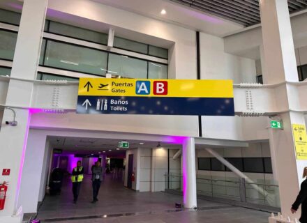
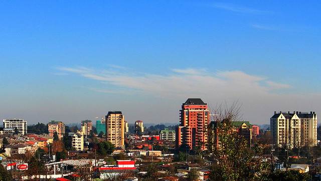
TEMUCO
It is located at 674 km. south of Santiago.
Temuco is the Capital of the La Araucanía Region. It is situated on the banks of Cautín River, and it is surrounded by Ñielol and Conún Huenu Hills. Also, this is an important administrative, commercial, university and cultural center.
It was founded on February 24, 1881, by Don Manuel Recabarren. A fort made of rushes and mud, and a pit to keep Mapuches at bay were the first buildings of the city. In the surrounding area, a group of people of diverse nationalities developed. The population of the city is 200,000 inhabitants and it is one of the most important and progressive cities of the country.
Some remarkable places to visit are: Araucanía Regional Museum, Ñielol Hill Natural Monument, Municipal Market, Handcrafting Production Center of Universidad Católica, Niri Vilcún Zoo, the Free Market, Municipal Cultural Center, Aníbal Pinto Plaza de Armas, Municipal Sport Complex and shopping centers.

VILLARRICA
It is located at 86 km. southwest of Temuco.
This is an administrative center that receives the tourists visiting the lacustrine area. It has interesting places to visit, which are an evidence of its historical and cultural development.
It is located at 764 km. south of Santiago. It has an approximate population of 36,000 inhabitants. After its foundation in 1552, which was commanded by Don Pedro de Valdivia, it was abandoned in 1554 and repopulated in 1559. In 1602, it was destroyed by the Mapuches, who dominated it until 1883. In that time, by means of an agreement held between Epulef Cacique (Mapuche chief) and Colonel Gregorio Urrutia, the area was peacefully taken over definitely by the Government. It was reconstructed and transformed into a city in 1897. On July 1916, the Community of Villarrica was created. It was named after the plentiful gold and silver deposits that existed in the area. It has important interesting places, such as: the Museum, La Ruca (Mapuche hut), the Pier, the Cathedral, Rodrigo de Bastidas Bridge, Villarica Historical Site, etc. Important social events are held in this city: Mapuche Cultural Exhibition, Villarrica Musical Festival, Interlagos Raid, and others.
PUCÓN
It is located at 110 km. southeast of Temuco.
This is an internationally distinctive tourist center. Pucón is a beach city situated on the banks of Villarrica Lake, which is surrounded by an exuberant and abundant native vegetation. National Parks (Villarrica) can be found near Pucón.
It offers several tourist services, such as an Hotel-Casino, cabins, camping areas and boarding houses.
Here you can practice rafting, Villarrica Volcano climbing, mountain bike excursions, and water sports (windsurf, laser sailing, speedboat racing, etc.). There is an international passage (Mamuil – Malal) that provide access to Junin City in the Andes, Argentina
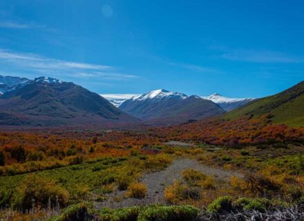
IX Region: Mountain range
VILLARRICA VOLCANO
It is located at 12 km. south of Pucón
Here you can find ski trails and facilities. You can get a magnificent view of Villarrica and Huilipilún Lakes.
It is situated in Villarrica National Park. It is 2,840 m. high. Its crater has a diameter of 400 m. The typical flora species are broom sedges, lengas and oak trees. The typical fauna species are pumas, foxes and hares. The climate is characterized by a high annual rainfall average and snow, which reaches 3 m. high in winter.
LONQUIMAY VOLCANO
It is located at 40 km. northeast of Curacautín.
This beautiful volcano is 2,865 m. above sea level. Here you can find a new winter center where ski can be practiced.
It is situated next to Tolhuaca Volcano, but it is younger. Height polar weather prevails.
The typical flora species of the Volcano are mosses and lichens stuck to volcanic rocks, and araucarias.
It has a singular shape which resembles a cone without its top. You can find ski trails, two surface cable lists of 200 m. and 600 m., and a refuge that offers cafeteria services and equipment hiring.
LLAIMA VOLCANO
It is located at 78 km. east of Temuco, specifically in Conguillío National Park.
In its slopes you can find Las Araucarias Ski Trails, situated at 1,800 m. above sea level.
There are two anchor-type cable lists.
The Volcano is well-known for the presence of araucaria forests, Chilean and Argentinean endemic conifer, which can reach a height of 50 m. with overlapping and evergreen branches
SIERRA NEVADA
It is located at 35 km. southeast of Curacautín.
In its heights, you can find araucarias, coigues, lengas and sections of hualles.
It is a chain of mountains of 2,554 m. above sea level. These chains are separated each other by deep ravine, where many rivers and streams flow, such as El Blanco, El Turbio and El Torrentoso.
Its typical fauna species are pumas, hares, rabbits and other minor species.
Most of its summits are covered with snow all the year round.
Access: Between December and March.
TUNNEL LAS RAÍCES
It is located at 26 km. southeast of Curacautín.
This is the longest tunnel of the country.
Its construction finished in 1938. In the first years, while the railway connection to Lonquimay was under construction, the tunnel was used to convey highway traffic. In 1958, it also conveyed railway traffic. From this moment, it was decided that Las Raíces would be a mixed traffic tunnel. The project was carried out in the 80 s.
Its measures are: 4,528 m. long, 30 m. high, and 4.70 m. wide.
ÑIELOL HILL
It is located in Temuco, 7 blocks of Plaza de Armas.
It has a superficies of 80, 65 hectares. Evergreen beech, oak tree, laurel, boldo, notro, hazel tree, cinnamon tree, lleuque, mañío, and tineo are its typical vegetation. Stork, turkey buzzard, traro, chimango, thrush, kestrel, chercan, fox, hare and rabbit are among its typical fauna. There are 5 hiking paths. The most distinctive attractions are Agua Santa, Puente de los Suspiros, Glorieta de los Enamorados, La Patagua, Huapi Lagoon and Los Patos. It has an environmental information center, viewpoints, a restaurant and picnic areas.
IX Region: Folklore and traditions
CHOLCHOL
This town is located at 21 km. northeast of Nueva Imperial City.
This is an old town situated on the banks of Nueva Imperial River. Cholchol was a passage way for Spanish conquerors. Northerly, you can reach Galvarino and Traiguén towns, and then the old conquest times road. Nowadays, it is a picturesque village where Mapuche culture and people are still living.
TEMUCO MUNICIPAL MARKET
It is located in the downtown city.
It was inaugurated in 1929. This is the principal and the traditional trade and exhibition center of the region, where handcrafting, specially Mapuche, can be found. Wooden works, hand-made woollen textiles, Mapuche silver and bronze ornaments and jewels; wickerwork articles, ceramics, and musical instruments are sold here. Typical food restaurants can also be found here.
ANGOL S BROTES DE CHILE FESTIVAL
Folkloric musical competition, whose objective is to spread and preserve our typical roots. It is held every first fortnight of January for three days.
TRADITIONS
Horse threshing in the remote areas of Cordillera of Nahuelbuta; Saint day celebrations, such as; San Juan, San Francisco and La Candelaria festivity.
LUMACO S REGIONAL CHAMPIONSHIP OF CHUECA
Lumaco is located at 60 km. southwest of Angol.
A “chueca” or “palín” (typical Mapuche sport competition) championship is held here. The championship is held every February, and teams from throughout the Region come here to participate.
IX Region: Gastronomy
The regional gastronomy is characterized by Mapuche typical dishes, such as “ñachi”, which is lamb blood seasoned with lemon juice, salt, “pebre” (Chilean hot sauce prepared with tomatoes, onions, chili peppers, and coriander) and chili peppers. Other typical dishes are: Tenca, which is a kind of pre-boiled zucchini filled with stirred eggs and potatoes that is then baked; pork or turkey “cazuela” (a soup prepared with potatoes, pumpkins, rice, and meat); lamb, pork, rabbit or goose barbecue. Corn, barley and apple are the base of tasty and essential beverages to accompany typical food.
IX Region: Islands and archipielagoes
HUAPI ISLAND
This island is located nearby Budi Lake
Huapi is inhabited mainly by Mapuches, who still keep traditions and culture alive.
You can access this place by boat, ferry or barge, which travel along Budi Lake in approximately one hour.
LAKES AND LAGOONS
CALAFQUÉN LAGOON (northern bank)
It is located at 27 km. south of Villarrica.
It has an approximate superficies of 180 km2. It is situated 2,000 m. above sea level. It is characterized for being long and narrow. Lican Ray Beach Town is situated on the north bank, where cabins and summer services are offered. Lican Ray organizes Chile s biggest barbecue (2 km. long), which congregates 500 people.
Swimming, fishing and water sports can be practiced in Calafquén Lake. This lake also belongs to Los Lagos Region, as well as Coñaripe and Calafquén Beach Towns.
CABURGUA LAGOON
It is located at 23 km. northeast of Pucón.
This is a natural beautiful lake. The landscape is completed by Villarrica Volcano, woods and Ojos del Caburgua.
Caburgua Lake is mainly long-shaped, and it is surrounded by woodland hills and volcanoes, such as Villarrica Volcano, which constitute the lake s origin.
One of its main attractions is Ojos del Caburgua, which is an exuberant group of natural pools surrounded by forests, where groundwater of Caburgua and other streams flows. Its waters are warm and transparent. There are long and rocky beaches. The longest one is Blanca Beach, which reaches 5 km. long. Negra Beach reaches 500 m. long.
VILLARRICA LAKE
It is located at 86 km. southeast of Temuco.
This glacial origin lake has an approximate superficies of 170 km2, and it is situated at 230 m. above sea level.
It has a rectangular shape and it is very deep. It is surrounded by mountains and country fields. Villarrica And Pucón are situated on its banks, where vast beaches can be found, such as; Pucará, Linda, Kurilaquén and John Kennedy. Its waters are crystalline, and swimming and water sports can be practiced here. It is emptied by Pucón, Menetué and Quilhue Rivers, and several streams
DE ICALMA LAGOON
It is located at 52 km. southeast of Lonquimay.
Its waters are transparent and it is surrounded by native woods. Mapuche reservations can be found in this area.
It is situated at 1,350 m. above sea level, specifically at 5 km. from the Argentinean frontier. It has a superficies of 890 hectares, and originates Biobío River.
Camping areas and boat hiring services can be found on its banks. Swimming and water sports can be practiced. There are several greyish fine sand beaches.
It is surrounded by araucaria trees and ñirres, there are also scrublands. Its waters are cold and transparent. Some birds found in this lake are swans, jergon ducks, coots and others.
CAPTRÉN LAGOON
It is located northwest of Conguillío National Park.
Its is well-known for its transparent, cold waters, which allow to see lots of submerged trees. Trout fishing is practiced here.
BUDI LAKE
It is located at 5 km. south of Puerto Saavedra. This brackish lake has a superficies of 70 km2 . Its bank is wave-shaped and presents water meadows, swamps and several islands. The excellent natural conditions allow several kind of birds to nest here (black necked swans). Its waters are warm and shallow. The banks and islands of Budi Lake are inhabited by Mapuches who live on agriculture and fishing.
IX Region: Historical sites and monuments
SAN CARLOS DE PURÉN FORT
It was declared a national Monument in 1975. It is located in a 50 m. high headland, from where you can see Purén Valley. It dates from 1869. Mapuche caciques (chiefs) and the commander of the pacification troops agreed the construction the fort. It has a approximate superficies of 2,500 km2. It is surrounded by a palisade, and it has a footbridge and two surveillance fortified towers in each corner. This is the only fort that has been rebuilt in this region. A Mapuche archaeological exhibition can be found here.
ESCULTURAS DE MÁRMOL BLANCO (white marble sculptures) AND THE ESPEJO DE AGUA OF ANGOL S PLAZA DE ARMAS
It was declared a National Monument in 1986. Angol s Plaza de Armas is considered one of the most beautiful squares of Chile. There is a fountain in the central part of the square. In the corners of the fountain you can find 4 sculptures, which represent the four continents known at that time (1862): America, Europe, Asia and Africa. They were sculpted by Virginio Arias, and they are surrounded by trees like magnolio, cypresses and cedars.
DEL MALLECO VIADUCT
It was declared a National Monument in 1990. It is located in the 567th km. of Panamericana Sur Highway, at 1 km. of Collipulli.
It was built over the deep water ravine of Malleco River. Del Malleco Viaduct is one of the biggest metallic engineering works of Chile.
It is 407.5 m. long and 97.6 m. high, between the rail and the water level. It has 5 extremely high towers, in whose corners you can see cylindrical columns crowned by beams that support the railway. It was designed by Victorino Lastarria and prefabricated in France. Its assembly took 3 years. It was inaugurated by the President J.M. Balmaceda on October 26, 1890.
IX Region: Snow
VILLARRICA SKI CENTER
It is located at the foots of Villarrica Volcano, at 19 km. south of Pucón. It is specifically situated on the hillsides of Villarrica Park. It is located 1,500 m. above sea level. It has 6 surface cable lists, 3 double-chaired cable lists, cafeteria, ski equipment hiring services and ski classes.
LAS ARAUCARIAS SKI CENTER
It is located at 78 km. east of Temuco and 1,800 m. above sea level, at the foots of Llaima Volcano. It is specifically situated in Conguillío National Park, which is well-known for its araucaria woods. It has 2 surface cable lists, a cafeteria, ski equipment hiring services and ski classes.
IX Region: National parks
CONGUILLÍO NATIONAL PARK
It is located at 25 km. north of Melipeuco. Its distinctive attractions are Llaima Volcano, where you can find a ski center, and the exuberant Cordillera landscape characterized by abundant vegetation, lakes and lagoons. There are camping areas. It belongs to Melipeuco and Vilcún Communities. You can get access to this place by:
1. – Cajón Road to Llaima Volcano (66 km.),
2. – Curacautín Road to Conguillío (42 km.),
3. – Melipeuco Road to Conguillío (25 km.).
It has a superficies of 60,832 hectares divided into two areas: a) Los Paraguas Area, which provides access by Cajón – Vilcún – Cherquenco to Llaima Volcano and to its ski center. b) Conguillío Area, which provides access by Curacautín or by Melipeuco to Conguillío Lake.
The climate is influenced by the mountain relief (high annual rainfall average). Due to the low temperatures present in winter, snow reaches 2 and 3 m. in some areas.
In summer, the temperature reaches an average of 15º C. The typical flora species of this Park are: oak trees, evergreen beeches, and vast araucaria forests, etc. Pumas, culpeo foxes, woodpeckers and psalmodies species are the typical fauna species of this zone.
It has a visitors center, and expeditions can be made through different paths.
NAHUELBUTA NATIONAL PARK
It is located at 35 km. west of Angol.
Araucaria is the predominant species of this place. This park has an information center, a small flora and fauna museum, and camping and picnic areas.
It was created on January 4, 1939. It is situated at the top Cordillera of the Coast, at about 950 and 1,565 m. above sea level approx. It has a superficies of 6,832 hectares. There is a road system of 30 km. for light weighted cars, and 15 km. of paths and viewpoints. Vegetation: araucaria, coigue, evergreen beech and ñirre woodlands.
Fauna: Puma, monito del monte, Chiloé fox, black woodpecker and others. It is important to mention Las Totoras, Las Turberas, La Piedra del Aguila, and other lagoons.
Admission is charged.
VILLARRICA NATIONAL PARK
It is located at 12 km. south of Pucón.
Some important places found here are Villarica Volcano and the Villarrica Ski Center. This Cordillera environment has an abundant and diverse flora and fauna.
This important natural area is under governmental protection. It has 65,400 hectares. Its relief is rugged and irregular, which is a consequence of the volcanic activity of the following volcanoes: Lanín (3,870 m.), Villarrica (2,840 m.) and Quetrupillán (2,382 m.). It has tablelands covered by woods that can be found until 1,500 m. high, and an abounding and diverse flora and fauna. Here you can find camping and picnic areas, hiking paths, and an information center.
Villarrica Volcano is one of the main attractions, because it has a ski center, a cafeteria. The Park reaches the communities of Villarrica, Pucón, Curarrehue and Panguipulli. It also includes Blanco, Azul, Abutardas, and Quillelhue Volcanoes, and Peinetas, Porúe, and Los Venados Hills.
TOLHUACA NATIONAL PARK
It is located at 45 km. north of Curacautín.
Its main attractions are its natural and exuberant landscape, and its flora and fauna. It has 5 paths for making expeditions, and camping and picnic areas.
It has a superficies of 6,378 hectares, and it comprises the communities of Curacautín and Collipulli. On its western limit, it reaches 700 m. above sea level, and on its eastern limit it reaches 1,821 m. above sea level. The whether is temperate, cold and humid, characterized by the absence of arid periods.
Flora: oak trees, coigues and araucarias.
Fauna: pumas, coypus, foxes, chillas (small foxes) and guiñas.
HUERQUEHUE NATIONAL PARK
It is located at 35 km. northeast of Pucón.
It is characterized by its rugged relief and for being situated in one of the more beautiful place of the Region. It has a superficies of 12,500 hectares and it is situated at 2,000 m. above sea level.
The climate is temperate-warm, with the presence of less than 4 dry months and polar temperatures due to the height. Rainy season lasts from May to September. Its annual rainfall average is 2,045 mm.
Condors, culpeo foxes, bufo frogs, Darwin frogs, chucaos, pumas, coypus, and guiñas are the typical fauna species found here. Araucaria, coigue, lenga, mañio, and tepas are the typical flora species found in the Park.
20 lagoons have been formed by its rugged relief, which are emptied by strings, rivers and streams that flow from the top of the mountains.
You can only visit this Park during summer. The observation of forests and Caburgua and Tinquilco Lakes is highly recommended, as well as sightseeing Villarrica, Quetrupillán, Lanín and Llaima Volcanoes. Here you can practice sport fishing, swimming, boat trips, mountain climbing and photographing.
You can also find camping and picnic areas on the banks of Tinquilco Lake.
There is an Environmental Information center.
MALALCAHUELLO NATIONAL RESERVATION
It is located at 38 km. east of Curacautín.
It has a superficies of 31,260 hectares. Lonquimay Volcano with its winter center constitute the main attractions.
It belongs to the communities of Lonquimay and Curacautín. Coigüe, evergreen beeches and araucarias are the main flora species found here. The typical fauna species are culpeo foxes, skunks, pudú and pumas.
IX Region: Beaches and rivers
MAULE BEACH
It is located at 2 km. south of Puerto Saavedra.
This is the most qualified beach town of the regional coast. It is 15 km. long, and it is ran through by Imperial River Outlet. The average temperature is 11.3º C and rainfall reaches 1,186 mm. It is a blue, dark and soft sand beach which is apt for swimming. The wave motion is strong, but it is not hazardous.
RIVERS AND WATERFALLSCAUTÍN RIVER
It springs out in the southern foothills of Lonquimay Volcano, at 1,850 m. above sea level. It is 150 km. long until it empties into Imperial River. From its basin (Curacautín) to Muco River confluence (north of Pillalelbún), Cautin presents a drop of 600 m., and a long curve.
When it runs through Temuco, it reaches an average height of 80 m., and a height of 55 m. from Nueva imperial to its outlet. It is not apt for navigation from the confluence with Chol–Chol River.
TOLTÉN RIVER
It springs out in Villarica Lake and empties 145 km. south of Toltén. Sport fishing, photographing, and excursion hiking can be practiced here. In its lower course, it is apt for navigation, thus fishermen can go downstream from Pitrufquén.
DONGUIL WATERFALL
It is located at 5 km. south of Gorbea.
It is approximately 6 m. high. It is surrounded by abundant vegetation, mainly ferns, eucalyptus, hualles, oaks, and others.
Swimming can be practiced in an area called El Santo, along a 150 m. zone. There is a natural swimming pool surrounded by pines, eucalyptus, willow trees, coigues, chilcos, etc. The color of the waters is deep green.
EL INDIO WATERFALL
It is located at 15 km. east of Curacautín.
It is 60 m. high. During winter, a new fall is added to this waterfall due to the rainfalls, and a series of small waterfalls can be found on the southern banks of the River.
This waterfall originates in the confluence of Cautín River.
EL LEÓN WATERFALL
It is located at 30 km. southeast of Pucón.
It is approx. 90 m. and has two consecutive falls. In the surrounding landscape you can find centenary forests and abundant vegetation. Flora: mainly oak trees, coigues, and some ulmos, evergreen beeches, and cypresses, and also some other minor species like Chilean bell flowers.
Fauna: Hares, foxes, thrushes, and others.
TRANCURA RAPIDS
It is located at 15 km. northeast of Pucón.
Here you can practice rafting, a sport activity well-known throughout the world. The rapids are 14 km. long.
Trancura River springs out in Curarrehue, near Pucón. The starting point is situated at 15 km. of Pucón.
Downstream rafting takes approximately half an hour, crossing 8 rapids. Some of them have 3 and 4 levels (rapids level rate from 1 to 6). The abundant vegetation that covers the river banks can be seen from the River. Quelhue Hill can be sighted on the right side of the river.
MALLECO WATERFALL
It is located at 45 km. north of Curacautín.
It is 50 m. high; its abundant flow falls into a semicircle formed over volcanic material that originates the drop of Malleco River.
MALLECO RIVER.
It is located at 45 km. north of Curacautín.
Malleco River basin springs out on the western side of Tolhuaca National Park rivers, generating more humid vegetation on its banks. Some of these species are: broom sedge, ñirre, coigue and oak tree.
LA PRINCESA WATERFALL
It is located at 22 km. east of Curacautín, specifically, in Malalcahuello – Nalcas National Reservation.
It is 50 m. high; it is situated the midst of an almost unexplored place. There is a path that provide access to the top of the cascade.
IMPERIAL RIVER
It is located at 35 km. west of Temuco.
This river is emptied by Cautín, Chol-Chol and Quepe Rivers. The total extension reaches 220 km. Its waters are transparent.
Flora: notros, hawthorns, and aromos.
Fauna: wild ducks and psalmody species.
Draught vessels can navigate the Imperial River from Carahue area. Swimming is allowed in some sections, specially in Quillén Beach Town (in front of Carahue), Colgante Bridge and Nehuentué and Moncul Beaches.
IX Region: Thermal baths
PANQUI HOT SPRINGS SPA
They are located at 18 km. southwest of Curarrehue.
Warm water springs out at both sides of Panquí River, filling out several pools. It also has a mud pool, which is recommended for skin, stress, rheumatism, and arthritis.
They are situated in Panqui area, at Villarrica National Reservation, specifically on the banks of Panqui River (1,000 m. above sea level). The temperature of the waters fluctuate between 36º and 42º C. The mud springs out at 36º C.
SAN LUIS HOT SPRING SPA
It is located at 31 km., in Pucón Curarrehue Road.
It has 12 springs where the temperature fluctuates between 25º y 45º C. The chemicals characteristics of the waters are: sulphate, sodium, alkaline, treated with chloride, and specially sodium and sulphate.
Ferns, quilas, maquíes, wild fuchsias and maticos can be found on the banks of the thermal pools.
It has two pools and many bathtubs, cafeteria, restaurants, cabins, and picnic and camping areas.
It is open all year round.
TOLHUACA HOT SPRING SPA
It is located at 33 km. north of Curacautín.
These waters are recommended to treat respiratory illnesses, articular and muscular rheumatism, acute gout, chronic inflammations, pulmonary sclerosis and dermatitis.
They are situated at 1,150 m. above sea level. The waters flow at a temperature of 96º C. They are open from November to April. Hiking excursions, climbing, and fauna and flora observation can be practiced here. Hotel facilities can be found here. Transport service is available in Curacautín.
Among its therapeutic characteristic, you can find thermal water baths (bathtubs), mineral water, mud cataplasmas, and inhalations.
HUIFE HOT SPRINGS SPA
It is located at 33 km. northeast of Pucón
These hot natural waters are recommended for stress, nervous fatigue, arthritis, rheumatism, and skin illnesses. It is splendidly located nearby Pucón, which is one of the most attractive beach towns of the Region.
They are situated at 450 m. above sea level, on the banks of Liucura River, where you can find abundant vegetation.
The temperature of the waters is 38º C. Expeditions, flora and fauna observation, hiking, swimming and various recreational activities can be practiced here. It has facilities such as: thermal bathtubs, swimming pools and hydromassage systems. Transportation is found in Pucón. The place is open all year round.
MANZANAR HOT SPRINGS SPA
It is located at 18 km. east of Curacautín.
These mineral thermal waters are recommended for treating bronchial and rheumatic affections, curing of poisoning, skin and spinal column treatments. They are situated at 680 m. above sea level, in the midst of an exuberant vegetation landscape. Thermal bathtubs can be found here. Expeditions can be made here, also you can practice recreational activities in the thermal center. Transportation to this place departs from Curacautín. The place is open all the year round.
Adventure tourism
CORDILLERA OF NAHUELBUTA
Location and access: 40 km. southwest of Angol, by an unpaved road.
It is situated in Nahuelbuta National Park, where araucaria tree is the most important flora species. This place has paths where you can practice trekking, off road, observation, camping and mountain biking.
CONGUILLÍO NATIONAL PARK
Location and access: 42 km. southeast of Curacautín, specifically at 25 km. of Melipeuco and 81 km. of Temuco by Cajón – Vilcún – Cherquenco Route.
It has a superficies of 60,832 hectares and it is situated at 3,125 m. above sea level. It comprises Llaima and Sierra Nevada Volcanoes where you can find their two principal valleys: Captren River Valley, towards Curacautín; and Quetralelfú River Valley, towards Melipeuco. The landscape is almost unexplored, where you can find 1,200 year-old araucaria woods and oak trees, coigues and cypresses located nearby waterfalls. Neither pets nor motor boats are allowed in this park or in its lagoons.
TOLHUACA NATIONAL PARK
Location and access: 35 km. north of Curacautín.
You can get access to this National Park by crossing valleys in which you can find woods areas, and then narrow ravines covered by oak trees, coigues, and araucarias. It has a superficies of 6,374 hectares, both of them are 12 km. long and go through araucaria, tepa, and laurel forests. Another path, which is 8 km. long, follows the basin of Malleco River towards Malleco Waterfall, La Culebra Waterfall (49 m.) and Malleco Lagoon. Off road, hiking and trekking can be practiced here.
MALALCAHUELLO AND NALCAS NATIONAL RESERVATIONS
Location and access: 55 km. east of Curacautín.
They have a combined superficies of 31,305 hectares, where abundant flora and fauna can be found.
Ski Center: It is located at the foothills of Lonquimay Volcano. The trail have no stones, which makes it ideal for practicing randoneé ski and speed ski. A road ideal for 4×4 vehicles, which provides access to Contraco, can be found here. This road goes along Biobío River towards Lonquimay Volcano, whose crater (Navidad) covered with lava a section of the Valley of Nalcar River, during an eruptive activity.
ICALMA LAGOON.
Location and access: 34 km. east of Melipeuco, by an unpaved road.
This is a small lagoon surrounded by woods and rugged slopes. It has a superficies of 890 hectares and it is situated at 1,350 m. above sea level. It has several grey and fine sand beaches.
It is surrounded by araucaria and ñirre forests and descends through deep glacial valleys. Its waters are cold and transparent. The road goes along the southern banks of Trancura River, where camping, mountain climbing, hiking and trekking can be practiced.
Fauna: swans, jergon ducks, coots, etc.
GALLETUÉ LAGOON
Location and access: 53 km. northeast of Melipeuco, by an unpaved road.
This lagoon constitutes an attractive landscape. It is surrounded by centenary araucaria, coigue, lenga and ñirre forests. Its waters are transparent and crystalline.
Fauna: abutarda, royal ducks, jergon ducks, coots, ringdoves and eagles.
TRANCURA RIVER
Location and access: rafting site is located at 14 km. east of Pucón.
Abundant native vegetation can be found in its slopes, such as: mañios, ulmo, laurels and other species. On the right side of the river, we can find Quelhue Hill, which is the place where this river empties. The river is known by its rafting levels 3 and 4. Downstream rafting from the highest area of the River, Alto Trancura, takes three hours approximately. You cross 14 km. going over eight rapids. The rafting season goes from October to March.
Trancura meets with other two streams: Liucura River and with its affluent (Turbio), which flows from Villarrica Volcano.
In the southern section, these rivers are ideal for practicing canoeing and rapids descent. This area has a diversity of lakes, rivers, woodlands, glaciers, and mountains.
VILLARRICA VOLCANO
Location and access: 25 km. south of Pucón.
Boiling lava can be sighted in its crater. Near the Volcano, there is a hotel that has seven hot springs spas, being the most visited: El Huife, Palguín, Pangui, San Luis and Menetué. Enormous thermal swimming pools can be found here
CABURGUA LAKE
Location and access: 23 km. northeast of Pucón, and it is situated at 700 m. above sea level. Caburgua Lake is mainly long-shaped, and it is surrounded by woodland hills and volcanoes, such as Villarrica Volcano, which constitute the lake s origin. One of its main attractions is Ojos del Caburgua, which is an exuberant group of natural pools surrounded by forests, where groundwater of Caburgua and other streams flows. On the banks of this lake you can practice trekking, hiking, climbing, camping and off road.