VIII Region: Main cities
CONCEPCIÓN
The regional capital and is located at 86 km. east of Bulnes. A University and cultural center that has a maritime climate and intense industrial, commercial and financial activities.
In the Plaza de Armas of Concepción and on the 10th of January of 1818, the Independence of Chile was claimed. Afterwards, the plaza was renamed as the Plaza de la Indepenecia.
The city was founded by Don Pedro de Valdivia in 1550. Now, it is a modern city with important cultural centers and an active university life. It is united with the rest of the country by plane, train and highway.
At the surroundings, there are many points of interest such as: the Biobío river outlet, the University quarter, the Municipal Market, the Mural of the central Station, the Cathedral, the Ecuador Park, the Art House ( Pinacoteca), the Museum of Concepción, the big and small lakes of San Pedro, San Pedro Chapel, Llacilén Municipal resort, the Biobío river, the Escuadrón Beaches, the Amarillo and Caracol hills, the Juan Pablo II Bridge, the Tribunals Palace, the Plaza de la Independecia, the History Gallery, the rests of the stone walls of the Merced Convent and the Mausoleum of general Don José María de la Cruz.
CHILLÁN
A modern city located kilometer 402 of the Panamerican highway. It is city of regular layout, broad streets with trees and intense commercial and agricultural activities. It is one of the twelve city in Chile that were founded in the XVI century. Its Mapuche name means ” the seat of the sun”. San Bartolomé de Chillán was founded in 1580 by Marshall Martin Ruiz de Gamboa.
The Central valley is an eminently agricultural zone and birth place of famous personalities of the national history such as: Bernardo O Higgins, Arturo Prat, Claudio Arrau and Ramón Vinay.
The most important attractions are : the Bernardo O’Higgins Monumental Park, the Cathedral Church, the Siqueiros Murals, the Convent of los Padres Carmelitas, the Hospital of San Juan de Dios de Chillán ( a declared National Monument in 1972), the Franciscan Museum and the Arturo Prat Naval Museum. In the urban sector, you also fin the Market and Fair where there is a big and varied collection of artesian articles.
TALCAHUANO
It is the main military, industrial and fishing port of the south zone of the country. It is located at 16 km. north-east of Concepción.
It has a population of 220.000. it is an important national industrial center that has siderurgia, petrochemical complex, astilleros, metal and mechanical industry and sea products elaboration companies.
The most relevant attractions of Talcahuano and its surroundings are: the Huáscar monitor, Ramuntcho and Rocoto beaches, the Biobío river outlet, the San Pedro Fiesta, the fish Market, the Hualpén Museum and Park, the Ventana seaside road, la siderúrgica Huachipato, the Los Perales hill, the Quiriquina hill, the Martínez de Rosas Street, the La Gloria hill, the Nuevo hill, the O Higgins General Quarters and the Hualpén peninsula natural Sanctuary.

LOS ANGELES
The regional capital and It is located at kilometer 510 of the Panamerican South highway and at 110 km. south of Chillán. It was founded on the 26th of may 1739 by Don José Antonio Manso de Velasco. Today, it is an imporatnt city due to its agro-industries and especially referring to the industry of paper because of the cellulose industries located in the zone. Its buildings have a audacious architecture, numerous commercial galleries and important universities of the country. Its population is approximately 142.000. The most important attractions are: the Capuchina and los Padres Alemanes Churches, the Los Angeles Fair, the History Museum, the park and Chapel of the San Sebastián Hospital ( declared a national Monument in 1989). At the surrounding areas, we would like to mention places such as: the Villages of Yumbel and Cabrero, the Laja falls, the Las Canteras Estate and the Huaqui and Laja rivers.
VIII Region: Mountain range, mountains and hills
ANTUCO
It is a pre-Andes zone located at 85 km. east of Los Angeles. Its main attraction is the Laja Lagoon National Park.
The tourism activities gets busy during the winter season when the ski trails open and during the summer tourists visit the National Park, created in 1958, which has an area of 12.000 hectares. The lagoon has an abundance of trout and salmon fish.
Among its other attractions are La Novia and El Salto del Trubunleo water cascades that has waters falling from such a considerable height that it form light mist in the area. pours water
COIHUECO
A locality situated at 26 km. north-east of Chillán. It is a pre-Andes community with native woods and plantations of different introduced species. It is known for its big production of sugar beet. The most relevant tourist attractions are the reservoirs, festivals, handmade artesian wooden articles and woven textiles.
VIII Region: Folklore
COBQUECURA
Extended beaches that are situated at 105 km. north-west of Chillán. It offers more than 50 km. of beaches where there are gatherings of rocks with curious formations such as ” La Lobería” which serves as a refuge for sea wolves.
The artesian articles made of clay, agave, wicker and wool textiles are some of the characteristics of this village.
At a few blocks is situated the “Piedra de la Loberia”, and towards the south of the village you could visit the Mure, Alta Piedra, Rinconada and Cueva de Huilquicura Beaches. You can also find the Igelsia de Piedra and Cobquecura.
NINHUE
A painteresque village located at 46 km. north-west of Chillán. In this place, you would encounter the San Agustin de Puñual Estate, a place where Arturo Prat Chacón, the hero of the Chilean navy, was born. The village is distinguished by its Ninhue Chapel and some of the artesian articles of which we would like to mention the Chupalla de Paja trenzada or “Cuelga”.
QUINCHAMALI
A small village located at 30 km. south-west of Chillán. It is considered one of the most important pottery centers of the country. It offers a variety of objects made of loza negra used for decoration or daily use and with drawing with white paint.
Quinchamalí; is an indigenous name of a herb abundant in the zone.
The artesian articles have give the village a national an international reputation. Its clay articles are already found in the Louvre de Paris Museum, the New York Contemporary Art Museum and the national Museum of Moscow among other.
The “Guitarrera” is the piece that most represents the place and it is a symbol of the artisan work of the country.
QUIRIHUE
A locality situated at 59 km. north-west of Chillán. It was founded in January 1749 with the name of Villa San Antonio Abad de Quirihue. This village is distinguished by its artisan handmade hats and Chupallas.
Gastronomy
The gastronomy of this region is mainly based in fish and seafood of which we distinguish the Mariscal which consists of a mixture of a variety of seafood such as, edible shellfish, ulte, pink clam, large mussels, navajuelas and others. The Pebre which is used as on the side ingredients which consist of onions, cilantro, chili, lemon, salt and oil. The Plumai or Curanto which consists of pork chops skin, lamb ribs, chicken, spicy pork sausage, fish and seafood all cooked with potatoes.
As a digestive, you could taste the Enmurtillado which consists of a mixer of liquor with myrtle and fruit fragrance of the region.
VIII Region: Islands and archipelagoes
ISLANDS AND ARCHIPELAGOES In the coastal areas of this region, we can distinguish some islands near to the continent. Due to their proximity to the coasts made them frequently visited by the Mapuche people even before the arrival of the Spaniards.
MOCHA ISLAND
It has an ovoid form and superficies of 48 km2. It is located in front of Tubul. Its geological constitution has a central platform that ends in a 300 m. high cone-shaped land. From the hills, we can see many fountains pouring their waters irrigating the slops of the hills which became covered with varied , native and exuberant vegetation. In the coastal areas, there are many rock formations that provide shelter for the marine fauna.
The island can be reached by taking boats from Tirúa that leave three times a week in a three-hour voyage or from Concepción by plane.
SANTA MARÍA ISLAND
It is located in the Arauco Gulf and called the Saint Island. It is 11.5 km long and has superficies of 32 km2. It is scarped it all its perimeters with the exception of the side that faces the Arauco Gulf.
The vegetation has almost disappeared because of the fires yet it is still visited by cormorant, partridge, pollitos de mar and albatross.
QUIRIQUINA ISLAND
It is the smallest of the three islands and is situated in the north in the Concepción Bay. It has one third of the size of the Santa Maria and is located 60 km in a straight line towards the north and in front of Tomé in the Concepción bay.
Its name is Mapuche and means the strip of the Fox. Its center has an altitude of 120 m. and still has cinnamon, oak, myrtle and boldo trees. It is a rive surrounded by planes for grazing for animals. It has many lignite an charcoal which at a certain time was used as fuel when Garcia Hurtado de Mendoza and his people stayed their for three months in 1557.
In the coastal areas of this region, we can distinguish some islands near to the continent. Due to their proximity to the coasts made them frequently visited by the Mapuche people even before the arrival of the Spaniards.
VIII Region: Lakes and lagoons
THE LAJA LAGOON
It is located at the interior of the “Laguna de la Laja” National Park at 100 km. east of Los Angeles. It is situated at the feet of the Antuco volcano at a 1700 m. above sea level altitude. The lagoon is 125 km2 of superficies and its waters are appropriate for salmon fishing. In this area, there is a predominance of birds and mammals such as vischachas, puma and fox. Among the activities that you could practice if fishing, skiing, climbing, excursion, and panoramic observation, and boat rides.
THE AVENDAÑO LAGOON
It is a lagoon that is situated at 28 km. west of Bulnes and at 67 km. of Concepción. Its calm waters is perfect for waster sports and fishing. The surrounding landscape is constituted by small and green hills and a privileged microclimate.
The Avendaño lagoon is apt for water skiing, velersimo, swimming and other water sports, fishing and fauna and flora observation. There also camping areas, shacks and resturants. There is also another tourist complex at the banks of the Coyanco river. The main land elevation is constituted by the Cayumanqui hill that has native species and excursion places.
The “Carnaval de Quillón” is celebrated in the month of February. In the bridge sector that unites the Bulnes and Quillón communities, there is the “Paso el Roble”, a name that was given to it after a battle in which bernardo O’Higgins participated in 1813.
THE SAN PEDRO LAGOON
The small lagoon is situated at 4 km. south-west of Concepción and has superficies of 0.72 km2. The big lagoon, 1 km. further to the south, has superficies of 1.43 km2.
The most important attractions in the small lagoon are the municipal resorts, Llacolén, Ingenieria CAP, Victoria (Alemán) and Militar among others that permit the practice of water sports and recreational activities.
In the big lagoon, it is possible to practice velerisom and fishing.
CONTULMO
It is a locality that is located at 172 km. south of Concepción, beside the Lanalhue and Lleu-lleu lakes that constitute its main touristic attraction which provides for a increasing services for tourists such as shacks and camping.
It was born in the 19th century with the arrival of the German settlers in 1884. Its main economical activity is concentrated in the forestall and touristic one. The Lanalhue and the Lle-lleu lakes are the main attractions of the area. There is also the Santa Elena park which is located at 6 km. coming through the road to Purén where the Contulmo Forestall reservation is located.
THE PANGUE RESERVOIR
An artificial lake located at 55 km. south of Santa Barbara and at 2 km. of the Ralco village. It has superficies of more than 500 hectares and 14 km. long and reaches 1 km. in its narrowest place. As an artificial lake, it is used for sailing, boat promenades, sport fishing and has a beautiful landscape. At present, there is the “Faro del Biobío” complex which is a gathering of shacks and hostels and offers boat and horse rentals. In the Ralco village, there are three hostels which complements the offer of the complex.
THE EL BARCO LAGOON
It is located at 120 km. south-east of Santa Barbara between the Callaqui and Copahue volcanoes. In the middle of the lagoon, there is an island with the shape of a boat and which makes it an ideal place for the sport fishing activity. It offers a panoramic view , a place to be in harmony with nature and a quite and solitary refuge.
THE MULA LAGOON
It is located in the Ralco National Reservation at the feet of the Callaqui volcano. It is surrounded by Araucaria trees and abundant brushwood. It offers great panoramic beauty.
THE LANALHUE LAKE
It is located at 145 km. form Concepción just beside the Lleulleu lake which are the unique lakes located at the coastal cordilleras. It has arm waters and its surroundings are formed by Pine tree woods. It is located at an altitude of 8 m. above sea level and has superficies of 38 km2. Its Riviera form a peninsula, a bay and numerous beaches with fine sand. The water is transparent and has mild waves. Its surroundings has abundant native vegetation. The tourist installations are located in the west side of the lake in Cañet or Contulmo. The Lleulleu lake is nearby.
THE LLEULLEU LAKE
A lake that is situated at 12 m. above sea level and at 14 km. south-west of Contulmo. It possesses superficies of 40.4 km2. Among the most important attractions of the place are the Choque, Lolcura and Huillinco ports sector and the origin of the lleu-lleu river. It is possible to practice fishing, boat ride and water sports.
VIII Region: Historical places and monuments
MONITOR HUÁSCAR
In Talcahuanao, a commercial and industrial port, the Monitor Huáscar (1879) is conserved and converted in a Heroic Sanctuary.
THE CONCEPCIÓN PLAZA DE LA INDEPENDENCIA
It is a historical place where the General Bernardo O’Higgins proclaimed the Independence of Chile on the 1st of January 1818.
THE PRAT BIRTHPLACE SANCTUARY
The San Agustin Estate, located in the Ninhue Village at 46 km north-west of Chillán, is the birthplace of Don Arturo Prat Chacón. This site is a sanctuary and museum where objects and a portrait of the life of the hero of the Naval Combat of Iquique are exhibited.
The large house of typical countryside construction of the XVIII was declared a National Monument in 1968. The sanctuary is 8 hectares. The house has an interior portico, rooms with furniture of the era, a wing dedicated for the exhibition of the life of the hero and his ancestors and a wing for the Holocaust. In this sector, personal objects of the hero and parts of the Esmeralda are kept. There is an oratorio with a wooden cross made of boards of the Esmeralda and also a regional museum with samples of agricultural objects dating to 1848.
Ninhue is an important historical artisan community and an agriculture sustaining the community. However, it is only dignified to mention that it has a quantity of wineries that produce delicious must.
Typical Artesian: made of wheat straw used to manufacture Chupallas ( Traditional hat), bags, rush mat, etc..
THE LAS CANTERAS ESTATE
It is located at 30 km. east of Los Angeles. This place belonged to Don Bernardo O’Higgins. In the sector, there are chestnut trees planted by the Liberator when the agricultural activities of the zone were developing.
THE LA PLANCHADA FORTRESS
A Spanish fortress located at 12 km. east of Concepción in the Penco community. A testimony of the history of Chile which was constructed for the defense against the struggle against the Araucano people. It was founded in 1687. At present, it is reduced to only three canons. It is located at 50 m. from the Penco Train Station. Penco is a community distinguished by its forestall, fishing and port activities. It is also known for the ceramics industry.
THE SANTA JUANA DE GUADALCAZAR FORTRESS
A Spanish fortress founded on the 8th of March 1626 by Luis Fernández de Códroba and Arce and is a declared National Monument. It is located at 52 k. South of Concepción.
At present, it only has the walls and the access gate. Form it you can observe the Biobío river and part of the city of Santa Juana, a community that is adjacent with the communities of Nacimiento, Coronel, Curanilahue, Lota and Arauco. Their main activities are agricultural and forestall.
LOTA
It is an old mining village located at 9 km. south of Coronel. It is a village the depends on the exploitation of Carbon which was started in 1852 by don Matías Cousiño.
It was founded in 1662 by t he Spanish Governor Abgel de Peredo and on the 5th of january 1875, Lota was declared as a city. In 1852, Don Matías Cousiño purchases the lands where later he would establish the carbon industry.
The most distinguished attractions are the Isidora Goyenechea de Cousiño park, now known as Lota Park, the fortress of Lota which is located in the community and was declared a National Monument in 1926 in addition to the Colcura fortress which was declared a National Monument in 1977.
Lota is divided in two sectors: Low and High. Low Lota is located between the hills of the valley near to the sea where the public service offices and the commerce are located. In high Lota, there are the installations of the mine and the typical houses of a mining camp.
CAÑETE
An old city located at 8 km. north of the lanlhue lake. It was founded in 1552 by Don Pedro de Valdivia: It is also the death place of the Conqueror and the Toqui Caupolicán. I addition to its historical character, it constitutes a mandatory passage to access the Nahelbuta National Park and the lanlhue lake.
It has a population of 30.000 all dedicated to the exploitation of the forest and agricultural production. Its touristic attraction are : the Tucapel fortress, declared National Monument in 1963 and the “Juan Antonio Ríos” Araucano Museum, which commemorates the wars of the Arauco and the life of the Mapuche people which is situated beside the Caupolicán, Antihuala, Cayucupil and Licauquén Plazas; and nearby the sector is the Lanalhue lake which is of great landscape value together with the Paicaví river.
NACIMIENTO
A locality situated at 104 km. south of Concepción. It was founded in 1603 by the Governor Alonso de Ribera. The fortress of Nacimiento reflects the history of the place which has its origin in a Pucará or indigenous fortress over which the present fortress was founded in 1603 which was also declared a National Monument in 1954. Since then, it was reconstructed various times and had a fundamental role in the Conquest called Pacificación de la Araucania and Independence. At present, it has 25.000 people and is mainly distinguished by the concentration of industrial plants dedicated to wood treatment and wood products, paper and cellulose.
SANTA BARBARA
A locality situated at 38 km. south-east of Los Angeles. It was founded on the 4th of July 1758 when the Santa Barbara Fortress was constructed. At present, it has a population of approximately 17.700. Its main economical activities are agriculture, cattle raising and forestall. There are Seven Pehuenche villages in the zone called “Alto del Biobío” and numerous touristic attraction.
The cordillera landscape offers numerous waterfalls, hills, desfiladeros, painteresque roads and streams that pours into the Queuco river bordering the road towards the Copahue passage that connects the road with Argentina.
TUCAPEL
It is located at 73 km. north*-east of Los Angeles. In the aboriginal language , Tiucapel means ” to take by force”. Its history goes back to the construction of the San Diego Fortress in 1723. It was declared a National Monument in 1972. The Spaniard formed the village and its surroundings in 1765. The fortress was burned twice until it was determined that the village should be established in the north-east of the fortress.
At present, the village people work in the production of Wheat and oats. Also, there is the activity of cattle raising a small scale. However, the forestall activity is more important than the rest.
Among its attractions are the municipal resort called Tupán a place surrounded by hills and Polcura that has where the Manco lake is.
VIII Region: Snow
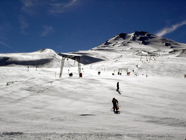
THE CHILLAN SPAS
It is located at 82 km. east of Chillán. It is a modern winter complex, a national and international competition center and also integrates a spa center. It is also a place in the Andes abundant with vegetation and fauna. It is place of excursions. Its varied and extended ski trails helped create sport competitions during the months of July and September.
The tourist complex has 10 cable lifts and 3 cable seats ( one of 2500 m. the longest in South America). The ski school provides classes of snowboard and Nordic ski realized by national and foreign instructors. It has hotels and condominiums.
The season extends from the months of May to October
ANTUCO
It is located at 604 km. south of Santiago and at 89 km. east of Los Angeles. It altitude is 1400 m. above sea level.
Its trails are situated in the skirts of the Antuco volcano which is in the north part and is surrounded by the waters of the Laja lagoon. Prat of it is inserted in the National Park of Laja Lagoon. It has 3 cable ferries, restaurants, cafeteria, bar, equipment rentals and ski classes. The season is form June to October.
VIII Region: National Parks
THE “LAGUNA DEL LAJA” NATIONAL PARK
It is located at 210 km. south-east of Concepción. It is an area of 11.600 hectares with an altitude of 976 to 2979 m. above sea level. In this area, it is possible to find some sorts of species of flora and fauna in the middle of a pre-Andes landscape full of waterfalls, a volcano, rivers, lagoons, sierra and natural viewpoint places.
Among the species of flora are some woods of mountain cypress, araucarias, maiten del Chubut and Radal erano in addition to La maihuencia and cactus which are considered exclusive of the Andes zone of the region.
The birds constitute the main population of fauna with 47 species among pajarillos anátidos, rapaces and the condor. We can also find the very important Cordillera partridge and the Andes seagull.
Among the most important attractions are the las Chicas and Torbellino waterfalls, both constitute the formation of the Laja river. The rivers of the zone are apt for salmon fishing and the Biobio river is apt for sport activities and adventure due to its many rapids. Also, there is the interesting Velluda and Los Coigües Sierra which are located in the El Chacay sector.
“RALCO” NATURAL RESERVATION
it is located at 114 km. east of Santa Bárbara and at 71 km. from the Ralco village, bordering the Pangue river. It was created to protect the Araucaria Pines of the Ralco Estate. It has superficies of 10.000 hectares with a diversity of native plants and fauna. In the interior of there reservation there are paths of 30 km. which helps to know, among other points of interest, the Mula lagoon, the Quillaicahue valley and the Ralco river.
VIII Region: Beaches and Creeks
CONCEPCIÓN
The regional capital and is located at 86 km. east of Bulnes. A University and cultural center that has a maritime climate and intense industrial, commercial and financial activities.
In the Plaza de Armas of Concepción and on the 10th of January of 1818, the Independence of Chile was claimed. Afterwards, the plaza was renamed as the Plaza de la Indepenecia.
The city was founded by Don Pedro de Valdivia in 1550. Now, it is a modern city with important cultural centers and an active University life. It is united with the rest of the country by plane, train and highway.
At the surroundings, there are many points of interest such as: the Biobío river outlet, the University quarter, the Municipal Market, the Mural of the central Station, the Cathedral, the Ecuador Park, the Art House ( Pinacoteca), the Museum of Concepción, the big and small lakes of San Pedro, San Pedro Chapel, Llacilén Municipal resort, the Biobío river, the Escuadrón Beaches, the Amarillo and Caracol hills, the Juan Pablo II Bridge, the Tribunals Palace, the Plaza de la Independecia, the History Gallery, the rests of the stone walls of the Merced Convent and the Mausoleum of general Don José María de la Cruz.
TALCAHUANO
It is the main military, industrial and fishing port of the south zone of the country. It is located at 16 km. north-east of Concepción.
It has a population of 220.000. it is an important national industrial center that has iron and steel industry, petrochemical complex, a shipyard, metal and mechanical industry and sea products elaboration companies.
The most relevant attractions of Talcahuano and its surroundings are: the Huáscar monitor, Ramuntcho and Rocoto beaches, the Biobío river outlet, the San Pedro Fiesta, the fish Market, the Hualpén Museum and Park, the Ventana seaside road, the iron and steel factory, Huachipato, the Los Perales hill, the Quiriquina hill, the Martínez de Rosas Street, the La Gloria hill, the Nuevo hill, the O’Higgins General Quarters and the Hualpén peninsula natural Sanctuary.
COBQUECURA
An extended beach located at 105 km. north-west of Chillán and where you would find some curious rocky formations such as “La Lobería” which serves as a refuge for Sea wolves.
Cobquecura is a coastal village of extended beaches. At few blocks, you would find the “Piedra de la Lobería” where thousands of Sea wolves live. At the south of the village, you could visit: the Mure, Piedra Alta and Rinconada beaches. You could also go to the Cueva de Huilquincura which is a profound mysterious cave. At the north, there are: The Piedra Church which is built on an enormous rock at the sea. You can get inside through two natural forados and watch the enormous vault similar to that of a church.
Cobquecura offers more than 50 km. of beaches all of which are apt for fishing meager, small meager, Roberto, sole, etc..
TOME
It is a city that is identified by its textile industries and by its broad streets and modern constructions.
It is located at 29 km. north of Concepción. It has a big touristic relevance because rural and coastal surroundings.
Its beaches start further to the south of Punta de Parra. The latter, which can be reached by train, has been pre-selected buy many to spend their vacations and swim.
At the entrance of the city is the Bellavista beach where there is a factory with the same name.
In the same quarter, near to the industry, there is a chapel of German style architecture built by Germans living in the area and who also reflected this architecture on the surrounding houses.
The most important attractions of Tomé are the Sea Museum, El Morro, Dichato, Puda Burca, Coliumo, Pingueral, Bellavista and Punta de Parra beaches. There is also the Coiumo, Merquiche, Purema Bays and at 31 km. to the north the Las Vegas de Itata.
CHIVILINGO
A coastal locality located at 10 km. south of Lota. It has narrow beaches that extend to 1500 meters. It has white sands and surrounded by green hills which protects them form the wind.
It is distinguished for possessing the Chivilingo Hydroelectric station, a historical cultural and tourist heritage which was constructed in 1897 which made it the first hydroelectric station in the country and the second in South America. It was declared a National Monument in 1990.
It also has dark sandy and long beaches, which are perfect for fishing and sunbathing.
LARAQUETE
A coastal locality situated at 13 km. south of Lota. Its main activity is oriented towards the artisan fishing which provides the numerous restaurants with their gastronomical specialties.
The Laraquete beach is distinguished for its mild waves which permits the practice of many aquatic sports along with the Cruces river with its unique stones that are carved by the artisans of the area.
ARAUCO
A coastal city located at 71 km. south of Concepción. It is population 30.000 who are dedicated to the forestall industry and the artisan fishing activities. It is the main center for Cellulose production.
The Arauco, Llico, Tubul, Punta lavapié beaches are located there. Its historic symbol is the Colo Colo hill, which is an ancient site of the Arauco Fortress. It is one of the oldest cities of Chile which was founded in September 1553. Its coast, together with the gulf and the cordilleras of Nahelbuta offers various natural attractions of beaches and cordilleras.
LEBU
A coastal city located at 145 km. south of Concepción and is the capital of the Arauco province.
Its coast offers many attractive beaches and cliffs. Don Cornelio Saavedra founded it in 1862. It is located in the low parts of the cordilleras of the coast at the banks of the Lebu River and the sea.
Its population is 25.000. Its main economical activities are artisan fishing, forestall and mining.
The main attractions of Lebu and its surroundings are: the Caupolicán Plaza, Plaza de Armas, La Cruz hill, Lebu river and cave, Millaneco and Lebu beaches, river port, Bucalebu and Boca del rio Lebu.
TIRÚA
A coastal village located at 50 km. south of the Lanalhue lake. It is rich in sea gastronomy, has a rural setting the offers attractive beaches, a river and a lagoon.
Its population is 9000. The major part is rural (81%). The important economical activities are the artisan fishing, forestall exploitation and agriculture. Their attraction are beaches, rivers and lagoons amongst which is Tirúa beach, located at 121 km. of Concepción and has and extension of 5 km. and is apt for fishing, picnic and Photography.
LOTA
It is an old mining village located at 9 km. south of Coronel. It is a village the depends on the exploitation of Carbon which was started in 1852 by don Matías Cousiño.
It was founded in 1662 by t he Spanish Governor Abgel de Peredo and on the 5th of january 1875, Lota was declared as a city. In 1852, Don Matías Cousiño purchases the lands where later he would establish the carbon industry.
Lota is divided in two sectors: Low and High. Low Lota is located between the hills of the valley near to the sea where the public service offices and the commerce are located. In high Lota, there are the installations of the mine and the typical houses of a mining camp.
The most distinguished attractions are the Isidora Goyenechea de Cousiño park, now known as Lota Park which was designed by Doña Isidora, the Chivilingo, Negra and Colcura beaches, the carbon Mine, the San Matás Church, the Prat viewpoint, and the Villagra seaside road.
A virgin carved from carbon and artisan articles made of carbon are the main attractions of the artisan articles. It also has the Lota and Colcura Fortresses and the hydroelectric plant of Chivilingo, also declared a Historical Monument.
From Lota, it is possible to travel by boat to the Santa María island.
CORONEL
A fishing city located at 31 km. south of Concepción beside the Pacific. Later it developed around the carbon exploitations of Schwager. At the moment, its economy is developing around the fishing, forestall and industrial activities.
It was founded on the 30th of august 1849 by Don Jorge Rojas Miranda, founder of the Carbon industry. Coronel has developed around the carbon industries which gave it its golden years and permitted the elaboration of an adequate infrastructure. Thew attractions are the big Industrial Park and port, the Blanca, Lagunilla and Punta Puchoco beaches.
LIRQUÉN
A small fishing area located at 15 km. north of Concepción. The typical characteristic of the port of Lirquén is the “Barrio Chino ” where the houses of the fishermen has converted with time as restaurants where you can taste the typical sear product plates that are composed of a variety of seafood and especially mussels, pink clams, clams, piures, crabs which are offered either raw or steam cooked. These products are also sold on the way.
THE COCHOLGUE BEACH AND FISHING PORT
It is situated at 6 km. north of Tomé. This narrow and sheltered beach is sectioned by rocks that exist as a result of the erosion of the two steeps that abruptly fell into the sea from an height of 50 meters which caused the separation of the north and the south small fishing ports..
The beach has transparent waters with fine and white sands but is not apt for swimming.
The contemplation in a the rough seas and the tasting of sea products are the main attractions of this part of the Pacific.
DICHATO
It is a beach of the north sector of Concepción at only 10 km. north of Tomé which is an ideal site for the practice of aquatic sports and swimming.
VIII Region: Rivers and waterfalls
THE ITATA WATERFALLS
The waterfall is located at 18 km. west of Yungay and it has cascades of 75 m. high. Looking towards the end of Los Acantilados, you can see an abundance of vegetation with shrubs and wild flowers. It has a picnic area during the summer season.
It is considered one of the highest in South America because of its altitude and according to some technicians, its water force is equivalent to 100.000 watts.
Following the same course of the Itata river, you would reach El Saltillo Itata which you can watch form the viewing point that overlooks a naturally-formed lake.
In addition to having many trees such as willow and elm tress, there is also a picnic and camping area. It is a good place for fishing, especially in the falls, with abundance of trout, salmon and pejerry. It is apt for swimming, excursions and photography.
THE LAJA WATERFALLS
It is a waterfall that is located at 479 km. form the Panamericana South highway. The water of the Laja river falls from a height of 35 m. in a rocky canon which is an impressive show that can be appreciated form the highway.
The main fall has an altitude of 55 m. and can be seen for the highway. The second fall is 35 m. high and the third, which is in the middle of the others, is 20 m. The landscape is constituted by rockrose vegetation. The tourist facilities are varied and of good level.
ANTUCO
It is located at the cordillera of the Andes at 85 km. east of Los Angeles. Its main attraction is the Laja lake national Park and the water cascades of the Velo de la Novia and Salto del Trubunleo which have their eaters falling form a considerable height that causes mild mist in the area.
THE QUENCO RIVER
Its outlet is at 50 km. from Rlaco, in the Biobío river. It springs out form the skirts of the Copahue volcano its white waters border an unpaved road for 115 km.
VIII Region: Spas
TERMAS DE CHILLAN (THE SPAS OF CHILLAN)
It is located at 82 km. east of Chillán. It is a modern winter complex and spa center which is located at a view point in the cordilleras covered with abundant vegetation and fauna. It is an excursion place.
Spa Center: It is located at 1800 m. above sea level. Its thermal waters has a temperature that goes between 27 and 65 º C. The waters are half mineralized and god for the treatment of: arthritis, skin diseases and respiratory illnesses.
It extended and varied ski trails paved the way for sport competitions to be held during the months of July to September.
In this pre-Andes place you can appreciate the caves, waterfalls and small lakes and abundant vegetation and fauna amongst which we are: the Condor and the woodpecker along with the Pudú dear, huemules, foxes, etc..
Moreover, it is possible to practice activities such as: promenades and ascending to the Chillán volcano, skiing, excursions, bathing in spas, visiting “La cueva de los Pincheira”, fishing in the Diguillín river, etc..
It has hotels and condominiums.
THE AVELLANO SPAS
These spas are located at 75 km. south of Santa Barbara at the banks of the Biobío river on the road to Ralco Lepoy. It get inundated in the spring by the waters of the Biobío river which transforms it into a “thermal water swimming pool” in the middle of beautiful landscape. It has plane land and places for camping.
Adventure tourism
THE CAJÓN DEL ÑUBLE VALLEY
This place is located at 5 km. north-east of Chillán, bordering the Ñuble river ( 43 km. paved and 22 km. unpaved road).
Th landscape presents an abrupt mountainous heights covered by colonies of native vegetation that grow on rocks among fountains and Saltos de agua. The river Ñuble springs from the lower part.
THE SPAS OF CHILLAN
It is located at 82 km. east of Chillán. It is a modern winter complex, a national and international competition center and also integrates a spa center. It is also a place in the Andes abundant with vegetation and fauna. It is place of excursions. Its varied and extended ski trails helped create sport competitions during the months of July and September.
The tourist complex has 10 cable lifts and 3 cable seats ( one of 2500 m. the longest in South America). The ski school provides classes of snowboard and Nordic ski realized by national and foreign instructors. It has hotels and condominiums.
In this pre-Andes place you can appreciate the caves, waterfalls and small lakes and abundant vegetation and fauna .
Moreover, it is possible to practice activities such as: promenades and ascending to the Chillán volcano, skiing, excursions, bathing in spas, visiting “La cueva de los Pincheira”, fishing in the Diguillín river, etc..
It has hotels and condominiums.
THE QUEUCO VALLEY
It is located at 78 km. south-east of Los Angeles. It starts in the locality of Ralco and extends to the Trapa Trapa valley. The access is difficult during the winter because of the climatic conditions. This valley is located at the feet of the Copahue Volcano and it has a longitude of 50 km. It is placed among the big heights of the Cordilleras and its beginning is formed by the ravine of the Queuco river. There are various fountains, salto de agua and leafy native trees. The thermal fountains of the Nitrao and Chancocó are located in this valley.
THE JORGE ALESSANDRI RODRÍGUEZ PARK
It is a forestall extension center of 11 hectares that is located at 18 km. south of Concepción. It was created to make known to the public about the forestall activities of Chile. It has a broad collection of plant species, some of which are in extinction and its fauna has species like, Pudú dear, lamas and a great variety of birds that live permanently and seasonally there. There are many guided tours that shows you the advances of the Technology of the silviculture of pine trees and the native woods of more than 200 years.
VIII Region: Yumbel
It is a locality situated at 71 km. south-east of Concepción. Its origin goes back to the antique Fortress of San Felipe de Austria, constructed in 1585. In 1766, it was given the title Villa and named as a patron for San Sebastián whose celebration date, the 20th of each January, attracts tourists and people of the place to visit the San Sebastián Sanctuary.
The main economical activity is agriculture which employs the 57% of its active work force. In the last few years, the forestall activities has incremented and play an important role in the economy of the area.
Among its attractions, we can sight the Sanctuary which has the image of San Sebastián, the Claro river resort, located at 3 km. from Yumbel and the Salto de Laja resort, located at 24 km. form the exit of the Panamerciana highway, direction to Los Angels.