Lonely Planet, the prestigious travel guide, recently selected Aysen Region as one of the top 10 Regions to travel on 2017. Here are the 3 trekking trails you cannot miss.
“There’s only one road into the Aysén region of Chilean Patagonia and if you follow its unpaved contours from start to finish you’ll experience a kaleidoscopic journey where foggy fjords give way to brooding rainforests, bone-dry pampas and powder- blue lagoons. Shaped by the forces of the Patagonian Ice Field – Earth’s third-largest freshwater reserve – Aysén is an extreme landscape in constant flux. But with fresh routes to glaciers, a booming craft-beer scene in remote hamlets and a massive new nature reserve green-lit for national-park status, Patagonia’s last frontier has never been such a delight to explore.”
These were the words used by Lonely Planet professionals to describe the amazing wonders of Aysen Region in southern Chile. If you are a fan of trekking, and you are thinking of travelling to Chilean Patagonia, not only will you need to bring warm clothes to fight the southern cold, you will also need to know what trails to take in order to fully enjoy this beautiful land.
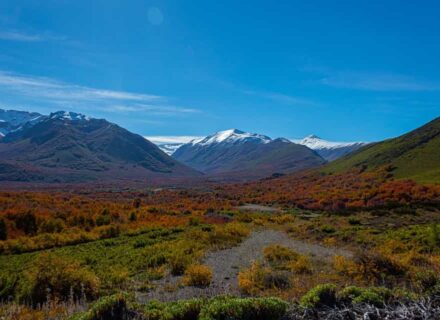
Aysén Region is mainly composed of sinuous valleys and steep mountains, besides having staggering landscapes all around. This makes the region a perfect place for practicing trekking, going over by foot and discover all the area’s nature. Because of this, there are many national reserves and parks that have established trails specially for this sport, which implies walking for days or hours through different trails, slopes, valleys, and crossing rivers or woods. 42
Lago Verde
Lago Palena: This trail is located 225 km from Chaitén (140 miles). It starts in the area of Lago Verde, close to the border with Argentina, and ends in Lago Palena National Reserve. It is a trail of a bit more than 55 km (34 miles) long and it takes 4 days to be completed. It can be done by foot or by on horse. During the trip, you will see many fields in planting process, few lagoons and you will have to cross the Quinto river in more than one opportunity, also, the snowed Andes mountains can be seen in all their majesty. Then, you can enter the almost virgin Lenga woods. Due to the complexity of the territory where the trail is set, it is considered a high level difficulty trail.
Cerro Castillo:
This is one of the best circuits of the country, which goes through unbelievable landscapes surrounding the hill, and where it is possible to see Huemules (a unique type of deer). There are also Lenga woods, and lots of water, snow, and rocks. It is 50.4 km long (31 miles) and it takes 4 days to be completed. This trail starts in the Astral Highway, 70 km (44.5 miles) from Coyhaique, exactly in Las Horquetas Grandes sector. The entrance value is $2000 for local adults (USD $3.5), $1000 (USD $1.5) for local children, and $3000 (USD $4.5) for international adults. It is also considered a high level difficulty trail.
Río Ventisquero:
This patrimonial trail is located in the middle of the Austral Highway, 59 km (36.6 miles) to the southeast of Chaitén. It is a total of 6 km (4 miles) roundtrip, has 2 stretches, and it takes 2 hours each to be completed. However, it is recommended to extend this time in order to enjoy the landscape and take some pictures. It starts in the El Fogón sector, where the SNUPIE n°1 (a type of sign)is located, and ends in the lookout on SNUPIE n°25 from which the Ventisquero river can be fully contemplated. This trail has a great biodiversity and species like the Coigue and Canelo trees. Birds such as the Chucao or the Churrín can also be spotted along this trail. In addition, the hanging glaciers can be seen during the whole trail. This is a low level difficulty trail.