| A valuable, unique and fragile heritage is combined with an ancient and peculiar culture, strongly isolated and with a history of exploitation and abandonment. This complexity currently explains the precarious situation of the natural and archeological heritage of Easter Island, and the controversial relation between the ones involved.
By Rosario Mena. |
|
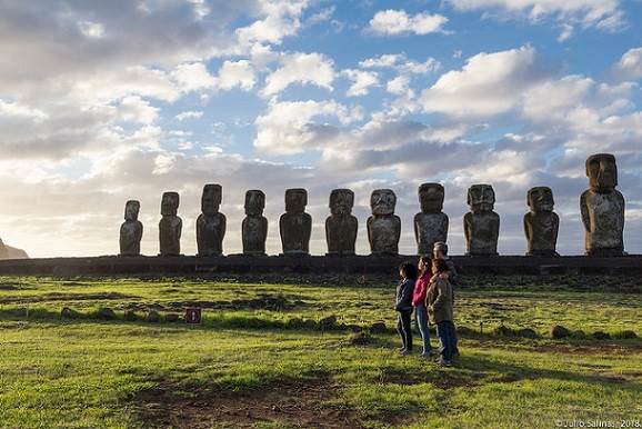
Ancestral Statues The moais are the symbol of Rapa Nui. During the splendor of the megalithic time of the rapanui culture —between the X and XVII centuries— more than eight hundred images were carved in stone, in order to incarnate the lineage founder’s spirit and proyect his “maná” over their descendents and land, through their view. After being placed over an “ahu” (altar), their socket would open to receive coral eyes and obsidian. Then, they would transform to the vivid face (“aringa ora”) of an ancestor.
Of the 838 moais registered to this date, 397 are located on the Rano Raraku quarry, all of them with complete stages of carving. 288 are placed over an “ahu”, and the rest were abandoned during their transfer. The majority were carved on the tufa of Rano Raraku, but some are found on red escoria, traquita and basalt. The tools for the carving were pillory and basalt adzes, called toki. Most of the raw materials were manageable, though basalt offered an exceptional challenge. The average size of the moais carved on Rano Raraku was of 14.7 feet, but a gigantic one —of over 68.8 feet— was left unfinished. It would have weighed two hundred tons, something impossible to move. The two biggest moais that reached their destination over an “ahu” are 32.3 feet tall. An exceptional moai carved on basalt was placed in one of the houses of “the Birdman village”, in Orongo. The shapes carved on its back, typical of the time following the decadence of the megalithism, make it a unique historical document. It was moved by british sailors on 1868 and taken to the London Museum, where is now being exhibited in the middle of its cafeteria. When moved from the island, the natives named it “hoa haka nana ia” (“the stolen friend”). Transportation is still one of the island mysteries. While different methods have been experimentally “proved” —sliding the statues layed over sleighs made of trunks and pulled by ropes, or making them tilt on vertical position— recent excavations on the “moai roads”, show a much more complex system, which uses vertical posts placed over the two sides of a specially prepared road, and that suggests the lengthy use of ropes and levers. It is clear that transportation was the hardest task in the whole process. Over the centuries, moais show a clear evolution in style and size. The most ancient models are smaller and of a naturalistic style, much closer to the prototypes of the core of ancestral Polynesic cultures (Tahiti, Marquesas), from where the whole system that found in Rapa Nui the stimulus for a new growth was developed. With time, moais became increasingly stylized and larger, until reaching impossible shapes. The explanation for this process, that ended up collapsing the Megalithism, should be found in the ancient aristocratic order’s intention of maintaining the system when the production pressures outgrew the loading capacity of its fragile ecosystem, until reaching the environment collapse. The moais were left abandoned, like mute witnesses of an unsustainable order. All the ones placed over an “ahu” were knocked down, and the eyes that once projected an ancestor’s maná were destroyed. Most of the structures were converted into ossuaries to deposit the whitened bones of family members. Mankind’s Heritage: Rapa Nui National Park Most of the 270 altars (“ahu”) and almost 900 statues or moais —that characterize the classical time or “ahu-moai phase”, between the X and XIV centuries— are located in the Rapa Nui National Park, named by the UNESCO as a World Heritage site in 1995. A highlight is Orongo´s ceremonial village, center of the Tangatu Manu (Birdman) ritual, which characterizes the adaptation phase that follows the end of Megalithism (“huri-moai phase”, between the years 1600 and 1800). Named as Easter Island Tourism National Park, it was created in 1966 with over 17,200 acres wide. Two years later, the scarce importance of the Park as a protected area was made clear, when a Ministry of Agriculture’s act gave the Park only the lands of Rano Kau and Maunga Terevaka (11,740 acres), leaving on the side of the ranch the most important archeological areas (over 19,400 acres). In 1972, the Forestal National Corporation (CONAF) was created. It is a semi-private organization that depends on the Ministry of Agriculture, with the forestation as its main goal. It was also assigned with the tuition, management and control of the State Protected Natural Areas National System (SNASPE), where the Rapa Nui National Park is included. But not until 1976 a more consistent delimitation was reached, between the Park´s principles and goals, just as it is described on their first Management Plan (CONAF, 1976). It is then than it receives its current name: Rapa Nui National Park. That same year, the smaller islands (motu) adjacent to the island´s Southwest corner are declared Nature´s Sanctuary. Even though CONAF’s management plans describe goals and development, zoning, programs, activities and regulations; its implementation is far from being effective or guarantee the valuing and conservation of the cultural heritage inside the Park. In 1983, the Park´s land grew to 16,460 acres. In 1999, the demand for agricultural land for the islanders was met with the surrender of 2.470 acres as agricultural land, taken from the ranch and the Park —which lost zones such as the inside of Vaihu and Akahanga— while incorporating a part of the Poike peninsula (the Northern coast, which includes the sites of Vai A Heva and Ana O Keke, the oriental halve of the peninsula that contains “ahu” with small traquita moais and a wide eroded zone, and the board of the cliff from the South); the Maunga Ana Marama and the socket of Rano Aroi (the crater and depression that goes down to Vaitea, with the lava tunnels of the Vai Pu area, where endemic vegetation grows, mostly ferns). This way, the surface of the Park grew to 17,600 acres. But these new areas have not been effectively incorporated to the protection, because of the lack of human resources and materials. The Issue of Conservation of Rapa Nui Archeological Heritage Big carved blocks (“paenga”) from an “ahu” also served for the construction of water tanks, as it can be seen in Hanga Tetenga. One of the first public works of some relevance was the construction of the Mataveri airport, on the mid-60s. It meant the store and transfer of thousands of tons of surface material, including countless archeological sites and materials. Its enlargement, in 1988, needed the excavation of Maunga Tararaina. Wide zones were devastated to build the landing lanes, which were then filled with stones and structure of archeological value. The lack of studies of environment impact and of control over the construction of some roads are other threats to the heritage conservation. The conservation of the island´s archeological materials should be directed to the mitigation of the effects of the exposition to the outdoors, where rain and wind are the critical elements, but mainly to the control of the animals that freely circulate, the public use of sites and education. The combination of these elements differentially affects the materials, and one can see how the moais show different degrees of damage. The experimental use of waterproof products has shown its effectiveness, but its systematic use has not yet been reached. From the hundreds of moais now exposed to the growing damage for natural reasons, there are a dozen that require urgent care. The deepest damage is provoked by animals and vandalism. Till now, the closing of some sites has proved expensive and useless. It would seem more efficient and sustainable in all senses, to install animals in proper and fenced areas. One of the worst damages that animals do is not only the stepping, but the burning of pastures that comes from the old use of getting fresh grass. The handling of the animals that use Rano Raraku´s water is the most difficult problem. Even if the island´s vandalism is not a massive problem, the use of some guides to highlight the petroglifos to improve their “visibility” is increasingly damaging one of the most notable expressions from the island’s archeology. A lot of the monumental sites require a regular preventive maintenance, on a different scale. Among the most-at-risk sites there is the area of Mata Ngarau, on the ceremonial village of Orongo. The village itself has been restored many times but, the same as with all important sites, it requires a permanent preventive maintenance. Its blocks with petroglifos are on a highly risked physical condition. Twice, this site has been placed on the ranking of the “100 Most-At-Risk Sites” in the world. About monumental restoration, it has to be very controlled, specially about the scientific registration. Currently, it is necessary to evaluate the interventions made in a number of sites and update management plans. The Rapa Nui National Park, as the first Chilean site on the World Heritage Ranking and what that implies in terms of responsibility for the nation, needs more human resources and materials to fulfill its mission. From that perspective, it is necessary to insist in a new management model that can improve its budget by the way of tourism and with the support and participation of authorities and local organizations, in order to direct it to the protection and conservation of the Rapanui heritage. |
Rapa Nui: Tale of an Abandoned Island
/